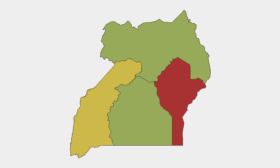
Situation Summary
Uganda's composite threat score of 68 (rank #21 globally) reflects persistent fragmentation across military, political, and civil domains. A confirmed border clash on 21 July between UPDF and South Sudanese forces at Kajo-Keji signals renewed regional instability, while concurrent military operations and media-related incidents suggest domestic tension. The Eastern Region (77.3) remains the highest-risk sub-national area, driven by cross-border activity and armed group presence. Overall trajectory remains volatile but localized; no nationwide emergency is imminent, but Eastern and Western zones require sustained attention.
Key Developments
- Kajo-Keji border area (Uganda–South Sudan), 21 July 2026: UPDF and SSPDF clashes reported in Nandejo village following a border dispute; civilian displacement confirmed. This marks the most recent geo-specific security incident.
- National-level military operations, 19–21 July: Multiple reports of conventional military force deployments across Uganda; specific locations and operational scope not yet clarified in available reporting.
- Government–media relations, 20–21 July: Physical assault on media personnel reported 20 July; government statements issued 21 July regarding press-related disputes, including statement attributed to Uganda vs. Associated Press. Suggests elevated tension around information control.
- Investigative activity, 21 July: Two separate investigative actions reported at national level; subjects and scope unclear from available signals, but indicate active law-enforcement or security apparatus engagement.
- Prime Minister public statement, 21 July: High-level government communication issued; content not yet detailed, but timing alongside military and media incidents suggests coordinated messaging or response.
Note: Web verification confirms only the Kajo-Keji border clash and media incidents with strong timestamp confidence. Other signals from the platform event feed lack detailed sourcing within the 24–48-hour window; background on arbitrary arrests and media siege (July 16) falls outside the current brief window.
Highest-Risk Areas
The Eastern Region (77.3) dominates Uganda's risk profile, primarily due to the South Sudan border dynamics, cross-border militia activity, and limited state capacity. The Western Region (64.8) follows, reflecting ongoing armed-group presence and resource competition. Northern Region (58.6) and Central Region (54.8) register lower but still material risk, with Northern driven by LRA-residual activity and Central by proximity to Kampala's political volatility. Corporate personnel and assets in Eastern and Western zones face compounded exposure from both armed actors and state military operations; border-proximate work requires heightened protocols.
How GeoBit Would Assist
Intel Sweep and OSINT Fusion would consolidate real-time military movements, political signaling, and media incidents into a unified operational picture, eliminating the current gaps in scope and scale. AOI Monitoring & Early Warning focused on Kajo-Keji, Kisangani corridors, and Kampala political nodes would provide persistent alerting on troop concentrations, protest risk, and access disruption before they affect duty-of-care obligations. Conflict & Military (battle mapping, force structure) and GIS & Spatial Analysis would enable route re-planning around active military zones and real-time corridor safety assessment for field teams.
7-Day Outlook
Border friction is likely to persist or intensify if diplomatic channels remain closed; the UPDF–SSPDF clash suggests no imminent de-escalation. Domestic political and media tension may manifest in increased checkpoints, travel delays, or arrest waves targeting perceived critics—typical pre-election or consolidation-phase behavior. Teams should expect operational friction (curfews, restricted movement) in high-risk zones and maintain flexible staffing and communication contingencies.
Highest-Risk Areas — Ranked
| # | State / Region | Risk |
|---|---|---|
| 1 | Eastern Region | 77.3 |
| 2 | Western Region | 64.8 |
| 3 | Northern Region | 58.6 |
| 4 | Central Region | 54.8 |
Sources
Previous Daily Briefs
A new Uganda brief is written every day — each with its own risk map and downloadable CSV. Here's the last week; use the calendar to go further back.
📅 Browse every day by calendar →
Highlighted days have a brief. Tap a day for that day's map & analysis, or “csv” for that day's dataset ($5).
Atlas — our AI intelligence desk — emails them this snapshot personally. Nothing else, no list.