Situation Summary
Ukraine remains the 6th highest-threat country globally, driven by active large-scale conflict and 645 tracked security events. Over the past 48 hours, Russian forces have conducted sustained multi-city aerial campaigns targeting civilian infrastructure across Kyiv, Kharkiv, Dnipro, and Mykolaiv, resulting in at least 30 confirmed civilian deaths and over 200 injured since 5 June. Simultaneously, Ukrainian forces are executing offensive operations in the southeast, having retaken approximately 600 km² this year with the heaviest engagement occurring this week near Oleksandrivka and Huliaipole.
Key Developments
- Kyiv, 9 June 2026: Large-scale air attack involving cruise missiles, ballistic missiles, and drones struck the capital, causing civilian injuries and significant damage to education and medical facilities; attack corroborated by UN Security Council briefing and international media.
- Kharkiv city, 9–10 June 2026: Russian forces conducted sustained overnight missile and glide-bomb strikes on residential districts, killing several civilians and injuring dozens, with extensive damage to apartment blocks and energy infrastructure reported by regional authorities.
- Dnipro city, 9 June 2026: Russian missile strikes on residential and commercial zones killed and injured civilians; attack was referenced in UN emergency Security Council briefing on nationwide casualties.
- Mykolaiv city, 9–10 June 2026: Shahed-type drone and missile attacks struck industrial and port-adjacent areas overnight, causing fires, power outages, and minor injuries.
- Southeast Ukraine frontline (Oleksandrivka/Huliaipole sectors), early June 2026: Ukrainian commander Syrskyi reported heaviest fighting this week in these southeast sectors as part of broader offensive operations; Ukraine has retaken ~600 km² since start of 2026.
- Diplomatic tensions, 10–11 June 2026: Multiple rejection and disapproval statements recorded between Ukraine-Russia and Hungary-Ukraine, alongside UN-directed public statements by Ukrainian officials, indicating elevated political friction concurrent with military operations.
Highest-Risk Areas
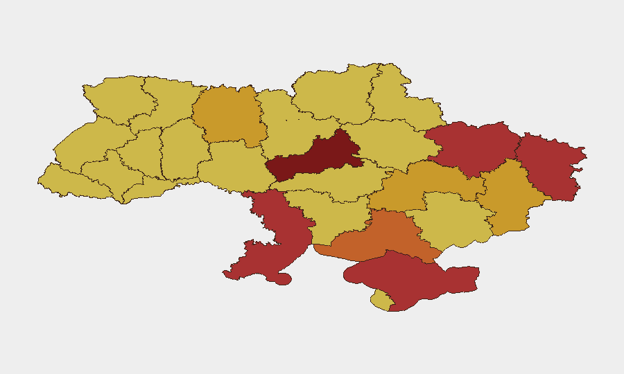
Kyiv (risk 100) and Cherkasy Oblast (94.4) dominate the threat ranking, reflecting the capital's status as a primary Russian targeting objective and Cherkasy's proximity to active operations and logistical networks. Contested or occupied territories—Crimea (79), Kharkiv (76.5), Luhansk (76.5), Donetsk (72.5), and Kherson (75.1) oblasts—remain elevated due to ongoing military operations, infrastructure strikes, and civilian displacement. Southern and central regions including Odesa (77.2) and Dnipropetrovsk (72.9) face sustained drone and missile threat from Russian strikes on ports, energy systems, and population centers. Risk in all regions is primarily driven by active kinetic conflict and the demonstrated willingness of Russian forces to conduct large-scale civilian-area strikes.
How GeoBit Would Assist
Security teams should leverage AOI Monitoring & Early Warning to establish persistent watch on key corporate or personnel locations in Kyiv, Kharkiv, and Dnipro, with alert triggers tied to air-raid activity and confirmed strike zones. Conflict & Military mapping combined with GIS & Spatial Analysis enables real-time routing and network analysis to identify safer transit corridors and alternative supply chains around active frontlines and strike zones. Intel Sweep and OSINT fusion (including radio SIGINT, event feeds, and Telegram/X monitoring) provide 24-hour corroboration and early warning of escalating attack patterns, diplomatic shifts, or localized threats before they impact operations.
7-Day Outlook
Russian aerial campaigns are likely to persist at current intensity, targeting major urban centers and energy infrastructure to degrade Ukrainian civilian morale and logistics. Ukrainian offensive operations in the southeast are expected to continue, sustaining elevated ground-level threat in Donetsk, Luhansk, and adjacent oblasts. Corporate and humanitarian operations in all major cities should anticipate recurring air-defense alerts and infrastructure disruption.
Highest-Risk Areas — Ranked
| # | State / Region | Risk |
|---|---|---|
| 1 | Kyiv | 100 |
| 2 | Cherkasy Oblast | 94.4 |
| 3 | Autonomous Republic of Crimea | 79 |
| 4 | Odesa Oblast | 77.2 |
| 5 | Kharkiv Oblast | 76.5 |
| 6 | Luhansk Oblast | 76.5 |
| 7 | Kherson Oblast | 75.1 |
| 8 | Dnipropetrovsk Oblast | 72.9 |
| 9 | Donetsk Oblast | 72.5 |
| 10 | Zhytomyr Oblast | 71.6 |
| 11 | Rivne Oblast | 70.9 |
| 12 | Sevastopol | 70.8 |
Sources
Previous Daily Briefs
A new Ukraine brief is written every day — each with its own risk map and downloadable CSV. Here's the last week; use the calendar to go further back.
📅 Browse every day by calendar →
Highlighted days have a brief. Tap a day for that day's map & analysis, or “csv” for that day's dataset ($5).