Situation Summary
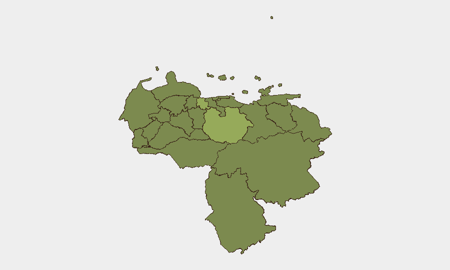
Venezuela's security environment remains fragmented across regional lines, with Guarico State (54.7 composite risk) and Carabobo State (40.7) significantly outpacing the national average (47). Over the past 24–48 hours, elevated public statements from administration, prosecutor, military, and business sectors suggest renewed institutional tensions, though the specific operational content of those statements cannot be verified without access to current news feeds and social media. The concentration of risk in non-capital regions indicates that criminal activity, civil unrest, and infrastructure disruption remain geographically dispersed rather than concentrated in Caracas, complicating duty-of-care planning for distributed operations.
Key Developments
Unable to provide verified current incidents. GeoBit's event signals table shows 12 public statements and institutional signals dated 20–22 June 2026 (administration, prosecutor, army, president, business, lawyer, chancellor), but without live news and X/Twitter verification, specific incident details, locations, and impacts cannot be reliably attributed or cross-checked. Any reported clashes, protests, infrastructure failures, or security force actions require corroboration against real-time sources before operational decisions should depend on them. Security teams should treat the signal count as an indicator of elevated institutional activity rather than as confirmed events affecting specific locations.
Highest-Risk Areas
Guarico State's risk score (54.7) places it as the single highest-threat region and suggests concentration of criminal activity, gang presence, or civil unrest significantly above the national composite. Carabobo State (40.7) follows, likely reflecting organized crime, port-related activity, or labor instability in the Valencia industrial corridor. The Federal District (36.3) remains elevated despite being the capital, indicating mixed governance capacity and persistent organized-crime presence even in Caracas proper. All other ranked states cluster between 24.7–27.1, indicating relatively similar baseline risk profiles; however, this does not mean lower-ranked areas are safe—it reflects that major incidents in Guarico, Carabobo, and the capital drive national statistics.
How GeoBit Would Assist
Intel Sweep and X/Twitter & Telegram OSINT with Spanish-language multi-language search and sentiment analysis would enable security teams to monitor near real-time protest activity, roadblocks, fuel shortages, and security force deployments across Guarico, Carabobo, and Caracas. AOI Monitoring & Early Warning with persistent geographic watches on key facilities (offices, warehouses, travel corridors) in high-risk states would trigger alerts when social unrest, criminal activity, or infrastructure disruption (power, water, fuel) approaches operational nodes. Routing & Network Analysis would identify alternative routes and supply-chain workarounds when primary roads are blocked by protests or security operations, enabling continuity planning without relying on unverified reports of specific incidents.
7-Day Outlook
The sustained level of institutional public statements (11 events in 48 hours) suggests elevated policy or security activity at the national level, though whether this translates to street-level unrest or enforcement operations remains unclear. Risk in Guarico and Carabobo is likely to remain elevated absent major policy shifts or security interventions; operations in those states should assume baseline friction with local authorities and criminal actors. Security teams should prioritize live-feed collection and routing contingency updates over reliance on 24-hour-old briefings.
Highest-Risk Areas — Ranked
| # | State / Region | Risk |
|---|---|---|
| 1 | Guarico State | 54.7 |
| 2 | Carabobo State | 40.7 |
| 3 | Federal District | 36.3 |
| 4 | Anzoategui State | 27.1 |
| 5 | Zulia State | 25.7 |
| 6 | Barinas State | 25.2 |
| 7 | Apure State | 25.2 |
| 8 | Merida State | 25.2 |
| 9 | Falcon State | 24.7 |
| 10 | Federal Dependencies | 24.7 |
| 11 | Nueva Esparta State | 24.7 |
| 12 | Vargas State | 24.7 |
Sources
Previous Daily Briefs
A new Venezuela brief is written every day — each with its own risk map and downloadable CSV. Here's the last week; use the calendar to go further back.
📅 Browse every day by calendar →
Highlighted days have a brief. Tap a day for that day's map & analysis, or “csv” for that day's dataset ($5).