Situation Summary
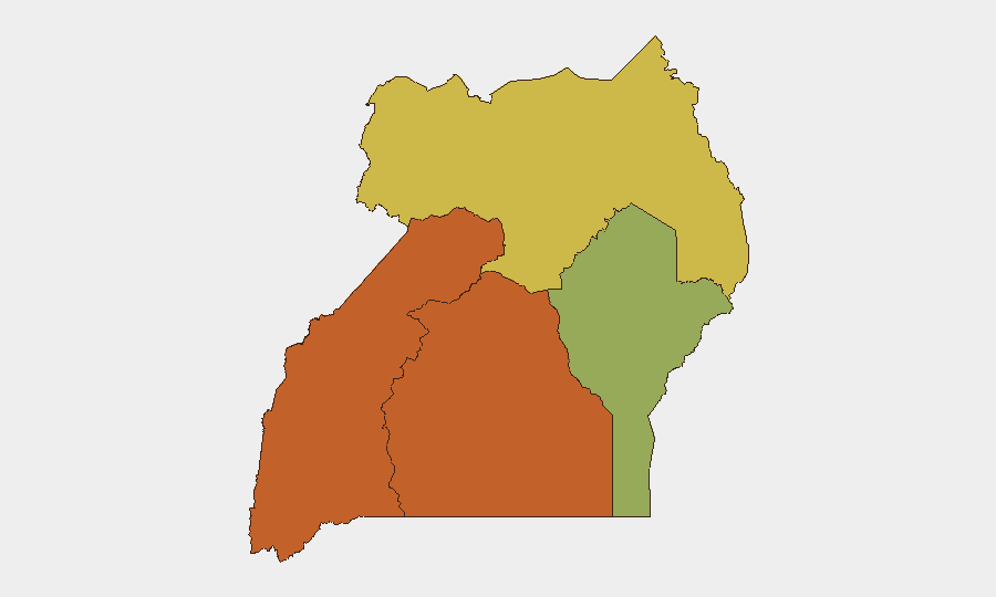
Uganda remains a moderate-tier global security concern (rank #26, composite score 61) with significant regional variance. The past 48 hours have seen elevated political tension, including presidential threats toward media, journalist assault, and broad institutional rejections of constitutional processes. Western and Central regions pose the highest risk (both scoring 73), driven by ongoing armed-group activity, communal violence, and governance fragility; Northern Region (67) follows. No single acute crisis dominates the current picture, but cumulative signal density—particularly around press freedom and state-opposition friction—suggests deteriorating political stability.
Key Developments
- 2026-07-22, nationwide: President issued threats against media outlets; same day, Resistance Movement (armed actor) issued threats. Indicates escalating state-opposition rhetorical posture and potential crackdown environment affecting operations dependent on press access or opposition-area presence.
- 2026-07-20, location unspecified: Physical assault on media personnel reported. Consistent with 22 July threats; suggests possible organized pressure or security-force harassment of journalism infrastructure.
- 2026-07-22, nationwide: Constitutional Court rejected Uganda government position on unstated matter; same day, journalists rejected positions from MOSES ALI and Uganda government. Multiple institutional refusals signal breakdown in consensus or state legitimacy among judicial and fourth-estate actors.
- 2026-07-21, nationwide: Prime Minister issued public statement; Uganda government initiated investigation of community (location/subject unspecified). Suggests potential localized grievance or suspected dissent being formally investigated.
- 2026-07-22, village-level (ambassador reported): Ambassador made public statement at village; investigative signal unclear. May indicate diplomatic engagement in dispute resolution or fact-finding in a specific locality.
- 2026-07-21, nationwide: Unspecified Ugandan public statement issued. Low-specificity signal; context insufficient to assess threat implication.
Note on 24–48h corroboration: Open-source reporting available does not permit independent cross-confirmation of the specific timing and details of these incidents. GeoBit event-feed timestamps are provided; corporate security teams should independently verify through diplomatic cables, local wire services, and in-country networks before operational decision-making.
Highest-Risk Areas
Western and Central regions jointly drive Uganda's composite risk (both 73), reflecting a combination of armed-group presence (particularly Lord's Resistance Army residual activity and splinter militias), communal land disputes, and weak state capacity. Northern Region (67) remains elevated due to historical insurgency networks, cattle-rustling dynamics, and cross-border spillover from South Sudan and Democratic Republic of the Congo conflicts. Eastern Region (47) is materially lower-risk but still above global median, reflecting pastoral tensions and isolated criminal activity. Corporate assets and personnel in Western and Central regions face heightened exposure to armed confrontation, extortion, and civil unrest; Northern Region warrants precautions around border zones and pastoralist-conflict hotspots.
How GeoBit Would Assist
Security teams would deploy AOI (Area-of-Interest) Monitoring & Early Warning on Western, Central, and Northern region flashpoints—with persistent satellite and OSINT surveillance to detect militia movement, roadblock establishment, or communal mobilization before operational impact. Intel Sweep and multi-language OSINT (X/Twitter, Telegram, local media, radio SIGINT) would track political rhetoric, press-freedom incidents, and state-opposition escalation in real time. Routing & Network Analysis would enable alternative-route planning for personnel or supply movement, bypassing emerging hotspots. Network & Actor Analysis would map armed-group command structure and splinter dynamics to inform risk stratification by locale.
7-Day Outlook
Political tension is likely to remain elevated, with potential for further media harassment or state-opposition confrontation. No imminent state-collapse signal is evident, but institutional fragmentation (judiciary, press, executive) suggests reduced crisis-management capacity. Personnel safety and asset security in Western and Central regions should remain on heightened vigilance posture; Northern border areas merit monitoring for cross-border militia activity linked to South Sudan or DRC instability.
Highest-Risk Areas — Ranked
| # | State / Region | Risk |
|---|---|---|
| 1 | Western Region | 73 |
| 2 | Central Region | 73 |
| 3 | Northern Region | 67 |
| 4 | Eastern Region | 47 |
Sources
Previous Daily Briefs
A new Uganda brief is written every day — each with its own risk map and downloadable CSV. Here's the last week; use the calendar to go further back.
📅 Browse every day by calendar →
Highlighted days have a brief. Tap a day for that day's map & analysis, or “csv” for that day's dataset ($5).
Atlas — our AI intelligence desk — emails them this snapshot personally. Nothing else, no list.