Situation Summary
Angola remains a stable-to-moderate risk environment (global rank #52, composite score 35) with no major acute security incidents reported in the last 24–48 hours. Economic pressures—particularly subdued oil-driven growth and structural fiscal challenges highlighted in the IMF Article IV consultation—continue to underpin socio-economic stress, though no active civil unrest, terrorism, or organized crime spikes are confirmed in current open-source reporting. Wildfire activity across central and southern provinces has been detected but poses secondary operational risk; political and governance stability remain the primary structural concern.
Key Developments
- 2026-06-27, Luanda/national: One arrest/detention incident involving a company and Chinese nationals reported; limited detail available in open sources. Further corroboration and operational context pending.
- 2026-06-26, national: Angola issued two public statements on Africa-level diplomatic or institutional matters; no security or conflict implications reported.
- 2026-06 (ongoing), central/southern Angola: Multiple wildfires detected in Quando Cubango, Lunda Norte/Sul, Bié, and adjacent DRC border regions. No direct threat to major urban centers or critical infrastructure confirmed; humanitarian and environmental monitoring recommended for field teams in affected provinces.
- 2026-06-25–26, Luanda: IMF Article IV consultation finalized, underscoring structural fiscal and growth challenges (oil production decline, elevated inflation); no specific new security incident, but economic stress may increase protest risk or informal-sector volatility over medium term.
- No armed conflict, terrorism activity, kidnapping, or major crime events confirmed in mainstream or institutional reporting for the past 48 hours.
Highest-Risk Areas
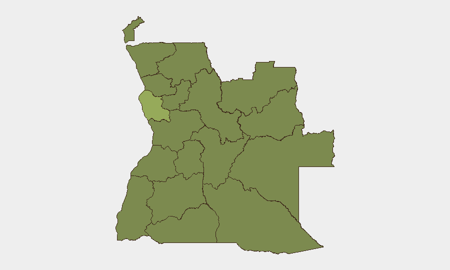
Luanda Province dominates the sub-national risk profile (54.7), driven by concentration of critical infrastructure, expatriate populations, and socio-economic density; security incidents and petty/organized crime in the capital carry highest operational impact. Cuando Cubango Province (34.7) ranks second, likely reflecting border instability and resource competition. The northern provinces—Lunda Norte/Sul, Cabinda, Zaire, Uíge—cluster at moderate-to-moderate risk (24.7) owing to diamond mining disputes, cross-border trafficking, and governance gaps; Luanda's risk score is substantially higher and warrants priority monitoring. Interior provinces (Bié, Cuanza Norte/Sul, Malanje, Bengo) at the 24.7 baseline reflect lower incident density but should remain under routine surveillance.
How GeoBit Would Assist
Intel Sweep and global event feeds provide real-time corroboration of arrest/detention and diplomatic incidents, supplemented by X/Twitter & Telegram OSINT and multi-language search to track evolving narratives around the Chinese nationals incident and economic/social sentiment. AOI Monitoring & Early Warning with persistent watch on Luanda, Cuando Cubango, and northern mining provinces would flag emerging protests, roadblocks, or crime surges before they impact operations. Satellite & Imagery analysis can track wildfire perimeter and smoke dispersion to inform travel routing; Routing & Network Analysis identifies alternative road/air corridors if primary arteries are threatened by fire or flooding.
7-Day Outlook
No imminent spike in armed conflict or mass unrest is forecast. Economic headwinds and inflation will likely sustain low-level social friction and informal-sector volatility, particularly in Luanda. Wildfire activity may persist through the dry season; teams in central/southern provinces should maintain situational awareness and pre-positioned evacuation plans. Diplomatic and arrest developments warrant continued monitoring for broader implications on expatriate safety or business continuity.
Highest-Risk Areas — Ranked
| # | State / Region | Risk |
|---|---|---|
| 1 | Luanda Province | 54.7 |
| 2 | Cuando Cubango Province | 34.7 |
| 3 | Lunda Norte Province | 24.7 |
| 4 | Lunda Sul Province | 24.7 |
| 5 | Cabinda Province | 24.7 |
| 6 | Zaire Province | 24.7 |
| 7 | Bengo Province | 24.7 |
| 8 | Uíge Province | 24.7 |
| 9 | Cuanza Norte Province | 24.7 |
| 10 | Cuanza Sul Province | 24.7 |
| 11 | Malanje Province | 24.7 |
| 12 | Bié Province | 24.7 |
Sources
Previous Daily Briefs
A new Angola brief is written every day — each with its own risk map and downloadable CSV. Here's the last week; use the calendar to go further back.
📅 Browse every day by calendar →
Highlighted days have a brief. Tap a day for that day's map & analysis, or “csv” for that day's dataset ($5).