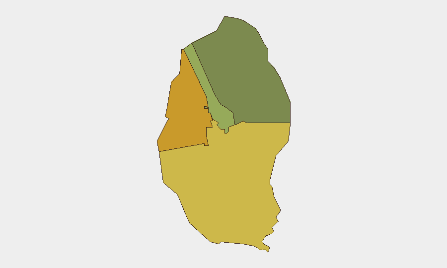
Situation Summary
Bahrain faces an acute military threat following Iranian missile and drone strikes on 10–11 July 2026, targeting US military installations and prompting immediate air-defence responses across the Kingdom. Multiple Iranian attacks on Gulf partners (Kuwait, Qatar, UAE) within the same 48-hour window signal a coordinated, widened campaign that has triggered US Embassy security alerts and a shift to elevated national posture. The Northern and Southern Governorates carry the highest composite risk (72 and 68 respectively), reflecting proximity to military concentrations and cross-border vulnerabilities; civilian exposure remains limited to date, but the trajectory is toward sustained tension and unpredictable secondary incidents.
Key Developments
- Naval Support Activity Bahrain, Manama – 11 July 2026
Iranian state media and IRGC announced missile and drone strikes on the US Fifth Fleet headquarters. Video evidence shows air-defence engagement (interceptor fire, smoke) over Manama's night sky; US and Bahraini officials have not confirmed significant structural damage to the base, indicating effective interception.
- Bahrain airspace, Kingdom-wide – 11 July 2026 morning
Bahraini air-defence systems intercepted and destroyed Iranian aerial threats (drones and missiles) before impact on populated areas or critical infrastructure, according to official statements and corroborating social-media reports.
- US military perimeters, Bahrain – last 48 hours through 11 July
Intelligence assessments report low-flying, radar-evading drone and missile swarms probing US base defence perimeters in Bahrain, consistent with Iranian operational patterns observed simultaneously in Kuwait and the UAE.
- Regional escalation across the Gulf – 10–11 July 2026
Iran conducted coordinated attacks on Bahrain, Kuwait, Qatar, and the UAE, described by regional and government sources as retaliation for earlier US strikes and maritime incidents in the Strait of Hormuz; characterized as violations of an existing ceasefire framework.
- US Embassy security alert, Bahrain – 11–12 July 2026
The US Embassy advised American citizens to avoid large gatherings, areas with heightened security presence, and to shelter in place due to unpredictable military activity and ongoing regional escalation; no confirmed civilian casualties reported to date.
Highest-Risk Areas
The Northern Governorate (composite risk 72) and Southern Governorate (risk 68) drive Bahrain's threat profile, reflecting their concentration of military infrastructure, cross-border proximity to Iranian territory and contested waters, and historical flashpoint status in Iran–GCC disputes. Capital Governorate (risk 45), including Manama, faces secondary but significant risk due to US Fifth Fleet presence and its role as administrative and commercial hub; Muharraq Governorate (risk 38) carries lower but material exposure to air-defence activity and potential secondary effects. Risk is concentrated at military and strategic sites rather than distributed across civilian areas at present.
How GeoBit Would Assist
Security teams would deploy AOI Monitoring & Early Warning against Northern and Southern Governorate military sites and Manama harbour to detect force movements, air-defence activations, and maritime activity; Maritime & Aviation tracking to monitor commercial and military traffic disruptions; and OSINT fusion (X/Telegram OSINT, YouTube/podcast intelligence, multi-language search) to correlate official statements, IRGC claims, and local reports in real time. Conflict & Military battle mapping and force-structure analysis would establish baseline US and Bahraini deployments and track repositioning.
7-Day Outlook
Iranian and allied messaging suggests further strikes may follow if US or regional responses escalate; Bahrain's air defences have performed effectively, but sustained tension and secondary incidents (accidental fire, miscalculation, non-state actor activity) remain credible. Commercial and aviation disruptions are likely to persist, with no near-term de-escalation signalled by either Iranian or US-led Gulf coalition statements.
Highest-Risk Areas — Ranked
| # | State / Region | Risk |
|---|---|---|
| 1 | Northern Governorate | 72 |
| 2 | Southern Governorate | 68 |
| 3 | Capital Governorate | 45 |
| 4 | Muharraq Governorate | 38 |
Sources
Previous Daily Briefs
A new Bahrain brief is written every day — each with its own risk map and downloadable CSV. Here's the last week; use the calendar to go further back.
📅 Browse every day by calendar →
Highlighted days have a brief. Tap a day for that day's map & analysis, or “csv” for that day's dataset ($5).
Atlas — our AI intelligence desk — emails them this snapshot personally. Nothing else, no list.