Situation Summary
Barbados remains a low-threat jurisdiction with a stable security environment and no validated acute incidents in the last 24–48 hours. The composite threat score of 3 places the nation at the lower end of global risk, and current open-source monitoring confirms no security incidents, civil unrest, major crime spikes, or infrastructure disruptions within the reporting window. Police and defence-force activity is limited to routine operations and planned security measures for upcoming festival events.
Key Developments
- No validated acute incidents in Barbados in the last 24–48 hours; web, social-media, and event-feed monitoring confirm stable conditions across all parishes.
- Flash flood and severe thunderstorm watches lifted nationwide; isolated thunderstorms possible but no infrastructure damage or transport disruption reported in the current 24–48 hour window.
- Planned Crop Over security operations (forward-looking, not incident-driven): Barbados Police Service and Barbados Defence Force have announced enhanced joint patrols, drone/CCTV surveillance, checkpoints, and traffic diversions for upcoming climax events (Foreday Mornin' Jam, Grand Kadooment), scheduled as standard measures, not crisis response.
- Police leadership and organizational restructuring ongoing as part of modernization; no indication of new unrest, extraordinary deployments, or incident-driven redeployment in the last 48 hours.
Highest-Risk Areas
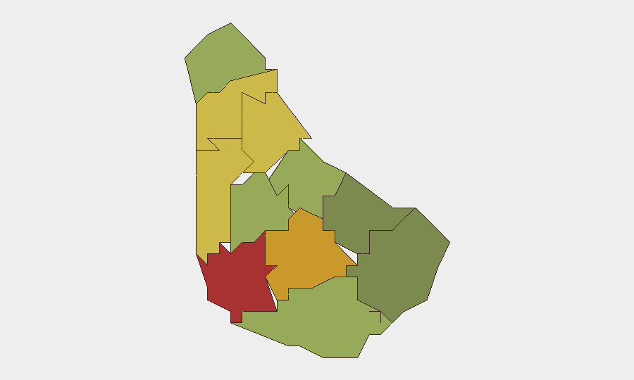
Saint Michael (risk 78) and Saint George (risk 72) lead the sub-national ranking and account for the majority of baseline risk, driven by urban concentration, population density, and historical crime prevalence in the capital and surrounding parishes. Saint James (68) and Saint Andrew (65) follow. These four parishes form a geographic cluster encompassing Bridgetown and its suburbs; risk is endemic to urbanization and social-economic factors rather than acute events in the reporting window. Southern parishes (Saint Philip, Saint John, Christ Church) show substantially lower composite scores (28–42), reflecting lower population density and historically lower incident frequency. Risk concentration in the north-central urban corridor is a persistent structural pattern, not a recent escalation.
How GeoBit Would Assist
Intel Sweep, OSINT Fusion & Corroboration, and X/Twitter & Telegram OSINT enable real-time monitoring of emerging security, crime, and civil-unrest signals across Barbados, with temporal and sentiment analysis to filter noise and confirm incident validity. AOI Monitoring & Early Warning with persistent watch over Saint Michael, Saint George, and other high-risk parishes provides advance alerting if conditions deteriorate or planned events (Crop Over) trigger disruption. Routing & Network Analysis can support duty-of-care teams in charting alternative transit routes and identifying safe zones during festival periods when checkpoints and traffic diversions take effect.
7-Day Outlook
The security environment is expected to remain stable over the next seven days, with the main operational consideration being the planned intensification of police and defence-force presence during Crop Over festivities. These measures are designed to manage crowd safety and traffic flow rather than respond to emerging threats. No significant escalation of baseline risk is anticipated unless severe weather or unexpected incident triggers a rapid change in posture.
Report Date: 30 July 2026 | Next Update: 31 July 2026
Highest-Risk Areas — Ranked
| # | State / Region | Risk |
|---|---|---|
| 1 | Saint Michael | 78 |
| 2 | Saint George | 72 |
| 3 | Saint James | 68 |
| 4 | Saint Andrew | 65 |
| 5 | Saint Peter | 62 |
| 6 | Saint Joseph | 58 |
| 7 | Saint Thomas | 52 |
| 8 | Saint Lucy | 48 |
| 9 | Christ Church | 42 |
| 10 | Saint John | 35 |
| 11 | Saint Philip | 28 |
Sources
Previous Daily Briefs
A new Barbados brief is written every day — each with its own risk map and downloadable CSV. Here's the last week; use the calendar to go further back.
📅 Browse every day by calendar →
Highlighted days have a brief. Tap a day for that day's map & analysis, or “csv” for that day's dataset ($5).
Atlas — our AI intelligence desk — emails them this snapshot personally. Nothing else, no list.