Situation Summary
Belarus remains stable internally with no verified major security incidents in the last 24–48 hours, according to open-source monitoring and official statements. The primary risk vectors are hybrid-pressure tactics at EU borders (particularly Latvia) and persistent latent military concerns along Ukraine and NATO peripheries, rather than acute threats or civil unrest within the country. Belarusian defense officials publicly characterize the military-political situation as "stable" with minimal NATO/Ukrainian activity, though neighboring states view Belarus as part of a coordinated destabilization campaign. Overall threat trajectory remains low-intensity and controlled, with localized border frictions rather than escalation.
Key Developments
- Minsk, 2026-07-22 – Belarusian Defense Minister Viktor Khrenin briefed President Lukashenko and publicly stated the military situation around Belarus is "stable," reporting no signs of NATO or Ukrainian preparations for aggression and only minimal neighboring military exercises. This official assessment reflects current official confidence in border security.
- Belarus–Latvia border, ~2026-07-24–25 – Latvia's Prime Minister characterized recent migrant-crossing attempts as part of a coordinated Belarus–Russia "hybrid campaign" to destabilize the EU eastern border. While not an acute incident, this signals persistence of cross-border pressure tactics and EU-side political escalation of rhetoric.
- Belarus–Poland border, late July 2026 – Open reporting notes a significant *decrease* in illegal crossing attempts into Poland, attributed to reinforced Polish border controls and migration policy measures. This indicates reduced short-term border incident pressure on the southern frontier.
- Belarus–Ukraine border, 2026-07-22–25 – Belarusian officials reiterated no observed Ukrainian military preparations for aggressive action along the shared border. Ukrainian sources continue to characterize the latent military threat from Belarus as "still real," but no new border incidents or force movements are timestamped in the last 48 hours.
- Domestic Belarus, mid-to-late July 2026 – No verified large-scale protests, riots, terror attacks, or infrastructure disruptions are reported in open-source monitoring over the last 24–48 hours. Routine internal-security activity and political repression continue without new acute events.
Highest-Risk Areas
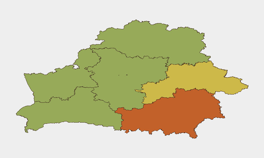
Homyel Region (risk 75) and Minsk city (risk 68) drive the composite threat ranking, with Homyel's proximity to Ukrainian territory and potential cross-border military activity, and Minsk's role as the political and administrative center making it a focal point for internal security operations and potential hybrid-action targeting. Mahilyow, Brest, and Hrodna regions (62, 55, and 52 respectively) reflect ongoing border-security concerns along Ukraine, Poland, and Latvia sectors. Risk scores reflect latent military/hybrid threats and border frictions rather than current acute incidents; no region shows signs of imminent civil unrest or major crime escalation in the last 24–48 hours.
How GeoBit Would Assist
Corporate security teams should deploy AOI Monitoring & Early Warning on Homyel, Minsk, and border zones (Latvia, Poland, Ukraine) to detect changes in military activity, force movements, or migrant-pressure surges in near-real time. OSINT Fusion & Corroboration across Telegram, X, and local Belarusian news streams, combined with sentiment & temporal analysis, provides early indication of civil-unrest catalysts or official policy shifts before they escalate. Conflict & Military force-structure and weapons-capability tracking, paired with border & disputed-territory search, enables teams to distinguish latent from acute military risk and validate official stability claims against ground truth.
7-Day Outlook
No major escalation or acute incidents are anticipated in the next 7 days based on current official assessments and border-activity trends. Hybrid-pressure tactics at the EU frontier will likely persist at current low-to-moderate intensity, and internal repression will remain routine. Monitoring for unexpected military-exercise announcements, sudden border-crossing spikes, or changes in official rhetoric remains prudent for duty-of-care planning.
Highest-Risk Areas — Ranked
| # | State / Region | Risk |
|---|---|---|
| 1 | Homyel Region | 75 |
| 2 | Minsk | 68 |
| 3 | Mahilyow Region | 62 |
| 4 | Brest Region | 55 |
| 5 | Hrodna Region | 52 |
| 6 | Minsk Region | 48 |
| 7 | Vitsebsk Region | 45 |
Sources
Previous Daily Briefs
A new Belarus brief is written every day — each with its own risk map and downloadable CSV. Here's the last week; use the calendar to go further back.
📅 Browse every day by calendar →
Highlighted days have a brief. Tap a day for that day's map & analysis, or “csv” for that day's dataset ($5).
Atlas — our AI intelligence desk — emails them this snapshot personally. Nothing else, no list.