Situation Summary
Belize remains under a State of Emergency with persistent gang and inter-cartel violence concentrated in Belize City and surrounding districts. Shooting incidents, armed robberies, and homicides are the primary threat vectors, with law enforcement conducting intensified enforcement operations in affected communities. Countrywide telecommunications disruptions on 24 July underscored vulnerability in emergency-response coordination. The overall national threat trajectory remains elevated but localized, with 95% of tracked risk concentrated in Belize District.
Key Developments
- Unitedville, Cayo District (2026-07-26): Police investigated a triple shooting near the village bus stop that resulted in one fatality and two injuries. The incident reflects escalation of armed violence beyond the capital into secondary urban centers.
- Belize City, Cemetery Road (2026-07-26): A 19-year-old construction worker was shot and injured by two men on a motorcycle. Injuries were reported as non-life-threatening; incident consistent with gang-related targeting patterns.
- Belize City, multiple neighborhoods (2026-07-24): Three separate shooting incidents occurred within 24 hours, including at least one double homicide, attributed to ongoing gang and inter-cartel activity. Incidents demonstrate sustained operational capability of violent actors despite enforcement presence.
- Belize City, Handyside Street (2026-07-24): Armed robbery at a pawn shop resulted in the owner's son being shot and wounded. Armed robbery-homicide nexus indicates financial targeting and willingness to use lethal force.
- Countrywide telecommunications outages (2026-07-24): Intermittent internet and mobile disruptions were reported across multiple districts, degrading emergency-services coordination and real-time situational awareness during periods of active violence.
- Enforcement intensification (2026-07-24): Security forces escalated operations in gang-affected communities as part of State of Emergency response, indicating sustained government commitment but also suggesting limited tactical progress to date.
Highest-Risk Areas
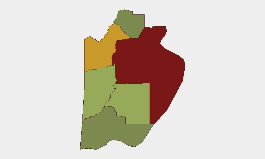
Belize District dominates the threat landscape with a composite risk score of 95, reflecting Belize City's concentration of gang infrastructure, turf disputes, and armed-crime networks. Orange Walk District (risk 72) and Cayo District (risk 58) show secondary but significant risk, with the Unitedville shooting demonstrating that violence is no longer confined to the capital. Stann Creek, Toledo, and Corozal districts remain substantially lower-risk but should not be assumed secure; secondary urban nodes (Dangriga, San Ignacio, Orange Walk Town) warrant monitoring for spillover activity, particularly along drug-trafficking corridors.
How GeoBit Would Assist
Security teams should deploy AOI Monitoring & Early Warning on Belize City neighborhoods and secondary urban centers (Dangriga, San Ignacio, Orange Walk Town) to track shooting incidents, enforcement operations, and gang activity in near-real-time. Network & Actor Analysis combined with OSINT fusion (X/Twitter, Telegram, local news feeds, police radio SIGINT) would enable identification of emerging cartel or gang activity, leadership changes, and territorial shifts. Routing & Network Analysis supports duty-of-care teams in real-time journey planning around active violence zones and telecommunications blackout areas.
7-Day Outlook
Armed violence is likely to persist at current intensity through early August, with gang-driven homicides and armed robberies remaining the primary threat. Telecommunications resilience will be critical; further outages could impede emergency response and corporate incident reporting. Law enforcement escalation suggests authorities perceive operational momentum; however, without disruption of gang leadership or supply networks, tactical operations alone are unlikely to reduce threat levels significantly in the near term.
Highest-Risk Areas — Ranked
| # | State / Region | Risk |
|---|---|---|
| 1 | Belize District | 95 |
| 2 | Orange Walk District | 72 |
| 3 | Cayo District | 58 |
| 4 | Stann Creek District | 48 |
| 5 | Toledo District | 35 |
| 6 | Corozal District | 22 |
Sources
Previous Daily Briefs
A new Belize brief is written every day — each with its own risk map and downloadable CSV. Here's the last week; use the calendar to go further back.
📅 Browse every day by calendar →
Highlighted days have a brief. Tap a day for that day's map & analysis, or “csv” for that day's dataset ($5).
Atlas — our AI intelligence desk — emails them this snapshot personally. Nothing else, no list.