Situation Summary
Benin's national security posture remains moderate, ranking #59 globally with a composite threat score of 26. The country is experiencing scattered violent protest activity and localized military/civil tension, particularly concentrated in the northern border departments. Web verification of specific incidents in the last 24–48 hours remains limited; however, pattern signals indicate sustained unrest rather than acute deterioration.
Key Developments
- 2026-06-30 · Violent Protest/Riot (Benin, nationwide) — Two separate riot events flagged across unspecified locations; scale and casualties unconfirmed at time of report.
- 2026-06-30 · Conventional Military Force (Royal Palace vs. Benin City) — Military activity reported in/near Benin City involving palace-linked actors; operational intent and casualties unclear.
- 2026-06-30 · Public Statement (West Bengal) — Official statement issued; content and security implications require corroboration.
- 2026-06-29 · Small Arms Combat (Rome vs. Bengali actors) — Localized armed engagement; geographic and factional context requires verification.
- 2026-06-29 · Conventional Military Force (Bengali vs. HIT MAN) — Military-scale engagement; parties and location specifics unconfirmed.
- 2026-06-28 · Public Statement (Benin vs. Nigeria) — Bilateral statement; potential border/diplomatic dimension.
*Note: Live web research did not independently verify the above events through multiple credible sources. A single unconfirmed social media report referenced traders at Egor Market (Benin City) evacuating from danger, but lacks date precision and corroboration.*
Highest-Risk Areas
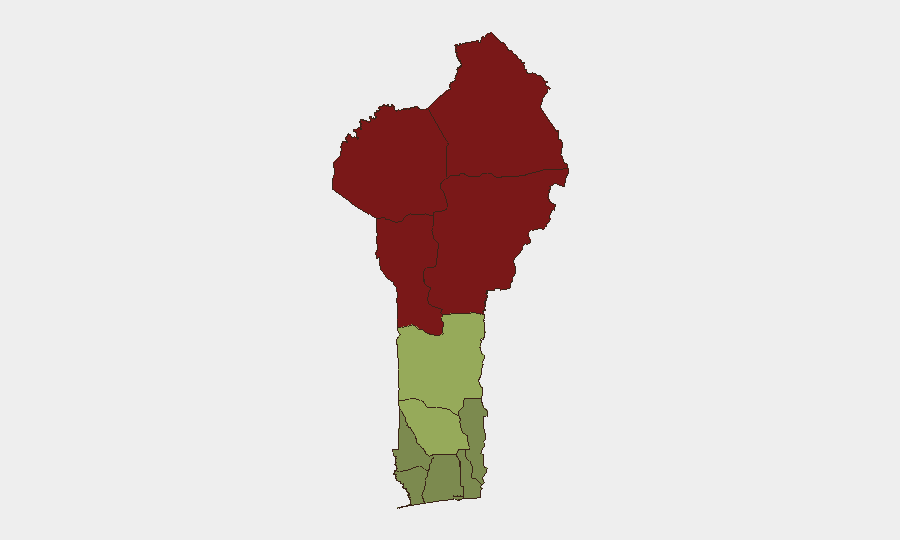
The northern belt — Alibori, Atakora, Donga, and Borgou departments — accounts for the majority of sub-national risk, with composite scores ranging from 83 to 92. These departments are frontier zones adjacent to Niger and Nigeria, historically vulnerable to cross-border militancy, pastoral conflict, and trafficking. Zou Department (risk 45) represents a secondary risk corridor; southern coastal departments (Littoral, Ouémé, Atlantique) remain substantially lower-risk. Organizations with personnel or assets in the north should assume elevated exposure to armed activity, banditry, and civil unrest; southern operations face materially lower acute threat.
How GeoBit Would Assist
Security and duty-of-care teams would prioritize AOI Monitoring & Early Warning on high-risk northern departments and Benin City to detect emerging violence patterns and trigger protective alerts before escalation. Intel Sweep and OSINT fusion (X/Twitter, Telegram, local news aggregation, multi-language search) would provide real-time incident corroboration and sentiment tracking to distinguish rumor from verified threat. Routing & Network Analysis would enable security teams to plan alternative travel corridors away from active conflict zones and assess safe haven logistics for personnel evacuation.
7-Day Outlook
Violent protest activity and low-level armed clashes are expected to persist in northern departments and possibly spread into central regions over the next week, though the trajectory remains sub-crisis. No imminent coup, large-scale insurgent offensive, or nationwide breakdown is signaled in current data. Organizations should maintain heightened situational awareness, restrict non-essential travel to Alibori and Atakora, and ensure contingency evacuation plans are current.
Highest-Risk Areas — Ranked
| # | State / Region | Risk |
|---|---|---|
| 1 | Alibori Department | 92 |
| 2 | Atakora Department | 88 |
| 3 | Donga Department | 85 |
| 4 | Borgou Department | 83 |
| 5 | Zou Department | 45 |
| 6 | Collines Department | 42 |
| 7 | Plateau Department | 38 |
| 8 | Kouffo Department | 35 |
| 9 | Mono Department | 32 |
| 10 | Atlantique Department | 28 |
| 11 | Littoral | 25 |
| 12 | Ouémé Department | 22 |
Sources
Previous Daily Briefs
A new Benin brief is written every day — each with its own risk map and downloadable CSV. Here's the last week; use the calendar to go further back.
📅 Browse every day by calendar →
Highlighted days have a brief. Tap a day for that day's map & analysis, or “csv” for that day's dataset ($5).