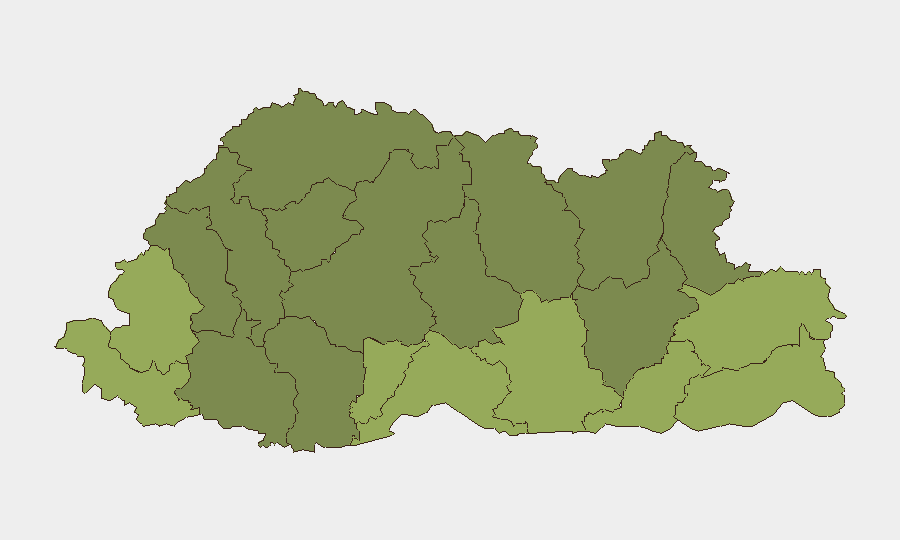
Situation Summary
Bhutan remains one of the world's lowest-risk countries, with no credible security incidents, civil unrest, or infrastructure disruptions reported in the last 24–48 hours. The national composite threat score of 3 reflects the country's consistent political stability, low crime rates, and strong rule of law. Current indicators suggest no acute triggers that would warrant elevated travel or operational security postures for organizations with people or assets in the country.
Key Developments
No significant security, conflict, or civil unrest events meeting incident thresholds were reported in Bhutan during the 24–48 hour window ending 4 July 2026. Open-source reporting and social media feeds from the past day show no verified Bhutan-specific incidents, travel disruptions, or policy changes of operational relevance. Regional security reporting during this period has concentrated on Myanmar/Rakhine and Bangladesh border dynamics rather than Bhutanese territory. The absence of reportable events is consistent with Bhutan's typical low-conflict baseline, though limited international media coverage in the country should be noted as a factor in event detection. A public statement from Bhutanese authorities was logged on 3 July 2026; full content and scope require direct source review to assess operational relevance.
Highest-Risk Areas
Samtse, Sarpang, and Haa districts (risk scores 58, 55, and 52 respectively) drive the highest sub-national composite risk, likely reflecting proximity to India–Bhutan border regions and historical cross-border movement patterns. Pemagatshel and Samdrup Jongkhar districts (scores 50 and 48) follow, again suggesting southern and southeastern border proximity as a primary risk factor. By contrast, central and western districts (Lhuntse, Wangdue Phodrang, Gasa) register substantially lower scores, indicating lower exposure to border-related incidents and criminal activity. Organizations with operations or personnel in the southern border districts should apply heightened awareness protocols around cross-border movement, informal trade networks, and entry/exit points, though absolute risk levels remain low.
How GeoBit Would Assist
Intel Sweep and OSINT fusion would provide continuous monitoring of Bhutanese news, social media, and official channels to detect emerging civil, political, or security shifts in real time. AOI Monitoring & Early Warning applied to Samtse, Sarpang, and other high-risk districts would enable persistent geofencing and alert triggers for border activity, protests, or infrastructure damage, reducing reliance on delayed public reporting. GIS & Spatial Analysis and Routing & Network Analysis would support journey planning and alternative-route identification for personnel transiting southern border districts, minimizing exposure to highest-risk corridors during elevated-alert periods.
7-Day Outlook
No acute drivers are expected to materially alter Bhutan's security baseline over the coming week. Seasonal monsoon weather patterns may affect road conditions in southern districts but pose no security threat. Continued monitoring of the 3 July authorities' statement and routine border-region activity is prudent; absent new incident reporting, the operational posture toward Bhutan should remain routine and baseline-protective.
Highest-Risk Areas — Ranked
| # | State / Region | Risk |
|---|---|---|
| 1 | Samtse District | 58 |
| 2 | Sarpang District | 55 |
| 3 | Haa District | 52 |
| 4 | Pemagatshel District | 50 |
| 5 | Samdrup Jongkhar District | 48 |
| 6 | Tsirang District | 45 |
| 7 | Zhemgang District | 42 |
| 8 | Trashigang District | 40 |
| 9 | Mongar District | 38 |
| 10 | Gasa District | 35 |
| 11 | Lhuntse District | 32 |
| 12 | Wangdue Phodrang District | 30 |
Previous Daily Briefs
A new Bhutan brief is written every day — each with its own risk map and downloadable CSV. Here's the last week; use the calendar to go further back.
📅 Browse every day by calendar →
Highlighted days have a brief. Tap a day for that day's map & analysis, or “csv” for that day's dataset ($5).
Atlas — our AI intelligence desk — emails them this snapshot personally. Nothing else, no list.