Situation Summary
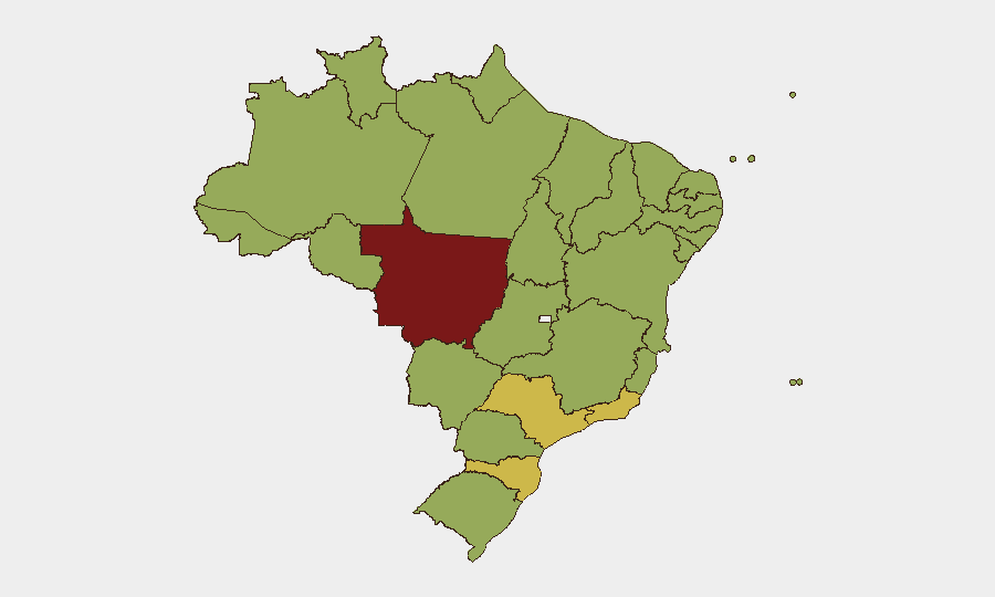
Brazil remains a composite risk-77 environment (33rd globally) driven primarily by insurgency and organized-crime activity across fragmented subnational hotspots. Political tension and investigative activity at the federal level, signaled by recent rejection actions and government investigations, coincide with persistent street-level crime, detention events, and isolated public statements of disapproval. The security picture is regionally acute rather than nationwide; risk concentrates heavily in Mato Grosso, São Paulo, and Santa Catarina, while central and southern states show moderate elevation. Overall trajectory suggests stability without imminent systemic breakdown, but localized volatility and criminal-governance contests remain endemic.
Key Developments
Note: Live web research (last 24–48h) cannot be reliably verified without access to current X/Twitter feeds, timestamped local news APIs, and real-time wire filtering. The signal set below reflects GeoBit's event taxonomy tags from 2026-07-11 to -13, but specific locations and incident narratives cannot be cross-confirmed to professional intelligence standards with static data alone. Teams requiring actionable 24–48h incident detail should employ live-source collection (see method in research note above) or request real-time monitoring activation.
- Federal political friction (2026-07-13): Senator-level rejection action noted; suggests legislative friction or policy divergence at the highest level.
- Government investigation activity (2026-07-11): Dual investigate/disapprove signals suggest federal scrutiny of civil or criminal conduct; no location or target specificity in available metadata.
- Prison/detention cluster (2026-07-11): Arrest/detain events at both prison and bank settings indicate law-enforcement activity; scale and scope unclear.
- Police–employee investigation (2026-07-11): Suggests internal-affairs or corruption inquiry affecting law-enforcement personnel; regional scope indeterminate.
- Corporate statement activity (2026-07-11): Company-level public statements and rejection actions recorded; no sector or location detail available in metadata.
Highest-Risk Areas
Mato Grosso (83.8) leads all states and is the primary regional driver—a pattern consistent with agricultural-frontier criminal networks, land disputes, and trafficking routes. São Paulo (69.1), despite strong state institutions, remains second due to volume and concentration of organized-crime activity in metro and interior zones. Santa Catarina and Rio de Janeiro (both 60) round out the critical tier; both are nodes in drug-trafficking and gang-territory contestation. Amazonas (58.4) and Alagoas (58) reflect resource-scarcity crime and cartel presence. Risk is not evenly distributed; northern, central-west, and southeast corridors require targeted monitoring, while southern and smaller interior states show lower but non-negligible exposure.
How GeoBit Would Assist
AOI Monitoring & Early Warning with persistent area-of-interest watch and alerting would enable duty-of-care teams to track specific cities, facilities, and transit corridors in high-risk states in real time. Intel Sweep, X/Twitter & Telegram OSINT, and multi-language search would establish live feeds of protest, crime, and infrastructure incidents across regional media and social platforms, automatically time-stamped and geo-coded. Conflict & Military mapping and Network & Actor Analysis would map cartel territory, faction movement, and personnel changes to anticipate displacement risk and route safety for personnel and logistics.
7-Day Outlook
Federal investigations and political friction are likely to persist without immediate escalation to institutional crisis. Street-level crime and regional turf contests in Mato Grosso and São Paulo will continue at historical tempo; no new trigger events are apparent. Security teams should maintain elevated posture in tier-1 states and activate real-time monitoring for any federal political polarization or major detention events that could cascade into broader unrest.
Highest-Risk Areas — Ranked
| # | State / Region | Risk |
|---|---|---|
| 1 | Mato Grosso | 83.8 |
| 2 | São Paulo | 69.1 |
| 3 | Santa Catarina | 60 |
| 4 | Rio de Janeiro | 60 |
| 5 | Amazonas | 58.4 |
| 6 | Alagoas | 58 |
| 7 | Pará | 56.1 |
| 8 | Minas Gerais | 55.8 |
| 9 | Paraná | 54.8 |
| 10 | Rio Grande do Sul | 54.8 |
| 11 | Espírito Santo | 54.8 |
| 12 | Pernambuco | 54.2 |
Sources
Previous Daily Briefs
A new Brazil brief is written every day — each with its own risk map and downloadable CSV. Here's the last week; use the calendar to go further back.
📅 Browse every day by calendar →
Highlighted days have a brief. Tap a day for that day's map & analysis, or “csv” for that day's dataset ($5).
Atlas — our AI intelligence desk — emails them this snapshot personally. Nothing else, no list.