Situation Summary
Brunei remains a low-threat environment with no discrete security incidents or civil unrest recorded in the past week. The security posture is dominated by routine immigration and labour enforcement operations, transient environmental degradation from regional haze, and active international counter-extremism cooperation. Current trajectory is stable, with no indicators of escalating risk.
Key Developments
- Immigration enforcement – Bandar Seri Begawan (9 September): INRD conducted *Operasi Kakas 94/2026* at the capital's bus terminal, detaining a foreign national for unauthorised entry and lack of valid immigration pass. Reflects heightened scrutiny at transport hubs.
- Immigration enforcement – Seria, Belait District (9 September): INRD executed *Operasi Kakas 95/2026* in the Belait oil hub, detaining a foreign worker alleged to be employed in a different role than stated in passport documentation. Indicates targeted compliance enforcement in economic zones.
- Immigration prosecution reported (9 September): INRD publicised sentencing of a 36-year-old Bangladeshi national to six months' imprisonment and three strokes of the cane for overstaying after pass expiration (sentence effective 11 August). Reinforces strict enforcement stance.
- Labour law violations – nationwide (14 September): Authorities reported discovery of five Employment Act offences during recent enforcement operations. Suggests broadening scrutiny of employer compliance beyond immigration alone.
- Air quality deterioration then recovery (8–14 September): Haze from Indonesian regional forest fires degraded air quality to "unhealthy" levels in two districts on 8 September; conditions improved by 9 September following rainfall. Regional transboundary pollution poses transient health and transport visibility risks.
- Transboundary haze exposure confirmed (8 September): Regional reporting confirmed smoke from Indonesia affecting Brunei alongside Malaysia, Singapore, and the Philippines. Establishes Brunei's vulnerability to environmental spillover from neighbouring states.
- Counter-extremism and digital resilience partnership (8 September, Bogor): Brunei's Research Department met with Indonesia's National Counterterrorism Agency (BNPT) to establish joint strategies for digital resilience and online radicalisation prevention. No domestic incident reported, but signals ongoing extremism risk perception and intelligence-sharing mechanisms.
- International security forum participation (7–10 September, reported 13 September): Brunei's Minister at the Prime Minister's Office (Security and Law) led delegation to the Global Public Security Cooperation Forum in Lianyungang, China. Reflects routine international security engagement.
Highest-Risk Areas
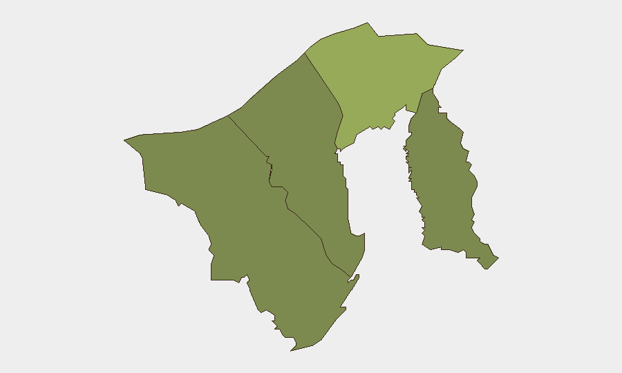
Brunei-Muara District (composite risk score 45) dominates the sub-national ranking and likely reflects concentration of capital infrastructure, foreign population, and transport hubs subject to immigration checks. Tutong District (20) presents secondary risk, while Belait (15) and Temburong (10) remain substantially lower. The ranking aligns with enforcement activity observed this week; heightened immigration and labour operations in Bandar Seri Begawan and Seria suggest risk scoring reflects operational intensity and foreign-worker density rather than unrest or instability.
How GeoBit Would Assist
Security teams monitoring Brunei should employ OSINT Fusion & Corroboration to track immigration and labour enforcement patterns across transport hubs and economic zones, paired with Intel Sweep and multi-language news monitoring to detect shifts in enforcement intensity or regulatory changes. AOI Monitoring & Early Warning on Brunei-Muara and Belait districts would provide persistent surveillance of enforcement activity, travel disruption, or environmental degradation. Environmental & Health monitoring would enable proactive assessment of transboundary haze impacts on business continuity and staff welfare.
7-Day Outlook
Immigration and labour enforcement operations are likely to continue at current baseline intensity. Haze conditions are expected to remain stable or improve absent new regional fire activity. No indicators suggest escalation toward unrest, travel restrictions, or supply-chain disruption in the near term.
Highest-Risk Areas — Ranked
| # | State / Region | Risk |
|---|---|---|
| 1 | Brunei-Muara District | 45 |
| 2 | Tutong District | 20 |
| 3 | Belait District | 15 |
| 4 | Temburong District | 10 |
Sources
Previous Weekly Briefs
A new Brunei brief is written every Monday, covering the week — each with its own risk map and downloadable CSV. Use the calendar to go further back.
- September 7, 2026
- August 31, 2026
- August 29, 2026
- August 26, 2026
- August 24, 2026
- August 22, 2026
- August 20, 2026
📅 Browse past briefs by calendar →
Highlighted days have a brief. Tap a day for that day's map & analysis, or “csv” for that day's dataset ($5).
Atlas — our AI intelligence desk — emails them this snapshot personally. Nothing else, no list.