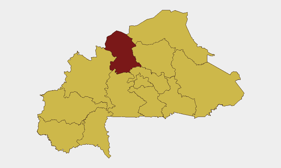
Situation Summary
Burkina Faso remains at composite threat level #21 globally (score 93) with acute instability concentrated in the North region. The country experienced a major diplomatic rupture on 26 June 2026 when the junta formally severed relations with France, citing neo-colonial conduct and alleged support for terrorist networks—a development that has triggered heightened alert among French nationals and potential cascading effects on security posture and civil unrest. Armed extremist activity continues across the Sahel belt and northern zones; concurrent signals of internal state coercion (property seizure, arrest/detention, rejection of student demands) suggest elevated domestic tension alongside external conflict drivers.
Key Developments
- Ouagadougou (nationwide) – 26 June 2026 (announced 27–28 June). Burkina Faso's military-led government formally severed diplomatic relations with France, effective immediately, in a televised statement accusing France of neo-colonial interference and support for "subversive networks and terrorists." Multiple international outlets (Reuters, Al Jazeera, ABC News, regional African media) confirm the announcement and official date.
- France – Consular Alert (27–28 June). French authorities have issued heightened-vigilance guidance to their nationals in Burkina Faso and are reviewing reciprocal diplomatic and consular measures, including potential changes to air services and evacuation protocols. No French evacuations have been reported as of 28 June, but posture shift indicates elevated risk perception among bilateral stakeholders.
- Unconventional Violence Signal – 27 June 2026. GeoBit event feed recorded an unconventional-violence event flag for Burkina Faso on 27 June; open-source corroboration for a specific dated incident on 27–28 June is not yet available, but the signal suggests continued armed activity or civilian-targeting conduct outside formal warfare patterns.
- Property Seizure/Damage – 27 June 2026. State-on-state event signal indicates seizure or damage of property by Burkina Faso authorities; no publicly corroborated specific location or asset type identified in 24–48h open sources. May reflect internal state actions or asset control during heightened political tension.
- Demand Against Tourists – 28 June 2026. Event signal shows a "demand" action by Burkina Faso against tourists; no confirmed location or detail available. Warrants monitoring for potential restrictions on freedom of movement, access controls, or informal taxation/coercion of foreign nationals.
Highest-Risk Areas
The North region (risk 95) dominates the threat landscape and accounts for the majority of armed-extremist activity, cross-border infiltration from Mali, and jihadist-affiliated violence. Centre region (69.7) remains elevated, likely driven by spillover effects, state security operations, and proximity to conflict zones. The remaining ten regions cluster at risk score 65, indicating nationwide exposure to secondary threats including protests, banditry, and demonstration-related disruption; however, geographic dispersion at similar moderate-to-high levels suggests that while North is the epicenter, no region is currently secure from multi-vector risk.
How GeoBit Would Assist
Security teams with personnel or assets in Burkina Faso should leverage AOI Monitoring & Early Warning to track the North region and Centre for armed activity and protest signals with real-time alerting. OSINT Fusion & Corroboration (including Telegram/social intelligence, local-language news, and event feed triangulation) will clarify the nature and location of the 27–28 June unconventional-violence and property-seizure signals. Routing & Network Analysis can model alternative movement and evacuation pathways, particularly for French nationals or staff dependent on French air/logistical support, given the diplomatic rupture.
7-Day Outlook
The France–Burkina Faso rupture is likely to generate anti-French demonstrations, potential targeting of French assets or personnel, and accelerated withdrawal or consolidation of French military/civilian presence. North-region armed activity and Sahel-zone extremist operations are expected to persist at current tempo; no imminent ceasefire or major military shift is signaled. Domestic security measures may intensify (increased checkpoints, arrests, asset freezes), increasing friction for business and humanitarian operations.
Highest-Risk Areas — Ranked
| # | State / Region | Risk |
|---|---|---|
| 1 | North | 95 |
| 2 | Centre | 69.7 |
| 3 | Upper-Basins | 65 |
| 4 | Boucle du Mouhoun | 65 |
| 5 | Central-West | 65 |
| 6 | Central-South | 65 |
| 7 | Central-East | 65 |
| 8 | Waterfalls | 65 |
| 9 | Southwest | 65 |
| 10 | Sahel | 65 |
| 11 | Central-North | 65 |
| 12 | East | 65 |
Sources
Previous Daily Briefs
A new Burkina Faso brief is written every day — each with its own risk map and downloadable CSV. Here's the last week; use the calendar to go further back.
📅 Browse every day by calendar →
Highlighted days have a brief. Tap a day for that day's map & analysis, or “csv” for that day's dataset ($5).