Situation Summary
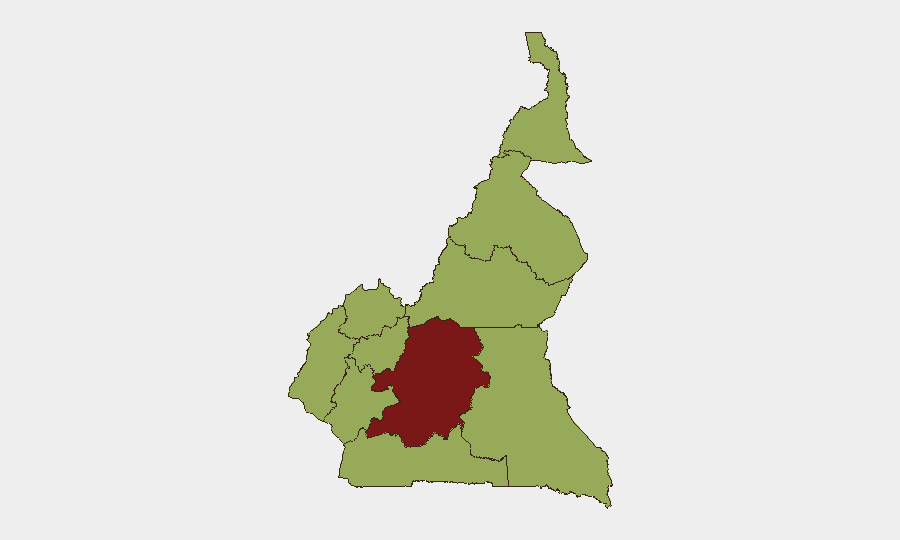
Cameroon faces a composite threat score of 74 (global rank #29), driven by active separatist insurgency in Anglophone regions, cross-border military tensions with Nigeria, and structural humanitarian stress in the Far North. The last 48 hours have surfaced both tactical escalation—unauthorized Cameroonian military incursion into Nigeria, IED activity in Southwest separatist zones—and systemic friction points including maritime registry violations and infrastructure delays tied to security constraints. The Centre region dominates risk (81.5), but Littoral, West, Northwest, and Southwest present elevated and sustained threats.
Key Developments
- Nigeria–Cameroon Border, Cross River Corridor (15–16 June): Over 200 Cameroonian soldiers conducted an unauthorized incursion into Abia community (Boki LGA, Cross River State, Nigeria), firing warning shots and triggering acknowledgment and response from Nigeria's 82 Division. Social media circulation of armed-troop footage has elevated border-zone alert levels among civilian populations.
- Manyu Division, Southwest Region (mid-June, reported last 48h): Separatist fighters were killed when an IED targeting Cameroonian military rotation detonated prematurely, confirming active explosive-device use and ongoing armed operational tempo in the Anglophone conflict zone.
- Yaoundé–Douala Motorway, Littoral Segment (mid-June, reported last 48h): The Minister of Public Works announced shift of construction activity toward Littoral due to "security bottlenecks in conflict zones," reflecting ongoing constraints on critical transport infrastructure and supply-chain predictability.
- Cameroon Maritime Registry (mid-June, reported last 48h): Cameroonian authorities launched a cleanup of the country's maritime registry following discovery of improperly flagged foreign vessels, likely to tighten compliance oversight and potentially disrupt or delay shipping operations.
- Far North Region Food Insecurity (mid-June, reported last 48h): The International Federation of Red Cross highlighted worsening food insecurity driven by rising prices, elevating humanitarian stress and potential triggers for localized crime or civil unrest in a region already under pressure.
Highest-Risk Areas
Centre region (81.5) remains the principal risk driver, encompassing the capital Yaoundé and surrounding corridors; it faces regime-stability dynamics, organized crime, and inter-communal tension. Northwest, Southwest, West, and Littoral (all 51.5) form a second tier, with Southwest and Northwest sustaining active Anglophone separatist operations, armed clashes with state forces, and IED activity. Far North and Adamawa (51.5) experience humanitarian crisis, Boko Haram residual activity, and cross-border spillover from Nigeria. The Nigeria–Cameroon border corridor is now an acute flashpoint following the 15–16 June incursion.
How GeoBit Would Assist
Teams with personnel or assets in Cameroon should deploy AOI Monitoring & Early Warning on Centre, Southwest, and the Nigeria–Cameroon border corridor to detect military movements, armed clashes, and roadblocks in near real-time. Conflict & Military battle mapping and force-structure tracking would clarify Cameroonian and separatist operational patterns and capability changes. Routing & Network Analysis can identify alternative supply and personnel routes around security bottlenecks on key motorways, while OSINT fusion across social media, local security pages, and cross-border reporting will provide early signals of tension escalation before formal incidents.
7-Day Outlook
The Nigeria–Cameroon border tension is likely to simmer through diplomatic channels, but risk of unintended escalation or further incursions remains elevated. Separatist activity in Southwest and Northwest will continue at current operational tempo; IED and ambush risk is persistent on military and civilian routes. Food-price pressure and humanitarian shortages in Far North may drive secondary crime and civil unrest within 7–10 days if no stabilization occurs.
Highest-Risk Areas — Ranked
| # | State / Region | Risk |
|---|---|---|
| 1 | Centre | 81.5 |
| 2 | Northwest | 53.4 |
| 3 | Southwest | 51.5 |
| 4 | West | 51.5 |
| 5 | Littoral | 51.5 |
| 6 | Adamawa | 51.5 |
| 7 | South | 51.5 |
| 8 | Far-North | 51.5 |
| 9 | North | 51.5 |
| 10 | East | 51.5 |
Sources
Previous Daily Briefs
A new Cameroon brief is written every day — each with its own risk map and downloadable CSV. Here's the last week; use the calendar to go further back.
📅 Browse every day by calendar →
Highlighted days have a brief. Tap a day for that day's map & analysis, or “csv” for that day's dataset ($5).