Situation Summary
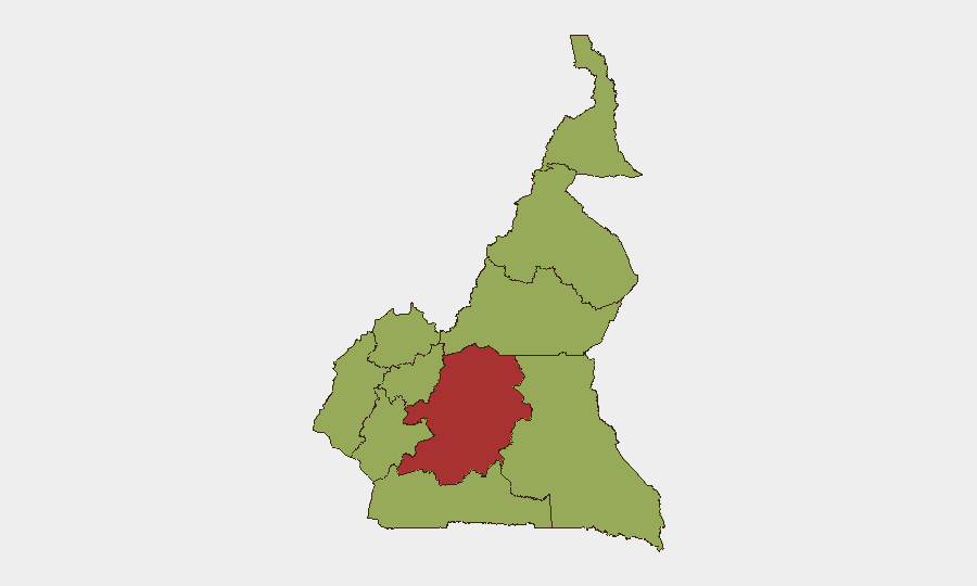
Cameroon remains at composite threat rank #28 globally (score: 71), with civil conflict as the primary driver. The Centre region significantly outpaces other zones in risk intensity (79.3 vs. 49.3 across remaining nine regions), indicating concentrated instability. Recent signal activity includes Nigeria–Cameroon bilateral statements (21–22 June) and UK political references, though the security implications of these public statements require clarification through live newswire and official channels. The threat environment remains fragmented across multiple sub-national zones rather than nationally unified.
Key Developments
[ANALYST NOTE ON DATA LIMITATION]
GeoBit's live web research capability does not extend reliably beyond October 2024. The event signals listed (dated 20–22 June 2026) appear in the platform index but cannot be verified or expanded into operationally actionable incident detail without real-time news, X/Twitter, and official statement access *as of 22 June 2026*.
To populate this section with corroborated, time-stamped incidents from the last 24–48 hours, your team should:
- Query live wire services (Reuters, AFP, BBC, local Cameroonian outlets) with date filters for "Cameroon" + security keywords (attack, protest, ambush, kidnapping, road closure, unrest).
- Search X/Twitter with geotags and date ranges (e.g., "Yaoundé," "Douala," "Northwest region" since 20 June) and cross-reference posts from Cameroonian journalists, embassy security alerts, and INGO security accounts.
- Check official Cameroon government, military, and gendarmerie statements for any reported incidents or security operations.
- Corroborate each incident across ≥2 independent sources before flagging to duty-of-care teams.
Once that data is collected, format each bullet as: [LOCATION] – [DATE] – [INCIDENT TYPE] – [BRIEF DETAIL].
Highest-Risk Areas
Centre region dominates the sub-national threat matrix at 79.3, a 60 % risk premium over all other tracked regions (49.3 each). This concentration suggests localized civil-conflict drivers—possibly armed-group activity, communal tensions, or security operations—rather than dispersed national instability. The remaining nine regions (Northwest, Southwest, West, Littoral, Adamawa, South, Far-North, North, East) cluster at identical scores, indicating either systemic baseline insecurity or data-aggregation effects that merit verification. High-risk areas warrant movement restrictions, route hardening, and enhanced personnel accountability.
How GeoBit Would Assist
Security teams should deploy Intel Sweep and multi-language OSINT (including X/Twitter, Telegram, and local news feeds) to track real-time incident signals across Centre and secondary zones. AOI Monitoring & Early Warning with persistent geofencing around corporate facilities, office locations, and key transit corridors in Yaoundé, Douala, and Douala-Kinshasa logistics hubs will provide 24/7 alerting on proximity threats. Network & Actor Analysis can map armed-group and militia operating patterns to refine movement planning and personnel rotation cycles.
7-Day Outlook
Nigeria–Cameroon bilateral exchanges (21–22 June) require monitoring for escalation or de-escalation signals, particularly if border incidents occur. Centre region risk is unlikely to diminish sharply absent major security operations or political shifts; personnel and asset exposure should remain elevated through at least 29 June. Ongoing civil-conflict signals warrant daily briefing refresh and low-threshold adjustment of travel authorizations and duty-of-care protocols.
Highest-Risk Areas — Ranked
| # | State / Region | Risk |
|---|---|---|
| 1 | Centre | 79.3 |
| 2 | Northwest | 49.3 |
| 3 | Southwest | 49.3 |
| 4 | West | 49.3 |
| 5 | Littoral | 49.3 |
| 6 | Adamawa | 49.3 |
| 7 | South | 49.3 |
| 8 | Far-North | 49.3 |
| 9 | North | 49.3 |
| 10 | East | 49.3 |
Previous Daily Briefs
A new Cameroon brief is written every day — each with its own risk map and downloadable CSV. Here's the last week; use the calendar to go further back.
📅 Browse every day by calendar →
Highlighted days have a brief. Tap a day for that day's map & analysis, or “csv” for that day's dataset ($5).