Situation Summary
Central African Republic remains a moderate-tier global security concern (rank #30, composite score 69) with fragmented instability concentrated in the northeast and along the DRC border. The past 24–48 hours show no cross-verified, newly documented security incidents in CAR territory, though event signals reflect ongoing tensions involving electoral bodies, banking sector disputes, and international diplomatic activity. Sub-national risk is heavily skewed toward Ouaka prefecture, which faces substantially elevated threat exposure compared to the capital and other regions.
Key Developments
- No new security incidents verified in last 24–48 hours. Open-source and social-media searches have not yielded cross-corroborated reports of fresh attacks, protests, infrastructure disruptions, or personnel security events in CAR in the 10–12 June window.
- Electoral and banking sector tension signals (10–12 June). The Central Election Commission and Central Bank have issued public statements and investigative moves; the Defense Ministry has made public statements to Human Rights Watch. These reflect institutional friction rather than imminent operational threat, but warrant monitoring for spillover into public order or foreign-national exposure.
- U.S. deportation/third-country migrant policy finalization (context: May–early June). CAR agreed to accept U.S. deportees; implementation discussions occurred in Bangui on 7 June. This does not present immediate ground-level risk but may increase informal-sector pressure and border-processing congestion in coming weeks.
- Iranian-CAR diplomatic tension flagged (12 June signal). A "threaten" event between Iranian and CAR entities was recorded; specific context and severity remain unclear from open sources and require monitoring for escalation.
- DRC public statement (12 June). The Democratic Republic of Congo issued a public statement, suggesting regional diplomatic or border activity; no specific incident documentation available.
Highest-Risk Areas
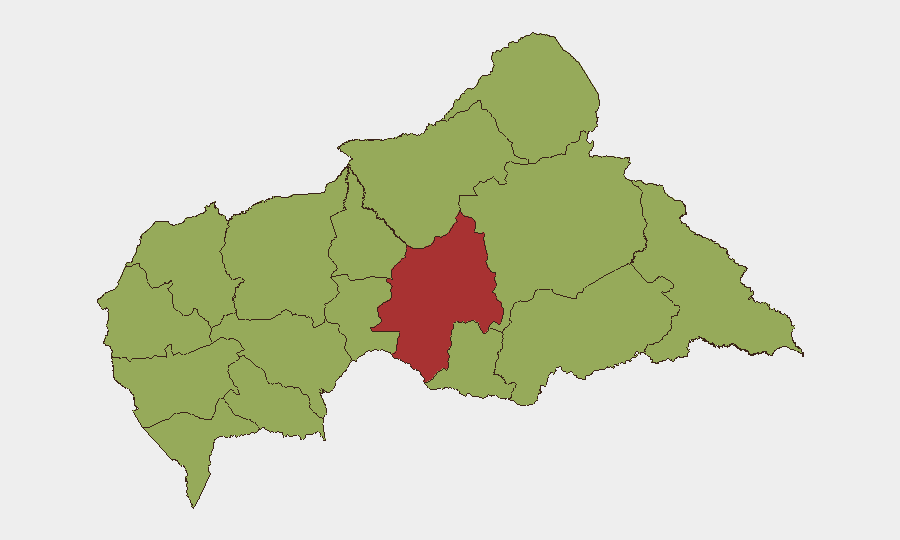
Ouaka prefecture dominates the risk landscape, with a composite score of 78.2—substantially higher than all other regions and nearly 1.5 times the capital's risk level. The remaining 11 prefectures cluster around 48.2, indicating a sharp geographic concentration of instability in the northeast. Bangui (51.5) represents secondary risk; its elevation reflects electoral tension, banking disputes, and as CAR's political and economic center, exposure to national-level shocks. The northeast corridor—Ouaka, Haute-Kotto, Haut-Mbomou, and Mbomou—forms a persistent vulnerability zone linked to transnational armed-group activity, porous borders with Chad and South Sudan, and limited state capacity. Organizations with personnel or assets outside Bangui should prioritize Ouaka and border-adjacent prefectures in security posture and contingency planning.
How GeoBit Would Assist
Security and duty-of-care teams should deploy AOI Monitoring & Early Warning on Ouaka and border regions to detect emerging clashes, displacement, or armed-group movement before they escalate. Entity & Network Analysis can track the actors behind the electoral and banking disputes to assess whether institutional tension poses risk to foreign nationals or supply chains. Conflict & Military intelligence coupled with OSINT fusion (X/Twitter, radio SIGINT, multi-language feeds) will provide real-time visibility into the Iranian diplomatic signal and DRC border posture, enabling rapid threat assessment if either develops into a security incident.
7-Day Outlook
No imminent spike in violence or civil unrest is evident in current signals. Electoral and banking-sector tensions should be monitored for public spillover, and the Iranian-CAR signal requires clarification to rule out escalation. Personnel and asset security posture in Ouaka and remote prefectures should remain elevated; the capital and southern regions present lower, baseline risk absent new triggers.
Highest-Risk Areas — Ranked
| # | State / Region | Risk |
|---|---|---|
| 1 | Ouaka | 78.2 |
| 2 | Bangui | 51.5 |
| 3 | Bamingui-Bangoran | 48.2 |
| 4 | Vakaga | 48.2 |
| 5 | Haute-Kotto | 48.2 |
| 6 | Haut-Mbomou | 48.2 |
| 7 | Mbomou | 48.2 |
| 8 | Nana-Mambéré | 48.2 |
| 9 | Ouham-Pendé | 48.2 |
| 10 | Mambéré-Kadéï | 48.2 |
| 11 | Sangha-Mbaéré | 48.2 |
| 12 | Ouham | 48.2 |
Sources
Previous Daily Briefs
A new Central African Republic brief is written every day — each with its own risk map and downloadable CSV. Here's the last week; use the calendar to go further back.
📅 Browse every day by calendar →
Highlighted days have a brief. Tap a day for that day's map & analysis, or “csv” for that day's dataset ($5).