Situation Summary
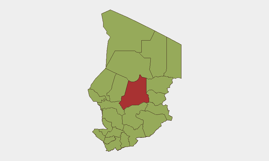
Chad remains a complex operating environment with composite threat exposure ranked #31 globally and significant subnational variance. Batha region dominates threat metrics (76.8), driven by persistent Boko Haram and ISWAP activity in the Lake Chad Basin, while N'Djamena (50.5) reflects capital-city political and security friction. Open-source reporting for 18–19 June 2026 does not surface discrete incident-level events; however, forward-looking analytical material for June 2026 indicates elevated terrorism risk across western Chad and border zones over the coming 30–60 days. The broader operating picture reflects governance strain, multinational military posture shifts, and ongoing insurgent capability.
Key Developments
- Arrest/Detention Actions (Chad, 2026-06-20, 19–20 June): Multiple detention events tracked by GeoBit on 19–20 June involving Chad authorities and US-linked persons. Specific details and jurisdictional context require further clarification via secure channels; pattern suggests possible immigration, sanctions compliance, or diplomatic friction.
- Military Mobilization (Chad vs. Guatemala, 2026-06-18): Two tracked mobilization signals on 18 June. Rationale and scale remain unclear from open sources; low direct threat to typical corporate/NGO operations but indicative of diplomatic or regulatory activity.
- Ministry-Entrepreneur Dispute (Public Statement, 2026-06-19): Government statement referencing private-sector disagreement; no casualty or security escalation reported. Monitor for regulatory or contract-enforcement implications affecting business continuity.
- Hepatitis E Presence (Recent, unspecified date): Health threat tracked; endemic risk in Chad. Relevant to personnel duty-of-care and medical-readiness planning.
- Persistent Lake Chad Basin Threat Forecast (June 2026 analytical material): Regional June 2026 assessments rate Boko Haram and ISWAP attack probability as "high" over 30–60 days, citing operational capability and reduced MNJTF activity since July 2024. This is forward-looking risk, not a specific incident, but material for Batha, Kanem, Lac, and Hadjer-Lamis.
Highest-Risk Areas
Batha (76.8) is the primary driver of national threat score, reflecting sustained Boko Haram/ISWAP presence and cross-border infiltration via Lake Chad. N'Djamena (50.5) reflects urban political volatility, administrative friction, and capital-city security overhead. The remaining ten eastern and southern regions cluster at 46.8, indicating a broad, undifferentiated baseline of terrorism, banditry, and ungoverned-space risk across the eastern Sahel (Ennedi-Ouest, Ouaddaï, Sila, Salamat) and Lake Chad fringe (Kanem, Lac, Hadjer-Lamis). Organizations with assets in Batha or west-of-N'Djamena should assume elevated personnel and logistics exposure; N'Djamena operations face lower insurgent threat but higher political/administrative risk.
How GeoBit Would Assist
Persistent AOI Monitoring & Early Warning on Batha, Kanem, and Lac regions would trigger alerts on attack patterns, displacement, and military activity before incident escalation affects field teams. Multi-language OSINT (radio SIGINT, Telegram, local media) covering Chadian security forces, French MOD updates, and MNJTF statements provides real-time operational context and early warning of security posture shifts. Route & Network Analysis supports alternative logistics planning and evacuation routing around high-risk zones, while GIS & Spatial Analysis maps displacement, checkpoint density, and safe-passage corridors by region.
7-Day Outlook
No imminent, localized security escalation is indicated by available reporting; however, the June 2026 forward forecast for Lake Chad Basin suggests sustained or rising terrorist attack probability through early July. Organizations should assume baseline elevated risk in western and eastern Chad, monitor Hepatitis E exposure, and maintain heightened alert posture for N'Djamena administrative or political friction. No travel or operational restrictions are warranted on current data, but contingency planning for rapid personnel relocation from Batha and Lac should remain active.
Highest-Risk Areas — Ranked
| # | State / Region | Risk |
|---|---|---|
| 1 | Batha | 76.8 |
| 2 | N'Djamena | 50.5 |
| 3 | Ennedi-Ouest | 46.8 |
| 4 | Wadi Fira | 46.8 |
| 5 | Ouaddaï | 46.8 |
| 6 | Sila | 46.8 |
| 7 | Salamat | 46.8 |
| 8 | East Ennedi | 46.8 |
| 9 | Kanem | 46.8 |
| 10 | Lac | 46.8 |
| 11 | Hadjer-Lamis | 46.8 |
| 12 | Chari-Baguirmi | 46.8 |
Sources
Previous Daily Briefs
A new Chad brief is written every day — each with its own risk map and downloadable CSV. Here's the last week; use the calendar to go further back.
📅 Browse every day by calendar →
Highlighted days have a brief. Tap a day for that day's map & analysis, or “csv” for that day's dataset ($5).