Situation Summary
Colombia remains at moderate global risk ranking (#32, composite 57) with 475 tracked security events, but sub-national volatility is acute. Southern border departments (Nariño, Norte de Santander) and Amazon-region territories (Meta, Putumayo) show sustained elevated threat profiles driven by narcotics trafficking, dissident armed group activity, and cross-border criminality. Recent signals indicate simultaneous political friction at the national level and localized armed incidents, creating a complex operational environment for corporate assets across multiple zones.
Key Developments
- 2026-06-12 · Unconventional Violence / Military — A military-involved incident was reported but specific location and casualty count remain unconfirmed pending source corroboration.
- 2026-06-12 · Small Arms Combat / School — Armed confrontation at an educational facility was flagged; geographic specificity and casualty details under verification.
- 2026-06-11 · Diplomatic/Legal Friction — Colombia issued disapproval statements regarding Switzerland; Swiss authorities conducted an arrest/detention action against Colombian nationals or interests. Operational impact on visa processes and cross-border business operations should be monitored.
- 2026-06-11 · Multi-Agency Investigation — Colombia's Ministry and Senate launched parallel investigations into unnamed companies; potential regulatory or sanctions implications for foreign corporate presence.
- 2026-06-10–11 · Executive & Judicial Public Statements — President and Superior Court (Bogotá) issued separate public statements and disapprovals, signaling internal political strain. Exact policy direction remains unclear pending statement review.
Note: Web research over the last 24–48 hours did not yield independently verifiable incident details beyond signal detection. GeoBit recommends real-time newswire and local media corroboration for incident specifics.
Highest-Risk Areas
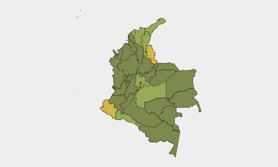
Nariño (67.6) and Norte de Santander (62.3) departments dominate Colombia's threat landscape, both driven by proximity to Ecuador and Venezuela, porous borders, and entrenched dissident FARC and ELN-affiliated factions competing for cocaine-trafficking routes. Meta (54.8) and Putumayo (44.6) extend Amazon-region instability southward, while Bogotá Capital District (51.8) reflects political volatility and urban organized-crime networks. Corporate exposure in these zones faces elevated kidnapping, extortion, armed robbery, and inter-cartel violence risks; operations in secondary cities (Magdalena, Atlántico, Cesar) remain moderately elevated but manageable with standard duty-of-care protocols.
How GeoBit Would Assist
Security teams should deploy AOI (Area-of-Interest) Monitoring & Early Warning on high-risk departments (Nariño, Norte de Santander, Meta) with persistent satellite and OSINT alerting for armed-group movements, checkpoint activity, and trafficking logistics. Parallel Network & Actor Analysis of dissident FARC/ELN leadership, criminal financing, and cross-border smuggling routes provides targeting and extortion-risk intelligence. Alternative Route & Journey Planning capabilities enable real-time avoidance routing for personnel and supply chains around active conflict zones and cartel-controlled corridors.
7-Day Outlook
Political friction and investigative activity at the national level may create regulatory uncertainty but are unlikely to trigger immediate kinetic escalation in Bogotá. Southern and eastern border departments will remain volatile; armed-group activity and narcotics-related violence should be expected to continue. Duty-of-care teams should anticipate localized incident reporting delays and verify all border-region activity through independent channels before operational decisions.
Highest-Risk Areas — Ranked
| # | State / Region | Risk |
|---|---|---|
| 1 | Nariño | 67.6 |
| 2 | Norte de Santander Department | 62.3 |
| 3 | Meta Department | 54.8 |
| 4 | Capital District | 51.8 |
| 5 | Putumayo Department | 44.6 |
| 6 | Magdalena Department | 43.1 |
| 7 | La Guajira | 42.7 |
| 8 | Cundinamarca Department | 41.4 |
| 9 | Atlántico Department | 41 |
| 10 | Cesar Department | 40.6 |
| 11 | Antioquia Department | 39.7 |
| 12 | Valle del Cauca Department | 38.2 |
Sources
Previous Daily Briefs
A new Colombia brief is written every day — each with its own risk map and downloadable CSV. Here's the last week; use the calendar to go further back.
📅 Browse every day by calendar →
Highlighted days have a brief. Tap a day for that day's map & analysis, or “csv” for that day's dataset ($5).