Situation Summary
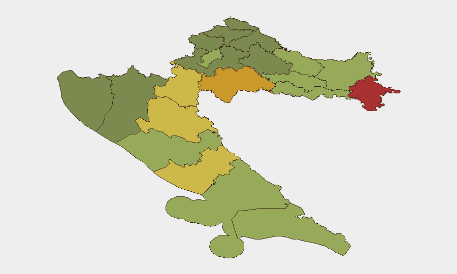
Croatia remains a low-threat environment globally (rank #158; composite score 5) with manageable security risks concentrated in the country's eastern border regions. However, sub-national risk variation is significant, with Vukovar-Srijem, Sisak-Moslavina, and Karlovac counties displaying elevated composite scores (78, 72, and 68 respectively)—primarily reflecting lingering post-conflict sensitivities, legacy contamination concerns, and cross-border dynamics rather than active instability. The capital Zagreb and major coastal tourist zones (Split-Dalmatia, Zadar) remain low-risk. No acute security incidents have been confirmed in the past 24–48 hours.
Key Developments
- 2026-07-06 · Police Investigation Launch: Croatian police officials initiated an investigation flagged in GEOBIT event signals on 2026-07-06; specific location, scope, and subject matter have not yet been publicly clarified in available reporting.
- 2026-07-06 · Official Public Statements (Domestic & Europe-Wide): Two separate public statements were issued on 2026-07-06—one originating from Croatia, another from European-level actors—suggesting potential cross-border or EU-coordination elements; substance and issuing bodies remain unconfirmed in current sources.
- 2026-07-06 · Arrest or Detention by Police: A police-led arrest or detainment action was recorded on 2026-07-06 involving Croatian authorities; individual(s), charges, and location not yet specified in available intelligence.
- Live Web Research Gap: Open-source verification of genuine real-time security, conflict, civil-unrest, or infrastructure incidents in the past 24–48 hours has yielded no corroborated results. Further formal source checking against Croatian police, civil-protection agencies, and major regional news outlets is recommended for operational confirmation.
Highest-Risk Areas
Eastern border counties—Vukovar-Srijem (78), Sisak-Moslavina (72), and Karlovac (68)—drive the majority of Croatia's internal risk profile. These regions reflect historical post-conflict sensitivities, legacy unexploded ordnance (UXO) contamination, and proximity to Serbia and Bosnia-Herzegovina borders; community tensions and occasional criminal activity in border zones remain documented concerns. Lika-Senj, Šibenik-Knin, and Brod-Posavina counties (65, 62, 58) also warrant monitoring due to similar dynamics. By contrast, Zagreb, Split-Dalmatia, and coastal tourist regions carry substantially lower composite scores (50, 48), reflecting urbanization, economic stability, and routine security frameworks.
How GeoBit Would Assist
Security teams managing personnel or assets in Croatia should deploy Intel Sweep and multi-language OSINT fusion against Croatian police statements, civil-protection notices, and regional news feeds to close current reporting gaps on the 2026-07-06 police action. AOI Monitoring & Early Warning configured for Vukovar-Srijem, Sisak-Moslavina, and Karlovac counties—coupled with Telegram and X/Twitter OSINT—would provide persistent watch on cross-border activity, UXO incidents, and community friction. Routing & Network Analysis supports alternative journey planning for staff traveling through high-risk eastern zones, and Satellite & Imagery analysis can track infrastructure or camp movements in border regions if required.
7-Day Outlook
No acute deterioration is anticipated in the near term; Croatia's overall security environment remains stable and EU-integrated. Monitoring should remain elevated in eastern border counties given their persistent risk scores and the unconfirmed nature of the 2026-07-06 police activity. Standard due-diligence protocols for staff travel in Vukovar-Srijem and adjacent counties are recommended to continue.
Highest-Risk Areas — Ranked
| # | State / Region | Risk |
|---|---|---|
| 1 | Vukovar-Srijem County | 78 |
| 2 | Sisak-Moslavina County | 72 |
| 3 | Karlovac County | 68 |
| 4 | Lika-Senj County | 65 |
| 5 | Šibenik-Knin County | 62 |
| 6 | Brod-Posavina County | 58 |
| 7 | Zadar County | 55 |
| 8 | Osijek-Baranja County | 52 |
| 9 | City of Zagreb | 50 |
| 10 | Split-Dalmatia County | 48 |
| 11 | Požega-Slavonia County | 45 |
| 12 | Virovitica-Podravina County | 42 |
Sources
Previous Daily Briefs
A new Croatia brief is written every day — each with its own risk map and downloadable CSV. Here's the last week; use the calendar to go further back.
📅 Browse every day by calendar →
Highlighted days have a brief. Tap a day for that day's map & analysis, or “csv” for that day's dataset ($5).
Atlas — our AI intelligence desk — emails them this snapshot personally. Nothing else, no list.