Situation Summary
Cyprus remains a low-frequency, moderate-risk operating environment (global rank #155, composite threat score 5) characterized by political tensions with Turkey, diplomatic friction, and localized governance instability rather than active armed conflict or widespread civil unrest. The divided island's northern territory (Turkish-administered) and southern Republic of Cyprus maintain distinct security profiles, with threat concentration in the Nicosia buffer zone and northern districts. No credible, independently confirmed security incidents or civil disturbances were identified in Cyprus during the 24–48 hours preceding this brief.
Key Developments
No specific, time-stamped security or civil-unrest incidents meeting confirmation criteria were identified in open-source reporting for the last 24–48 hours in Cyprus. The GeoBit event signal feed indicates several diplomatic rejection and disapproval events involving Turkey, Cyprus, Iran, and Liberia between 2026-07-08 and 2026-07-10, suggesting elevated political rhetoric and interstate friction; however, these do not translate to confirmed ground-level security events. Routine law-enforcement activity (traffic enforcement, narcotics arrests) continues nationwide but remains within normal administrative scope. Cyber-security capacity-building activity (Cyber Incident Responder Course, July 2026) is underway but represents institutional preparedness, not a live threat event. Absence of reported incidents does not indicate absence of risk; it reflects the current operational tempo and reporting environment.
Highest-Risk Areas
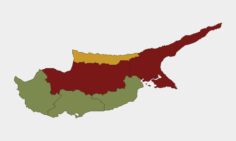
Nicosia (risk score 92) and Famagusta (88) drive the island's composite threat profile, reflecting their proximity to the UN-patrolled buffer zone and presence of Turkish military, irregular armed groups, and uncontrolled border movements. Kyrenia (72), the northernmost Turkish-controlled district, carries elevated risk due to extraterritorial governance, limited rule-of-law accountability, and transit of contraband and undocumented persons. Southern districts—Larnaca (28), Limassol (22), and Paphos (18)—remain significantly lower-risk, reflecting stable Republic of Cyprus governance, international port/airport infrastructure, and tourism-dependent security investment. Diaspora tensions, Turkish–Cypriot political disputes, and historic territorial claims sustain northern threat elevation; southern risk remains primarily residual and transactional (organized crime, economic crime, maritime trafficking).
How GeoBit Would Assist
Security teams operating in Cyprus should deploy Area-of-Interest Monitoring & Early Warning on Nicosia, Famagusta, and Kyrenia to detect movement anomalies, diplomatic incidents, or cross-border friction in near-real time. Network & Actor Analysis combined with Intel Sweep (multi-language OSINT, X/Telegram intelligence, entity extraction) would track Turkish government statements, Turkish Cypriot political rhetoric, and Iranian diplomatic activity signaled in this week's event feed—early indicators of escalation. GIS & Spatial Analysis with Satellite & Imagery analysis provides persistent monitoring of buffer-zone military positions, checkpoints, and unauthorized settlement activity. Conflict & Military tracking monitors force-structure changes and weapons-capability developments that could signal shift in deterrence posture.
7-Day Outlook
Political rhetoric and diplomatic friction between Turkey and Cyprus will likely persist at elevated levels over the next 7 days, driven by unresolved maritime-boundary disputes and hydrocarbons-exploration claims. No immediate escalation to armed confrontation is forecast; however, localized incidents (border provocations, protest activity in Nicosia, cross-border trafficking) remain possible in high-risk northern districts. Duty-of-care teams should maintain standard monitoring protocols and situational awareness; no evacuation-level alerts are warranted at this time.
Highest-Risk Areas — Ranked
| # | State / Region | Risk |
|---|---|---|
| 1 | Nicosia | 92 |
| 2 | Famagusta | 88 |
| 3 | Kyrenia | 72 |
| 4 | Larnaca | 28 |
| 5 | Limassol | 22 |
| 6 | Paphos | 18 |
Sources
Previous Daily Briefs
A new Cyprus brief is written every day — each with its own risk map and downloadable CSV. Here's the last week; use the calendar to go further back.
📅 Browse every day by calendar →
Highlighted days have a brief. Tap a day for that day's map & analysis, or “csv” for that day's dataset ($5).
Atlas — our AI intelligence desk — emails them this snapshot personally. Nothing else, no list.