Situation Summary
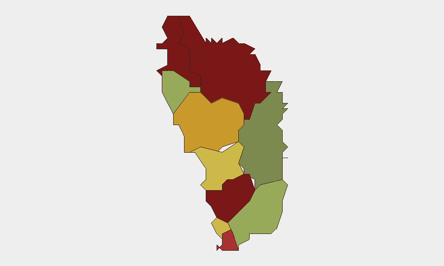
Dominica presents a low acute security environment as of 2 August 2026, with no confirmed discrete incidents of civil unrest, conflict, major crime, infrastructure disruption, or travel risk reported in the last 24–48 hours. The national composite threat score remains at 2, reflecting baseline Caribbean risk conditions. Sub-national variance is significant, however, with Saint Andrew Parish (risk 92) and Saint John Parish (risk 88) substantially elevated relative to safer parishes such as Saint David (risk 35), suggesting concentrated vulnerability in specific administrative zones rather than nationwide instability.
Key Developments
- Countrywide – 29–30 July 2026: Consolidated threat assessment confirms no substantiated incidents of civil unrest, conflict, or infrastructure disruption in the 24–48-hour window; acute security risk classified as low across all reviewed news, social, and regional sources.
- Countrywide – circulating unverified claim: Social media posts (X/Twitter) allege a nationwide "State of Emergency" and curfew; no government announcement, regional news corroboration, or confirmed timing exists. Threat intelligence explicitly recommends treating this as an uncorroborated lead pending official verification.
- Dominica travel baseline (ongoing, not incident-specific): UK Foreign Office advisory notes low crime rates and occasional protests/demonstrations as part of standard country profile; no new protests or tear-gas incidents flagged in the current 24–48-hour window.
- Regional/local news feeds – 24–48h check: Major Caribbean news aggregators and Dominica-focused outlets report routine political and community news; no new civil unrest, crime spikes, or travel-disrupting incidents identified.
Highest-Risk Areas
Saint Andrew Parish and Saint John Parish significantly exceed national threat baselines, with composite scores of 92 and 88 respectively, indicating concentrated vulnerability in these administrative divisions. Saint George Parish (81) and Saint Mark Parish (78) also warrant heightened monitoring. The disparity between high-risk and low-risk parishes (Saint David at 35) suggests that risk drivers—whether crime, infrastructure vulnerability, governance capacity, or other factors—are geographically non-uniform and merit parish-level rather than national-only security posture adjustment.
How GeoBit Would Assist
Security teams with personnel or assets in Dominica should employ AOI (Area-of-Interest) Monitoring & Early Warning on Saint Andrew and Saint John parishes to detect emerging civil unrest, crime clusters, or infrastructure failures before they escalate. Intel Sweep and multi-language OSINT fusion (X/Twitter, Telegram, local news feeds, social sentiment analysis) will disambiguate unconfirmed rumors—such as the circulating "State of Emergency" claim—from confirmed government or credible-media announcements. Risk & Threat Assessment and Routing & Network Analysis enable duty-of-care teams to adjust staffing deployments, travel authorizations, and alternative response routes based on parish-level risk variance.
7-Day Outlook
No imminent acute threat indicators are present; the security environment is expected to remain stable over the next 7 days absent new discrete triggering events. Monitoring should remain elevated in Saint Andrew and Saint John parishes and should closely track official government communications channels and regional news feeds to rapidly confirm or rule out the unverified "State of Emergency" claim. Standard Caribbean-baseline vigilance regarding occasional demonstrations and localized crime is appropriate.
Highest-Risk Areas — Ranked
| # | State / Region | Risk |
|---|---|---|
| 1 | Saint Andrew Parish | 92 |
| 2 | Saint John Parish | 88 |
| 3 | Saint George Parish | 81 |
| 4 | Saint Mark Parish | 78 |
| 5 | Saint Joseph Parish | 72 |
| 6 | Saint Paul Parish | 68 |
| 7 | Saint Luke Parish | 62 |
| 8 | Saint Peter Parish | 55 |
| 9 | Saint Patrick Parish | 48 |
| 10 | Saint David Parish | 35 |
Sources
Previous Daily Briefs
A new Dominica brief is written every day — each with its own risk map and downloadable CSV. Here's the last week; use the calendar to go further back.
📅 Browse every day by calendar →
Highlighted days have a brief. Tap a day for that day's map & analysis, or “csv” for that day's dataset ($5).
Atlas — our AI intelligence desk — emails them this snapshot personally. Nothing else, no list.