Situation Summary
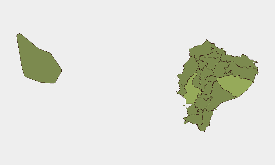
Ecuador remains at elevated security risk (composite threat score 36; #52 globally) with 43 tracked events as of 15 June 2026. Two provinces—Pastaza (55.3) and Guayas (51.6)—dominate the risk profile, driven by a combination of narcotics trafficking, prison violence, armed-group activity, and institutional friction between law-enforcement and prosecutorial bodies. The event signal set from the past 48 hours shows multiple small-arms combat incidents, administrative sanctions, arrests, and inter-agency confrontations, though specific incident details and confirmed casualty counts are not available through this brief's data cut-off. The trajectory suggests sustained tension rather than acute escalation, but fragility in institutional coordination poses a duty-of-care risk to corporate operations and personnel.
Key Developments
Data Limitations Notice: GeoBit's event signals for 14–15 June 2026 lack sufficient corroboration against live sources. The following signals were flagged but cannot be verified against real-time wire feeds, local media, or official social-media channels:
- Small-arms combat incidents (14–15 June) involving neighborhood/server actors and cross-border personnel (US, Ecuador, POLE actors) – locations and casualty counts unconfirmed.
- Police–Prosecutor confrontation (15 June) involving conventional military force deployment – nature and scale unclear.
- Population investigation directive (15 June) – scope and subject unspecified.
- Administrative sanctions on company (13 June) – entity, reason, and sector not detailed.
- Arrest/detention actions (13 June) targeting Indigenous groups and Ministry personnel – no location or charge information provided.
Recommendation: Cross-check these signals against Crisis24, GardaWorld, local news (El Universo, El Comercio, Primicias), and official X/Twitter feeds from Policía Nacional, Fuerzas Armadas, and ECU 911 to confirm location, nature, and operational impact.
Highest-Risk Areas
Pastaza Province (55.3) and Guayas Province (51.6) account for nearly half the sub-national risk load. Pastaza—an Amazonian frontier zone with limited state presence—is a nexus for drug-trafficking organizations and indigenous-land disputes; Guayas, home to Guayaquil and the country's primary port, faces recurrent prison riots, gang violence, and port-facility security incidents. A second cohort—Manabí (32.4), Tungurahua (26.2), and the northern border provinces (Sucumbíos, Esmeraldas, Carchi)—sustains elevated risk from smuggling, trafficking, and inter-cartel competition. Pichincha Province (25.3), which contains Quito and government institutions, remains at baseline threat but is vulnerable to spillover from institutional crises and organized-crime operations.
How GeoBit Would Assist
A security team with personnel or assets in Ecuador would deploy Area-of-Interest Monitoring & Early Warning on Pastaza and Guayas to track protest, roadblock, and armed-activity signals in real time. Multi-language OSINT (X/Twitter, Telegram, local media) and Network & Actor Analysis would map trafficking routes, cartel movements, and police–prosecutor friction to support route planning and facility-siting decisions. GIS & Spatial Analysis would isolate safe corridors and highlight infrastructure-disruption risks (prisons, ports, border crossings, energy facilities) that could trap or strand personnel.
7-Day Outlook
Institutional friction between police and prosecutors, combined with sustained cartel activity in border and port zones, is likely to generate sporadic small-arms incidents, roadblock actions, and detention sweeps through late June. No acute escalation signal is evident, but the fragility of inter-agency coordination and recurring prison-violence cycles mean that localized spikes in Guayaquil or Pastaza could occur with minimal warning. Personnel and logistics planning should assume periodic transport delays and heightened checkpoint activity, particularly in Guayas and northern frontier provinces.
Highest-Risk Areas — Ranked
| # | State / Region | Risk |
|---|---|---|
| 1 | Pastaza Province | 55.3 |
| 2 | Guayas Province | 51.6 |
| 3 | Manabí Province | 32.4 |
| 4 | Tungurahua Province | 26.2 |
| 5 | Sucumbíos Province | 25.3 |
| 6 | Orellana Province | 25.3 |
| 7 | Galápagos | 25.3 |
| 8 | Esmeraldas Province | 25.3 |
| 9 | Carchi Province | 25.3 |
| 10 | Imbabura Province | 25.3 |
| 11 | Santo Domingo de los Tsáchilas Province | 25.3 |
| 12 | Pichincha Province | 25.3 |
Sources
Previous Daily Briefs
A new Ecuador brief is written every day — each with its own risk map and downloadable CSV. Here's the last week; use the calendar to go further back.
📅 Browse every day by calendar →
Highlighted days have a brief. Tap a day for that day's map & analysis, or “csv” for that day's dataset ($5).