Situation Summary
Gabon remains a low-threat environment with a composite national risk score of 19 (rank #61 globally). Open-source security monitoring detected no confirmed incidents, civil unrest, conflict, or infrastructure disruptions in the last 24–48 hours. National-level operations—including Libreville International Airport and newly activated Air Algérie connectivity—are proceeding normally. Risk remains concentrated in the northeastern border region rather than the capital or major economic zones.
Key Developments
- No verified security incidents in Gabon (last 48 hours). Live web research, news feeds, and social-media monitoring across multiple languages and platforms returned no multi-source–confirmed events meeting security-alert criteria (conflict, unrest, crime, infrastructure failure, or travel disruption) as of 2026-06-26.
- Libreville International Airport – normal operations. Air Algérie's newly inaugurated Algiers–Douala–Libreville service (launched 23 June 2026) continues operating without reported security incidents or passenger/cargo disruptions through 25–26 June.
- National infrastructure baseline stable. Port and potash-export infrastructure shows no active incidents, blockades, or strikes in the reporting period; structural supply-chain and geopolitical vulnerabilities remain under observation but are not acute.
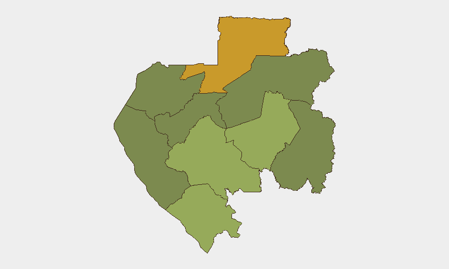
- Woleu-Ntem Province remains elevated-risk zone. Northeastern border region (composite risk 72) continues to drive national sub-national rankings; no new acute incidents logged in last 48 hours, but persistent factors warrant monitoring.
Highest-Risk Areas
Woleu-Ntem Province (risk 72) and Ogooué-Lolo Province (risk 58) account for the majority of Gabon's tracked sub-national risk. Woleu-Ntem's northeastern location, bordering Cameroon and Equatorial Guinea, reflects historical cross-border movement, informal trade networks, and limited state capacity; Ogooué-Lolo's interior position and resource-extraction activity generate secondary vulnerability. Ngounié, Nyanga, and Haut-Ogooué provinces show moderate residual risk (35–48), while Estuaire (capital region; risk 15) and Ogooué-Ivindo remain low-risk. Duty-of-care teams with assets in the north should maintain heightened awareness; Libreville and southern coastal zones present materially lower exposure.
How GeoBit Would Assist
Security teams operating in Gabon should leverage AOI Monitoring & Early Warning on Woleu-Ntem and Ogooué-Lolo to detect emerging civil unrest, border-crossing anomalies, or resource-sector disruptions before they escalate. Intel Sweep and multi-language OSINT (including X/Telegram, radio SIGINT, and local news feeds) provide continuous low-noise situational awareness, critical given limited mainstream media coverage of remote northeastern incidents. Routing & Network Analysis supports alternative-path planning for staff or supply chains transiting high-risk provinces, while Satellite & Imagery analysis can corroborate or contextualize border-region activity when ground reporting is sparse.
7-Day Outlook
No major escalation is anticipated over the next seven days; Gabon's security posture is expected to remain stable, with routine operations continuing at national ports, airports, and capital-region government functions. Persistent low-level risk in the northeast warrants continued passive monitoring but does not warrant operational constraint. Duty teams should maintain standard vigilance on staff movement in Woleu-Ntem and maintain emergency-contact protocols.
Highest-Risk Areas — Ranked
| # | State / Region | Risk |
|---|---|---|
| 1 | Woleu-Ntem | 72 |
| 2 | Ogooué-Lolo Province | 58 |
| 3 | Ngounié Province | 48 |
| 4 | Nyanga Province | 42 |
| 5 | Haut-Ogooué Province | 35 |
| 6 | Moyen-Ogooué Province | 28 |
| 7 | Ogooué-Maritime Province | 25 |
| 8 | Estuaire Province | 15 |
| 9 | Ogooué-Ivindo | 0 |
Sources
Previous Daily Briefs
A new Gabon brief is written every day — each with its own risk map and downloadable CSV. Here's the last week; use the calendar to go further back.
📅 Browse every day by calendar →
Highlighted days have a brief. Tap a day for that day's map & analysis, or “csv” for that day's dataset ($5).