Situation Summary
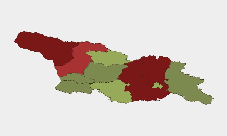
Georgia remains a low-threat environment globally (rank #111, composite score 11) with no tracked security events in the past 24–48 hours. However, the country's risk profile is sharply divided: northern and central regions bordering Russian-occupied territories—particularly Abkhazia (risk 95), Shida Kartli (88), and Lower Kartli (85)—face sustained geopolitical and conflict-adjacent pressures, while southern and western regions remain significantly safer. Recent flood events underscore the secondary hazard landscape. Overall trajectory is stable but regionally polarized.
Key Developments
No security incidents were identified in Georgia during the last 24–48 hours. Flood monitoring remains active (event reference 1103959, date unspecified); teams with assets in flood-prone lowlands and drainage zones should confirm local weather and water authority updates. The absence of tracked events reflects the current operational calm in major population centers and transit corridors, but does not indicate reduced baseline risk in disputed or border-adjacent territories.
Highest-Risk Areas
The top five regions drive nearly all elevated risk: Abkhazia and Shida Kartli account for the steepest threat scores, driven by unresolved territorial disputes, Russian military presence, and restricted access. Lower Kartli and Mtskheta-Mtianeti follow, reflecting proximity to the South Ossetia border zone and mountain-terrain vulnerabilities. Samegrelo-Upper Svaneti (risk 78) adds complexity due to geographic isolation and limited state authority in remote areas. By contrast, Tbilisi (risk 45) and the southern autonomous republics (Adjara 35, Guria 28) maintain substantially lower risk profiles. Organizations with personnel or supply chains in the north should treat movement and communications as restricted and contingency-dependent; southern operations face routine, manageable commercial risks.
How GeoBit Would Assist
Three capabilities are operationally critical for Georgia duty-of-care teams: (1) AOI Monitoring & Early Warning to maintain persistent watch on Abkhazia, South Ossetia border zones, and key transit corridors, with automated alerting on military activity, protests, or access restrictions; (2) Conflict & Military tracking (force structure, weapons-capability monitoring, battle mapping) to detect escalation signals in disputed territories before they impact expatriate or supply-chain safety; (3) Routing & Network Analysis to pre-plan and maintain alternative journey routes around high-risk northern zones, with real-time feasibility assessment as conditions shift. Intel Sweep and multi-language OSINT monitoring of local government, security agency, and regional media sources provide early indicators of administrative closures or localized incidents.
7-Day Outlook
No acute threats are forecast over the next seven days. Seasonal flood risk remains embedded, particularly in lower-lying regions; weather monitoring should remain routine. The broader geopolitical backdrop—Russian military presence in disputed territories and periodic tensions along the de facto borders—remains static but poses latent risk to any unplanned movement into northern zones. Organizations should maintain current duty-of-care protocols and monitor border-area advisories weekly.
Highest-Risk Areas — Ranked
| # | State / Region | Risk |
|---|---|---|
| 1 | Autonomous Republic of Abkhazia | 95 |
| 2 | Shida Kartli | 88 |
| 3 | Lower Kartli | 85 |
| 4 | Mtskheta-Mtianeti | 82 |
| 5 | Samegrelo-Upper Svaneti | 78 |
| 6 | Samtskhe-Javakheti | 48 |
| 7 | Tbilisi | 45 |
| 8 | Racha-Lechkhumi and Kvemo Svaneti | 42 |
| 9 | Kakheti | 38 |
| 10 | Autonomous Republic of Adjara | 35 |
| 11 | Imereti | 32 |
| 12 | Guria | 28 |
Sources
Previous Daily Briefs
A new Georgia brief is written every day — each with its own risk map and downloadable CSV. Here's the last week; use the calendar to go further back.
📅 Browse every day by calendar →
Highlighted days have a brief. Tap a day for that day's map & analysis, or “csv” for that day's dataset ($5).