Situation Summary
Guinea-Bissau presents a calm operational security picture as of 31 July 2026, with no verifiable incidents of armed conflict, civil unrest, organized violence, or infrastructure disruption recorded in the last 24–48 hours across the country. Multi-source open-source monitoring and specialized security bulletins confirm an absence of breaking incidents, arrests, demonstrations, or travel restrictions during this window. The security environment remains stable, though underlying regional disparities in risk persist, with the northern and eastern zones continuing to register elevated threat scores relative to the southern and central regions.
Key Developments
No corroborated security, conflict, civil-unrest, crime, infrastructure, or acute travel-risk incidents were recorded in Guinea-Bissau during the 24–48 hours preceding 31 July 2026. Social-media posts suggesting military activity or unrest were reviewed but lacked reliable timestamps and independent corroboration and were therefore not elevated as confirmed incidents. Multi-source professional monitoring products explicitly confirm the absence of discrete events across the country during this reporting window.
Highest-Risk Areas
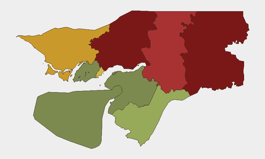
Gabu Region (risk 92) and Oio Region (risk 85) drive the country's composite threat profile, followed by Bafatá (78) and Cacheu (72). These four northern and eastern zones collectively account for the majority of Guinea-Bissau's elevated risk scoring. Risk drivers in these areas are understood to reflect historical patterns of cross-border trafficking, irregular armed-group presence, and limited state capacity rather than acute current incidents. By contrast, southern regions including Bolama (15) and Quinara (38) register substantially lower risk, and the capital sector (Bissau Autonomous Sector, 68) remains in the mid-range, suggesting that geographic remoteness and proximity to maritime borders correlate with elevated scores.
How GeoBit Would Assist
Corporate security teams operating in Guinea-Bissau would benefit from persistent AOI Monitoring & Early Warning focused on the high-risk northern zones (Gabu, Oio, Bafatá, Cacheu) to detect emerging conflict, trafficking, or civil-unrest signals before they escalate. Multi-language OSINT (social media, news, radio) and sentiment & temporal analysis enable continuous scanning of local reporting and unofficial channels for early indicators of instability that may not immediately appear in formal media. Routing & Network Analysis supports duty-of-care planning by identifying secure movement corridors and alternative routes for personnel in or transiting these regions, while satellite & imagery analysis can validate or refute unconfirmed reports of military movement or infrastructure damage.
7-Day Outlook
The near-term trajectory for Guinea-Bissau remains stable, with no indicators of imminent escalation in conflict, civil unrest, or organized crime activity. However, the persistent elevation of risk scores in the northern regions warrants continued monitoring, particularly given historical patterns of cross-border activity and trafficking. Security teams should maintain routine vigilance and update contingency protocols for personnel in Gabu, Oio, Bafatá, and Cacheu regions while capitalizing on the current calm to refresh supply chains, communication plans, and secure-route assessments.
Highest-Risk Areas — Ranked
| # | State / Region | Risk |
|---|---|---|
| 1 | Gabu Region | 92 |
| 2 | Oio Region | 85 |
| 3 | Bafatá Region | 78 |
| 4 | Cacheu Region | 72 |
| 5 | Bissau Autonomous Sector | 68 |
| 6 | Tombali Region | 45 |
| 7 | Quinara Region | 38 |
| 8 | Biombo Region | 32 |
| 9 | Bolama Region | 15 |
Sources
Previous Daily Briefs
A new Guinea-Bissau brief is written every day — each with its own risk map and downloadable CSV. Here's the last week; use the calendar to go further back.
📅 Browse every day by calendar →
Highlighted days have a brief. Tap a day for that day's map & analysis, or “csv” for that day's dataset ($5).
Atlas — our AI intelligence desk — emails them this snapshot personally. Nothing else, no list.