Situation Summary
Iran is experiencing active, large-scale military conflict with the United States as of 11 June 2026, marked by at least three confirmed waves of US strikes on Iranian military installations. The conflict appears to have escalated significantly over the past 48–72 hours, driven by reciprocal military operations and public statements of disapproval between Tehran and Washington. Open-source reporting confirms US Central Command strikes on Iranian facilities, though ground-truth detail on specific locations and damage remains limited due to information control and propaganda saturation in conflict zones.
Key Developments
- Unspecified Iranian military facilities – 11 June 2026
US Central Command confirmed strikes on Iranian military facilities reportedly responsible for recent attacks. Accompanying social-media footage showed nighttime explosions, though exact locations and facility names were not disclosed in available reporting.
- Multiple locations in Iran – 11 June 2026
US officials reported a "third wave" of ongoing US military operations against Iranian targets, indicating sustained and sequential strike campaigns. Specific cities and bases were not identified in open sources.
- Presidential–Military Discord – 11 June 2026
A public statement reflecting tension between Iran's President and military leadership was recorded. Context and substance remain unclear from available English-language reporting.
- Regional Military Activity – 10–11 June 2026
Reports of conventional military force exchanges between the US and Iran, as well as artillery/tank engagements involving the Iranian Air Force, suggest multi-domain conflict activity beyond air strikes alone.
- International Diplomatic Response – 11 June 2026
The international community issued investigation requests and formal disapproval statements regarding US–Iran military actions, signaling diplomatic friction and third-party concern.
- Qatar-US Tactical Engagement – 11 June 2026
Small-arms combat involving Qatari and US forces was reported, suggesting proxy or regional allied involvement in the broader conflict.
Highest-Risk Areas
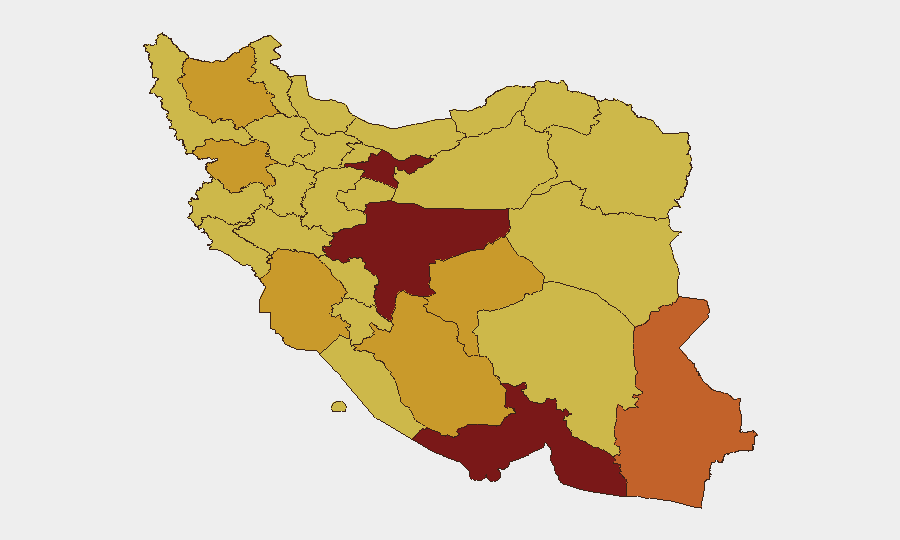
Tehran Province (risk 100) remains the apex threat zone, reflecting its status as the political and administrative capital and likely target set for military and intelligence operations. Isfahan, Hormozgan, and Sistan and Baluchestan provinces (risk 89.3–73.9) follow, driven by military-industrial presence, oil and gas infrastructure, and border/maritime exposure. Provinces along Iran's western and southern borders—Kurdistan, Khuzestan, and Bushehr—are elevated due to proximity to conflict actors and critical national infrastructure. Tehran's composite risk reflects the concentration of government, foreign missions, and commercial activity in the capital; secondary industrial and energy sites in Isfahan and southern provinces amplify regional escalation risk.
How GeoBit Would Assist
Duty-of-care and security teams should activate AOI Monitoring & Early Warning on facilities in Tehran, Isfahan, Hormozgan, and Khuzestan provinces to detect follow-on strikes or military movement in real time. Conflict & Military battle-mapping and Satellite & Imagery Analysis can track damage assessments and force disposition; Intel Sweep and multi-language OSINT (X/Telegram, regional news, government channels) can filter propaganda and corroborate ground truth faster than open social feeds. Routing & Network Analysis supports contingency planning for staff evacuation or supply-chain rerouting away from high-risk corridors.
7-Day Outlook
Escalation appears likely if strike cycles continue unabated; Iranian retaliation rhetoric and military statements suggest potential reciprocal action within days. US and Iranian statements of disapproval and international investigation requests indicate sustained diplomatic friction with low immediate prospect of de-escalation talks. Organizations with personnel or assets in Tehran, Isfahan, and southern provinces should assume heightened military activity, potential collateral-damage risk, and possible disruption to utilities, communications, and transportation for 7–10 days.
Highest-Risk Areas — Ranked
| # | State / Region | Risk |
|---|---|---|
| 1 | Tehran Province | 100 |
| 2 | Isfahan Province | 89.3 |
| 3 | Hormozgan Province | 82 |
| 4 | Sistan and Baluchestan Province | 73.9 |
| 5 | Kurdistan Province | 72.9 |
| 6 | Fars Province | 71.5 |
| 7 | East Azerbaijan Province | 71.3 |
| 8 | Khuzestan Province | 71.1 |
| 9 | Yazd Province | 71.1 |
| 10 | Bushehr Province | 70.6 |
| 11 | Kohgiluye and Buyer Ahmad Province | 70.5 |
| 12 | Kerman Province | 70.2 |
Sources
Previous Daily Briefs
A new Iran brief is written every day — each with its own risk map and downloadable CSV. Here's the last week; use the calendar to go further back.
📅 Browse every day by calendar →
Highlighted days have a brief. Tap a day for that day's map & analysis, or “csv” for that day's dataset ($5).