Situation Summary
Iraq's security environment has deteriorated sharply over the past 24 hours, driven by cross-border Iranian strikes on Kurdish opposition positions and credible militia threats against U.S. diplomatic and energy infrastructure. The U.S. Embassy has issued urgent security alerts warning of potential attacks in Baghdad within 48 hours and flagging planned operations against American-linked oil facilities nationwide. These developments reflect escalating Iran-aligned militia activity and suggest the country is entering a higher-risk operational phase, particularly in Baghdad, northern Iraq, and energy-sector nodes.
Key Developments
- Sulaymaniyah Province (Kurdistan Region) – June 11, 2026: The Islamic Revolutionary Guard Corps announced drone and missile strikes against Iranian Kurdish opposition group positions, with multiple regional sources corroborating attacks on militant bases in the area. This represents direct cross-border Iranian military action and signals willingness to conduct strikes against opposition groups sheltering in Iraq.
- Kirkuk Countryside – June 11, 2026: Airstrikes killed at least three Popular Mobilisation Forces fighters and two Iraqi police officers in the Kirkuk area. Iraqi security sources did not immediately attribute the strikes, creating ambiguity about origin and intent that elevates uncertainty around the tactical environment in this contested northern region.
- Baghdad (Central Districts & Green Zone vicinity) – June 11, 2026: The U.S. Embassy issued an urgent security alert warning U.S. citizens of credible threats from Iran-aligned militia groups targeting central Baghdad within 24–48 hours. The alert recommended immediate evacuation or heightened protective measures, reflecting a significant elevation in assessed threat.
- Iraq-wide Energy Infrastructure – June 11, 2026: A concurrent U.S. Embassy notice warned of planned attacks by Iran and allied militias on U.S.-owned and U.S.-linked oil and energy facilities across Iraq, with particular focus on Basra and northern production zones. This indicates a coordinated threat axis targeting both diplomatic presence and critical commercial assets.
- Social Media Misinformation – June 11, 2026: Resurfacing posts from the March 14, 2026 Green Zone missile and drone attack on the U.S. Embassy have been widely recirculated without clear dating, creating situational awareness noise and misrepresentation of the timeline. This illustrates compounding information-environment risk alongside kinetic threats.
- Multi-Agency Risk Elevation – June 11, 2026: Travel-risk and security intelligence firms updated Iraq advisories across platforms, flagging heightened threat of militia attacks on U.S. diplomatic, military, and commercial targets, particularly in Baghdad, Kirkuk, and Kurdistan. This consensus assessment reinforces the seriousness of current threat reporting.
Highest-Risk Areas
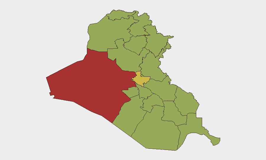
Al-Anbar Governorate (79.1) leads risk rankings, but current threat intensity is concentrated in Baghdad (62.4) and Kirkuk (49.4), reflecting active militia positioning, airstrikes, and explicit targeting intelligence. The Kurdistan Region—particularly Sulaymaniyah and Erbil—faces dual risk from Iranian cross-border operations and PKK/opposition group activity. Energy infrastructure nationwide elevates risk for Basra and northern oil-production regions even where governorate-level composite scores are lower; sectoral concentration of U.S. commercial assets creates a distinct exposure vector independent of general insecurity.
How GeoBit Would Assist
Security teams would deploy AOI Monitoring & Early Warning on Baghdad districts, Kirkuk, and energy facilities to detect militia staging, drone preparation, or attack indicators. OSINT fusion (X/Twitter, regional media, analyst networks) combined with entity extraction and sentiment analysis would disambiguate misinformation from actionable threat updates in real time. Routing & Network Analysis would support contingency evacuation planning and safe-corridor identification for personnel in high-risk zones.
7-Day Outlook
Threat level is expected to remain elevated through mid-June, with highest risk concentrated in the 48-hour window flagged by the U.S. Embassy. If attacks occur, secondary mobilization of militia groups and international response could extend volatility; if the 48-hour window passes without significant incident, threat perception may ease slightly, though underlying militia positioning and Iran-alignment suggest sustained operational intent over the medium term.
Highest-Risk Areas — Ranked
| # | State / Region | Risk |
|---|---|---|
| 1 | Al-Anbar Governorate | 79.1 |
| 2 | Baghdad Governorate | 62.4 |
| 3 | Erbil Governorate | 53.3 |
| 4 | Wasit Governorate | 51.7 |
| 5 | Duhok Governorate | 51.7 |
| 6 | Kirkuk Governorate | 49.4 |
| 7 | Babil Governorate | 49.1 |
| 8 | Al-Qadisiyah Governorate | 49.1 |
| 9 | Dhi Qar Governorate | 49.1 |
| 10 | Al-Muthanna Governorate | 49.1 |
| 11 | Maysan Governorate | 49.1 |
| 12 | Al-Basra Governorate | 49.1 |
Previous Daily Briefs
A new Iraq brief is written every day — each with its own risk map and downloadable CSV. Here's the last week; use the calendar to go further back.
📅 Browse every day by calendar →
Highlighted days have a brief. Tap a day for that day's map & analysis, or “csv” for that day's dataset ($5).