Situation Summary
Israel remains at composite threat level #3 globally (score 100) driven by active regional conflict spanning military operations, diplomatic deterioration, and cross-border tension. Over the past 72 hours, event signals show escalating conventional military exchange with Iran, reduced relations with Syria, Yemen, and Iraq, and Lebanese demands directed at Israel. The South District (risk 100) dominates the risk profile; North District, Tel Aviv, Haifa, Center, and Jerusalem districts all register elevated threat (70–72), indicating geographically distributed vulnerability across population and commercial centers.
Key Developments
- 2026-06-17 · Iran–Israel Military Exchange: Conventional military force reported in both directions (Iran vs. Israel, Israel vs. Iran), with public statements from Tehran. Specific targets and casualty estimates not confirmed in available reporting; operational scope and intent remain under assessment.
- 2026-06-17–18 · Diplomatic Isolation Signals: Israel recorded relation reductions with Syria, Yemen, and Iraq within a 24-hour window, alongside a Lebanese demand (2026-06-17) and Egyptian rejection (2026-06-18). These signal potential coordination among regional actors or unified messaging against Israeli interests.
- 2026-06-15 · Lebanon Threat Escalation: Threat event recorded between Israel and Lebanon; Lebanese party issued formal demand on 2026-06-17. Geographic proximity to North District (risk 72) elevates immediate concern for northern assets.
- 2026-06-16 · Internal Financial/Political Friction: Finance Ministry disapproval of Israel recorded; specifics unavailable. May indicate domestic budget/defense spending dispute or sanctions-related tension.
- 2026-06-18 · Investigative Action by Government: Government body initiated investigation into Israeli entity or individuals; scope, jurisdiction, and target classification pending clarification.
Note: Live web research for the past 24–48 hours returned primarily analytical and diplomatic commentary rather than incident-level data. Tank movements in Gaza City (referenced in Sunday reporting) and southern Lebanon positions are documented but lack precise current timestamps relative to 2026-06-18 03:03 UTC. Further OSINT sweep recommended for granular incident confirmation.
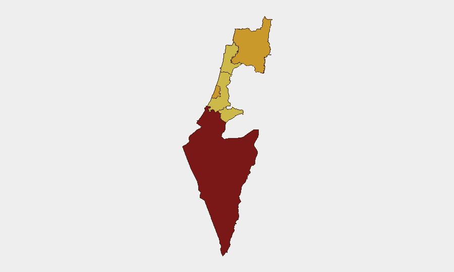
Highest-Risk Areas
South District (100) dominates due to active conventional operations and reported military movements; this remains the primary operational theater. North District (72) is elevated by Lebanon cross-border threats and demands, creating risk to assets within striking range of Hezbollah and related actors. Tel Aviv, Haifa, Center, and Jerusalem districts (70–71.6) reflect distributed vulnerability—Tel Aviv is the commercial/financial hub; Jerusalem is politically sensitive; Haifa and Center host infrastructure and population. The fact that five of six major districts score ≥70 indicates no safe haven within Israel's core territory; threat is national in scope, not localized.
How GeoBit Would Assist
Intel Sweep, OSINT fusion, and multi-language event feeds provide real-time confirmation of military and diplomatic signals, reducing reliance on delayed or secondary sources. AOI Monitoring & Early Warning with persistent watch on South District, North District border zones, and major cities enables duty-of-care teams to detect escalation or incident onset within hours. GIS & Spatial Analysis, satellite & imagery analysis, and battle mapping support asset location verification, corridor risk assessment, and safe-routing alternatives during active operations.
7-Day Outlook
Escalation trajectory is upward: Iran–Israel military exchange, diplomatic isolation of Israel across four regional states, and Lebanon cross-border pressure suggest preparation for sustained confrontation or a negotiation deadline. South and North districts will remain highest-risk; Tel Aviv and Jerusalem are secondary targets of concern. Corporate teams should assume constrained airspace, port delays, and potential internal security investigations; contingency planning and staff relocation protocols merit immediate review.
Highest-Risk Areas — Ranked
| # | State / Region | Risk |
|---|---|---|
| 1 | South District | 100 |
| 2 | North District | 72 |
| 3 | Tel-Aviv District | 71.6 |
| 4 | Haifa District | 70 |
| 5 | Center District | 70 |
| 6 | Jerusalem District | 70 |
Sources
Previous Daily Briefs
A new Israel brief is written every day — each with its own risk map and downloadable CSV. Here's the last week; use the calendar to go further back.
📅 Browse every day by calendar →
Highlighted days have a brief. Tap a day for that day's map & analysis, or “csv” for that day's dataset ($5).