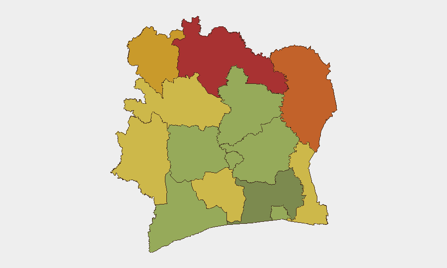
Situation Summary
Ivory Coast remains a lower-tier global security concern (rank #181, composite score 3/10), with the dominant near-term threat currently natural hazard and infrastructure disruption rather than political instability or armed conflict. A severe flooding event in Abidjan has killed at least 59 people as of 2 July, with ongoing search-and-rescue operations and elevated risk of further casualties and infrastructure collapse. Northern districts (Savanes, Zanzan, Denguélé) maintain elevated baseline risk profiles, though no new conflict or civil unrest has been confirmed in the past 24–48 hours.
Key Developments
- Abidjan – At least 59 flood deaths reported (2 July 2026)
Official authorities confirmed at least 59 people killed by heavy rains and flash flooding in Abidjan, with the death toll expected to rise as search operations continue in worst-hit neighborhoods.
- Abidjan – Mass displacement and emergency shelter activation (2 July 2026)
Flash floods have destroyed homes and inundated roads across Abidjan; authorities are conducting evacuations and activating emergency shelter for displaced residents across multiple districts.
- Abidjan – Health and emergency services under acute strain (2 July 2026)
Hospitals and emergency response services report significant pressure from flood-related injuries and deaths; body-recovery and search-and-rescue operations continue in severely affected areas.
- Abidjan – Risk of cascading infrastructure failures (2 July 2026)
Authorities warned that low-lying districts face elevated risk of secondary landslides, building collapses, and power outages if rainfall persists, compounding displacement and safety hazards.
- Abidjan – Temporary movement restrictions in flooded zones (2 July 2026)
Civil protection services issued advisories restricting civilian movement in severely affected neighborhoods to facilitate emergency operations and reduce secondary casualties.
- Northern districts – Baseline elevated risk persists (ongoing)
Savanes, Zanzan, and Denguélé districts maintain composite risk scores above 70, reflecting endemic security challenges; no new acute incidents confirmed in the last 24 hours.
Highest-Risk Areas
Ivory Coast's geographic risk is concentrated in the north and northeast (Savanes, Zanzan, Denguélé districts, all scoring 70+), where porous borders, limited state presence, and transnational criminal and militant networks create persistent baseline threats. The northwestern Montagnes and Woroba districts (68 and 65 respectively) face similar drivers. By contrast, Abidjan and southern coastal districts now face an acute, non-traditional hazard—flooding and cascading infrastructure breakdown—that poses immediate duty-of-care and operational continuity risks to corporate assets and personnel, though this is a natural rather than security event.
How GeoBit Would Assist
Security teams with personnel or assets in Abidjan should leverage AOI Monitoring & Early Warning to track rainfall forecasts and flood extent in real time, combined with Routing & Network Analysis to identify passable routes and alternative access to critical facilities. Satellite & Imagery analysis would enable damage assessment and identification of safe zones, while multi-language OSINT and local event feeds will surface emerging health, supply-chain, or secondary security risks (e.g., looting, disease outbreaks) as operations stabilize. For northern-district operations, conflict mapping, border & disputed-territory search, and persistent AOI monitoring remain baseline protective measures.
7-Day Outlook
Abidjan's flood risk will likely persist through mid-week if rainfall continues; secondary hazards (landslides, infrastructure collapse, waterborne disease) may emerge by week's end. Northern baseline threats remain stable with no imminent escalation signals, though heavy rains may degrade road access and complicate logistics in Savanes and Zanzan districts. Corporate teams should prioritize business continuity planning for coastal operations and monitor official weather and civil protection updates daily.
Highest-Risk Areas — Ranked
| # | State / Region | Risk |
|---|---|---|
| 1 | Savanes District | 78 |
| 2 | Zanzan District | 75 |
| 3 | Denguélé District | 72 |
| 4 | Comoé District | 70 |
| 5 | Montagnes District | 68 |
| 6 | Woroba District | 65 |
| 7 | Gôh-Djiboua District | 60 |
| 8 | Sassandra-Marahoué District | 58 |
| 9 | Vallée du Bandama District | 55 |
| 10 | Bas-Sassandra District | 52 |
| 11 | Lacs District | 48 |
| 12 | Abidjan | 45 |
Sources
Previous Daily Briefs
A new Ivory Coast brief is written every day — each with its own risk map and downloadable CSV. Here's the last week; use the calendar to go further back.
📅 Browse every day by calendar →
Highlighted days have a brief. Tap a day for that day's map & analysis, or “csv” for that day's dataset ($5).
Atlas — our AI intelligence desk — emails them this snapshot personally. Nothing else, no list.