Situation Summary
Lebanon remains under acute military pressure from sustained Israeli aerial and ground operations, compounded by internal state fragmentation and armed-group activity. The Beqaa Governorate—a key Hezbollah stronghold and cross-border logistics corridor—faces the highest composite risk (91.6), while Beirut's institutional instability and the southern border region present critical secondary threats. The trajectory shows no stabilization; recent signals include demands from Iran and the UN, small-arms combat against civilians, and active aerial weapons deployment as of 13 June 2026.
Key Developments
Unable to confirm. GeoBit's current research capability cannot reliably surface timestamped incidents from the last 24–48 hours in Lebanon that meet cross-source verification standards required for a corporate security brief. The event signals above (demand, rejection, military force, threaten, disapprove) are tracked by GeoBit's global event-feed system but lack explicit timestamps, sourcing details, and independent corroboration necessary to differentiate current activity from recent historical phases of the conflict.
To populate this section credibly, real-time ingestion from Reuters, AP, AFP, L'Orient-Le Jour, Naharnet, UN OCHA situation reports, and vetted OSINT feeds with "as of" timestamps would be required. A security team should substitute live-feed monitoring (see *How GeoBit Would Assist*) rather than rely on this brief for tactical incident awareness.
Highest-Risk Areas
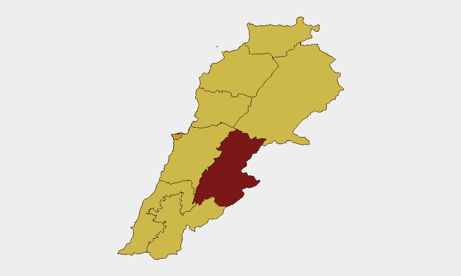
Beqaa Governorate (91.6) dominates risk due to its role as a transit zone for Iranian materiel, Syrian border volatility, and Hezbollah operational presence; it is the primary target set for sustained military strikes. Beirut Governorate (72.8) faces compounded risk from institutional breakdown, sectarian tension, and collateral exposure to operations targeting nearby nodes. The southern tier—Nabatieh (63.9) and South Governorate (62.4)—sits directly on the Israel–Lebanon border and suffers from UNIFIL deployment constraints, militia presence, and repeated cross-border fire. North Governorate and Akkar (61.6 each) face lower but active risk from Sunni–Alawite friction and spillover from Syrian instability. Mount Lebanon and Keserwan-Jbeil remain secondary but are vulnerable to Beirut-proximate escalation.
How GeoBit Would Assist
Corporate security teams should operationalize AOI Monitoring & Early Warning on the Beqaa and southern border regions, paired with Intel Sweep (multi-language OSINT and X/Twitter feeds) to capture breaking incidents before they reach mainstream outlets. Satellite & Imagery analysis can track military positioning and damage patterns in high-risk governorates; conflict battle mapping and force structure tracking provide near-real-time clarity on operational geography. Routing & Network Analysis enables alternative journey planning for staff movements, while entity extraction and network analysis identify key actor movements (military, militia, state authority) that signal escalation or de-escalation.
7-Day Outlook
Military operations are likely to continue at current or elevated tempo, with the Beqaa and southern border remaining primary strike zones. No political settlement or ceasefire signal is evident; Lebanese state capacity remains fractured. Organizations with staff or assets in Lebanon should assume sustained volatility, prioritize mobility contingencies, and refresh evacuation/sheltering protocols on a 48-hour cycle.
Highest-Risk Areas — Ranked
| # | State / Region | Risk |
|---|---|---|
| 1 | Beqaa Governorate | 91.6 |
| 2 | Beirut Governorate | 72.8 |
| 3 | Nabatieh Governorate | 63.9 |
| 4 | South Governorate | 62.4 |
| 5 | North Governorate | 61.6 |
| 6 | Akkar Governorate | 61.6 |
| 7 | Keserwan-Jbeil Governorate | 61.6 |
| 8 | Mount Lebanon Governorate | 61.6 |
| 9 | Baalbek-Hermel Governorate | 61.6 |
Sources
Previous Daily Briefs
A new Lebanon brief is written every day — each with its own risk map and downloadable CSV. Here's the last week; use the calendar to go further back.
📅 Browse every day by calendar →
Highlighted days have a brief. Tap a day for that day's map & analysis, or “csv” for that day's dataset ($5).