Situation Summary
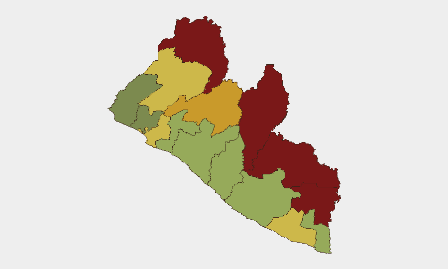
Liberia's national threat environment remains moderate (global rank #92, composite score 11) with no verifiable armed violence or civil unrest in the last 24–48 hours. Current risk drivers are concentrated in drug-trafficking prosecution, port/customs institutional oversight, and political scrutiny of security agencies rather than kinetic incidents. The northeastern border counties (Nimba, Lofa, Grand Gedeh) sustain the highest sub-national risk scores, while Monrovia remains the locus of law-enforcement and judicial activity.
Key Developments
- Monrovia, 11 July — Liberia National Police forwarded defendant Paul King to Monrovia City Court in connection with a major cocaine-trafficking case (reportedly ~US$100 million / 19 million drugs seizure) linked to Roberts International Airport; framed as a national security threat by local media.
- Monrovia, 11 July — Inspector General Col. Coleman issued a public statement declaring that "doors for drug trafficking in Liberia are now closed," signaling sustained law-enforcement operations against narcotics networks and referencing recent major seizures.
- Monrovia (Broad Street), 11 July — Liberia Drugs Enforcement Agency (LDEA) executed an arrest in the central commercial corridor during ongoing street-level narcotics enforcement operations within the last 24–48 hours; specific suspect and quantity details not disclosed in open sources.
- Roberts International Airport / National level, 11 July — Liberia National Police investigation into the "Robertsfield Narcotics Scandal" remains active with continued court forwarding and charges against individuals tied to the cocaine seizure; no new seizures reported but sustained judicial and investigative momentum confirmed.
- National ports, 11 July — Government of Liberia launched a port taskforce targeting illegal mining-related activities, indicating tightened security and regulatory controls at maritime logistics nodes with potential implications for criminal smuggling networks.
- National level, 8–10 July (ongoing) — Political and institutional scrutiny of security and customs operations intensified, including police statements, presidential investigations, and diplomatic engagement (Costa Rica statement); reflects active internal oversight of law-enforcement and border institutions in the context of major drug cases.
Highest-Risk Areas
Nimba County (risk 92) and Lofa County (risk 88) in the northeastern border region drive Liberia's sub-national risk profile, likely reflecting persistent transnational trafficking, limited state presence, and cross-border criminal networks. Grand Gedeh (85) and River Gee (83) sustain similarly elevated scores for analogous reasons. Montserrado County (64), which contains Monrovia and Roberts International Airport, ranks eighth but remains operationally significant as the site of current drug-enforcement activity and national institutions; its lower score reflects greater state institutional capacity. Risk in the interior and coastal counties (below rank 8) remains moderate to low.
How GeoBit Would Assist
Security teams monitoring Liberia should employ Intel Sweep and global event feeds for continuous monitoring of narcotics prosecutions and cross-border trafficking networks; OSINT fusion and corroboration to track political and institutional scrutiny of customs and security agencies; and AOI Monitoring & Early Warning with persistent watches on Roberts International Airport, Monrovia port facilities, and the northern border counties to detect escalation in violence, trafficking volumes, or institutional breakdown. Network & Actor Analysis would map criminal organizations and trafficking corridors, while satellite and imagery analysis could verify port taskforce compliance and smuggling-route activity.
7-Day Outlook
Judicial proceedings against Paul King and related defendants are likely to continue, sustaining media and political attention on drug trafficking and institutional integrity. No imminent escalation to armed conflict or mass civil unrest is indicated; risk remains concentrated in organized-crime prosecution and regulatory enforcement. Monitoring should focus on whether government institutional scrutiny expands into armed-group activity or whether court outcomes trigger political backlash affecting border-region stability.
Highest-Risk Areas — Ranked
| # | State / Region | Risk |
|---|---|---|
| 1 | Nimba County | 92 |
| 2 | Lofa County | 88 |
| 3 | Grand Gedeh County | 85 |
| 4 | River Gee County | 83 |
| 5 | Bong County | 72 |
| 6 | Gbarpolu County | 68 |
| 7 | Grand Kru County | 65 |
| 8 | Montserrado County | 64 |
| 9 | Rivercess County | 58 |
| 10 | Sinoe County | 55 |
| 11 | Margibi County | 52 |
| 12 | Grand Bassa County | 48 |
Sources
Previous Daily Briefs
A new Liberia brief is written every day — each with its own risk map and downloadable CSV. Here's the last week; use the calendar to go further back.
📅 Browse every day by calendar →
Highlighted days have a brief. Tap a day for that day's map & analysis, or “csv” for that day's dataset ($5).
Atlas — our AI intelligence desk — emails them this snapshot personally. Nothing else, no list.