Situation Summary
Lithuania faces elevated but localized security pressure from border-region drone activity, migration/smuggling flows, and infrastructure vulnerability to regional conflict spillover. Over the last 24–48 hours, authorities have managed multiple discrete incidents—illegal border crossings, a human-smuggling arrest, and ongoing airspace alerts—without major breaches or mass casualties. The threat environment remains fragmented rather than systemic, but the convergence of Belarus-linked migration pressure, unmanned-aerial incursions, and proximity to the Ukraine conflict creates compounding operational strain on state security agencies and potential flash-point risks for corporate assets in Vilnius and border counties.
Key Developments
- Vilnius airspace alert (Vilnius County), 3–4 August: Elevated airspace alert and resident sheltering in response to drone activity; alert lifted around 11:00 local time on 4 August after situation stabilized. Defence Ministry cited recent Russian-made and Ukrainian drones entering Lithuanian airspace as trigger for heightened posture.
- Grigiškės body discovery (Vilnius district), morning 4 August: Male body found near cemetery; police and forensic services responding. Cause of death under investigation with no public indication of foul play or wider threat at this stage.
- Šakiai smuggling arrest (Marijampolė County), early 4 August: Border guards detained French national transporting 19 irregular migrants in single vehicle near Lithuania–Poland border corridor; case classified as organized human smuggling and transferred to law enforcement.
- Belarus–Lithuania border crossings (border regions), 24-hour period to 4 August morning: State Border Guard Service prevented 13 attempted illegal crossings from Belarus; incident count consistent with sustained migration pressure but no mass-breach event.
- Defence Ministry airspace initiative (national), announced 3 August: Lithuania announced development of AI-powered air defence and airspace surveillance network integrating radar, camera, mobile sensors, and other feeds; explicitly designed to counter Russian-made and Ukrainian drone incursions and protect critical infrastructure and population centres.
- Lithuanian embassy in Kyiv (Ukraine), within 48 hours prior to 4 August: Two Russian missiles struck near compound, shattering windows, damaging solar panels, scattering debris. No staff injuries. Foreign Ministry condemned strike, plans summons of Russian representative, linked incident to broader regional security escalation.
Highest-Risk Areas
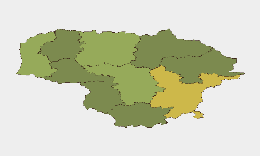
Vilnius County (risk score 68) dominates the national picture, driven by concentration of critical infrastructure, government institutions, international business, and persistent drone-alert activity in surrounding airspace. Kaunas County (58) and Klaipeda County (52) follow, reflecting secondary urban/port infrastructure and proximity to border regions. The elevation of Vilnius County risk reflects both airspace vulnerability to cross-border unmanned systems and the targeting of Lithuanian diplomatic assets abroad, signaling potential secondary targeting of high-profile corporate or institutional nodes in the capital.
How GeoBit Would Assist
Teams with personnel or assets in Lithuania should use AOI Monitoring & Early Warning on Vilnius, Kaunas, and Klaipeda counties to track airspace alerts, border-crossing pressure, and critical-infrastructure incidents in real time. Network & Actor Analysis combined with OSINT fusion (X/Telegram, local media feeds) would enable rapid corroboration of emerging incidents and distinction between localized criminal activity and wider state-linked threats. Routing & Network Analysis supports duty-of-care planning for staff in high-risk counties, particularly during elevated airspace alerts.
7-Day Outlook
Drone-incursion risk and illegal-crossing pressure are likely to persist as long as Belarus-route migration flows and regional conflict dynamics remain elevated. State defence initiatives (AI-surveillance rollout) will incrementally raise incident detection and response tempo. Corporate security teams should anticipate continued airspace alerts in Vilnius and periodic border-region incidents, with low but non-negligible risk of escalation if Ukrainian or Russian drone activity intensifies.
Highest-Risk Areas — Ranked
| # | State / Region | Risk |
|---|---|---|
| 1 | Vilnius County | 68 |
| 2 | Kaunas County | 58 |
| 3 | Klaipeda County | 52 |
| 4 | Siauliai County | 42 |
| 5 | Panevezys County | 38 |
| 6 | Taurage County | 35 |
| 7 | Utena County | 33 |
| 8 | Alytus County | 32 |
| 9 | Telsiai County | 28 |
| 10 | Marijampole County | 25 |
Sources
Previous Daily Briefs
A new Lithuania brief is written every day — each with its own risk map and downloadable CSV. Here's the last week; use the calendar to go further back.
📅 Browse every day by calendar →
Highlighted days have a brief. Tap a day for that day's map & analysis, or “csv” for that day's dataset ($5).
Atlas — our AI intelligence desk — emails them this snapshot personally. Nothing else, no list.