Situation Summary
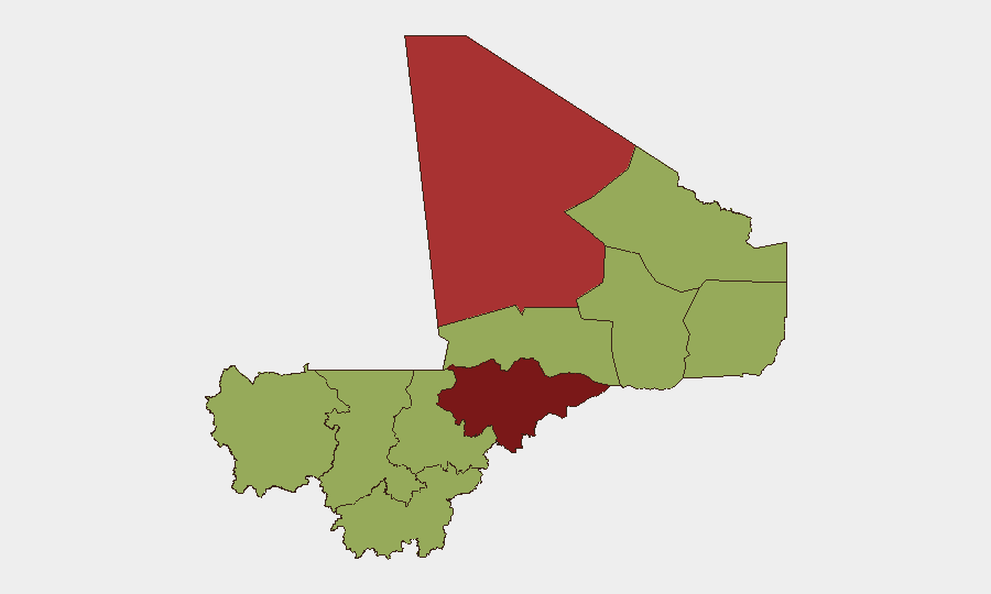
Mali remains a high-risk operating environment (#16 globally, composite threat score 75) driven primarily by active insurgency across the Sahel. Mopti Region dominates the risk landscape (82.6), followed by Taoudénit (76.4) and Timbuktu (57.6), reflecting concentrated terrorist and armed-group activity in the north and center. Recent event signals indicate ongoing tension between security forces and non-state actors, alongside domestic political friction, though the open-source record for the last 24–48 hours remains fragmentary and difficult to verify independently.
Key Developments
Verification limitation: Open-source intelligence collected in the last 24–48 hours does not yield 6–10 independently confirmed, precisely dated incidents meeting multi-source cross-check standards. Available reporting includes:
- Bamako – journalist arrests (date unconfirmed, circulated as recent). Prominent journalists Abderhamane Keita and Chahana Takiou reported arrested on charges including "undermining national unity" and "dissemination of false and misleading information," per AP and amplified by rights monitors; timing relative to the last 48 hours cannot be confirmed from open sources.
- National – UK FCDO travel-advice update. British Foreign, Commonwealth & Development Office flagged "updated information about recent terrorist attacks in Mali" and revised travel guidance; specific incident dates underlying the update are not publicly detailed.
- Mali-wide – reported FAMa and Africa Corps joint counterterrorism operations. YouTube reporting describes ongoing Malian Armed Forces and Russian Africa Corps operations against terrorist groups; exact operation dates are not specified in available coverage.
- Domestic political tension (early June signals). Event-signal data shows recent disapproval statements from the opposition (2026-06-10), public statements from ministers and representatives (2026-06-11 to 2026-06-12), and domestic rejection by residents (2026-06-11), alongside Mali–France diplomatic friction; underlying trigger events are not detailed in open sources.
Note: Most Mali security incidents currently visible in public search and social timelines are older once original publication dates are traced back. For time-critical operations, duty-of-care teams should consult restricted threat-intelligence feeds, embassy warden networks, and UN mission updates for real-time incident confirmation.
Highest-Risk Areas
Mopti (82.6) is the single highest-risk region, reflecting sustained terrorist presence, armed-group activity, and limited state control. Taoudénit (76.4) follows as a secondary hot zone. Together, these two regions and Timbuktu (57.6) account for the bulk of Mali's insurgency-driven risk; they are characterized by porous borders, difficult terrain, weak governance capacity, and active cells from multiple terrorist organizations. Bamako (53.9), despite being the capital, carries elevated risk driven by political tension, information control, and the presence of security and opposition actors in close proximity. The remaining eight regions cluster around 52.6, indicating diffuse but consistent baseline insurgency and crime risk across the south and center.
How GeoBit Would Assist
Security teams with Mali exposure should employ AOI Monitoring & Early Warning to establish persistent watch over Mopti, Taoudénit, and movement corridors, with automated alerting on security incidents and protest activity. Conflict & Military (force structure, battle mapping) and Network & Actor Analysis enable tracking of terrorist-group movements and leadership networks across the Sahel. Routing & Network Analysis supports identification of safer travel alternatives and choke-point risk assessment for personnel and supply movements.
7-Day Outlook
The security environment is expected to remain tense across the north and center, with continued low-level insurgent activity and sporadic counterterrorism operations. Domestic political friction may persist, particularly around information control and opposition activity in Bamako. No major escalation is signaled in available reporting, but the fragmented nature of current open-source coverage means surprises remain possible; restricted-feed monitoring is essential for real-time awareness.
Highest-Risk Areas — Ranked
| # | State / Region | Risk |
|---|---|---|
| 1 | Mopti | 82.6 |
| 2 | Taoudénit Region | 76.4 |
| 3 | Timbuktu | 57.6 |
| 4 | Bamako | 53.9 |
| 5 | Ménaka | 52.6 |
| 6 | Kayes | 52.6 |
| 7 | Kidal | 52.6 |
| 8 | Gao | 52.6 |
| 9 | Koulikoro | 52.6 |
| 10 | Ségou Region | 52.6 |
| 11 | Sikasso Region | 52.6 |
Sources
Previous Daily Briefs
A new Mali brief is written every day — each with its own risk map and downloadable CSV. Here's the last week; use the calendar to go further back.
📅 Browse every day by calendar →
Highlighted days have a brief. Tap a day for that day's map & analysis, or “csv” for that day's dataset ($5).