Situation Summary
Mauritania remains a moderate-risk environment (#66 globally) with six tracked security events and a composite threat score of 17. Current developments center on civil-unrest activity in the capital (Nouakchott) and a significant maritime crisis involving migrant vessels off the Atlantic coast. The country's security profile is dominated by activity in its remote border regions—particularly Tiris Zemmour and the eastern governorates—where terrorist and smuggling networks operate; the capital and coastal zones remain relatively stable but subject to periodic labor and human-rights activism.
Key Developments
- Nouakchott, 22 July 2026 – Women's rights organization IRA staged a sit-in outside Nouakchott-Ouest civil prison demanding release of detained activists and opinion prisoners; the group alleged rights violations against two deputies.
- Nouakchott, 22 July 2026 – Mauritanian gendarmerie dismantled an alcohol import/distribution network and arrested 13 suspects in a joint security operation, indicating organized contraband activity in or near the capital.
- Off Nouakchott coast, 14–18 July 2026 – UNHCR reported three migrant-boat rescue and disembarkation operations resulting in 387 people brought ashore; one vessel from The Gambia carrying approximately 160 persons ran out of fuel and drifted, with 143–144 people reported dead or missing across the incident cluster.
- Nouadhibou port, 14–18 July 2026 – At least one of the maritime disembarkation operations involved the northern port, indicating direct involvement in humanitarian response and potential secondary displacement or overcrowding at reception facilities.
- Separate incident, 14–18 July 2026 – A second migrant boat from Senegal was rescued, with passengers safely brought ashore, suggesting ongoing cross-border maritime movement.
Highest-Risk Areas
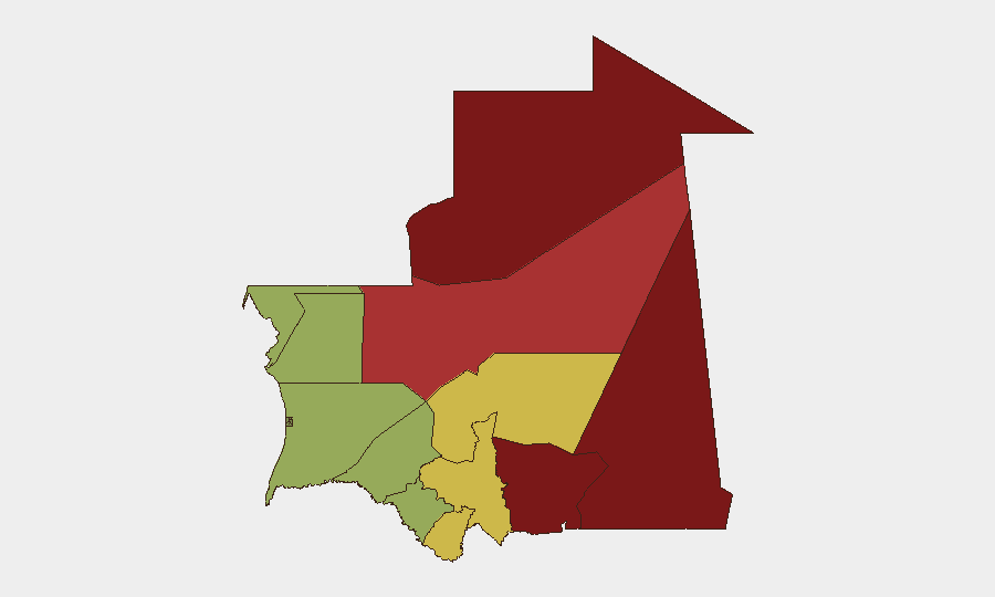
Tiris Zemmour (risk 95) and the two Hodh governorates (Ech Chargui, 85; El Gharbi, 80) constitute the primary threat zone, driven by active terrorist, smuggling, and militant networks operating in sparsely governed border areas with Mali and Algeria. Adrar and Tagant (78 and 68, respectively) present secondary risks rooted in similar cross-border dynamics. In contrast, the capital region and western coastal areas (Trarza, Inchiri, Brakna, Dakhlet Nouadhibou at 55–45) remain lower-risk but experience periodic civil unrest and humanitarian emergencies related to migration and labor disputes.
How GeoBit Would Assist
Security teams operating in Mauritania should employ AOI Monitoring & Early Warning to maintain persistent watch on Tiris Zemmour and the eastern border regions for emerging terrorist or smuggling activity, with real-time alerting configured for personnel locations or asset movements. Intel Sweep (global event feeds, OSINT fusion, multi-language search) provides rapid identification of civil unrest in Nouakchott and maritime incidents affecting ports. Routing & Network Analysis supports alternative journey planning for staff transiting high-risk regions, while Satellite & Imagery Analysis and GIS & Spatial Analysis enable security teams to assess ground conditions and displacement impacts around Nouadhibou and other reception areas during migrant incidents.
7-Day Outlook
Near-term risk remains moderate, with civil activism in Nouakchott likely to persist but remain non-violent. The maritime crisis may generate secondary humanitarian or security pressures in ports and reception facilities, particularly Nouadhibou. No imminent escalation in the border regions is anticipated over the next seven days, though terrorist and smuggling networks continue seasonal operations in remote areas.
Highest-Risk Areas — Ranked
| # | State / Region | Risk |
|---|---|---|
| 1 | Tiris Zemmour | 95 |
| 2 | Hodh Ech Chargui | 85 |
| 3 | Hodh El Gharbi | 80 |
| 4 | Adrar | 78 |
| 5 | Tagant | 68 |
| 6 | Guidimaka | 65 |
| 7 | Assaba | 62 |
| 8 | Gorgol | 58 |
| 9 | Trarza | 55 |
| 10 | Inchiri | 52 |
| 11 | Brakna | 48 |
| 12 | Dakhlet Nouadhibou | 45 |
Sources
Previous Daily Briefs
A new Mauritania brief is written every day — each with its own risk map and downloadable CSV. Here's the last week; use the calendar to go further back.
📅 Browse every day by calendar →
Highlighted days have a brief. Tap a day for that day's map & analysis, or “csv” for that day's dataset ($5).
Atlas — our AI intelligence desk — emails them this snapshot personally. Nothing else, no list.