Situation Summary
Moldova faces sustained but manageable security pressure from Russian military activities along its eastern border and airspace, combined with elevated diplomatic tensions and targeted law-enforcement interdiction of alleged war-support exports. The country remains a transit and logistics corridor affected by the Ukraine conflict without direct large-scale military engagement on its territory. Risk is concentrated in breakaway and border regions; the capital and most populated areas remain operationally stable, though awareness and contingency planning for spillover effects remain warranted.
Key Developments
- Chişinău airspace & eastern border (28–30 July 2026): Moldova's Ministry of Defense reported 15 airspace violations by Russian and Iranian missiles and drones during 2026, with debris confirmed on Moldovan soil in 28 cases and at least 12 incidents involving explosive-bearing ordnance. Incidents concentrated near the Ukraine border.
- Leuşeni border crossing, Hînceşti district (late July, reported 30 July): Increased outbound vehicle traffic and customs delays reported at the Moldova–Romania crossing, prompting official advisory. Likely seasonal/administrative rather than security-driven, but affects transit routing.
- Moldovan citizens transiting to/through Russia (29–30 July advisory update): Ministry of Foreign Affairs updated travel warning citing heightened checks at Russian border points, including extended interrogations, device searches, and reported coercion of men aged 18–60 to sign Russian military service contracts.
- State Weapons Registry digitalization (late July): Ministry of Internal Affairs transferred technical administration of the civilian firearms registry to its Information Technology Service, framed as a cyber-resilience and data-protection measure.
- Russian diplomatic protests (29–30 July): Russian Foreign Ministry lodged formal complaints with Moldova's ambassador regarding alleged incidents involving Russian embassy staff and vehicles, and objected to Moldovan moves to restrict visa-free travel and document mutual recognition with Russia.
- Interdicted military-industrial exports (late July): Moldovan SIS and PCCOCS reported blocking ~21 million lei in exports allegedly destined for the Russian military-industrial complex, characterizing the action as disruption of a "war scheme" and part of compliance-enforcement with sanctions/non-support policies.
Highest-Risk Areas
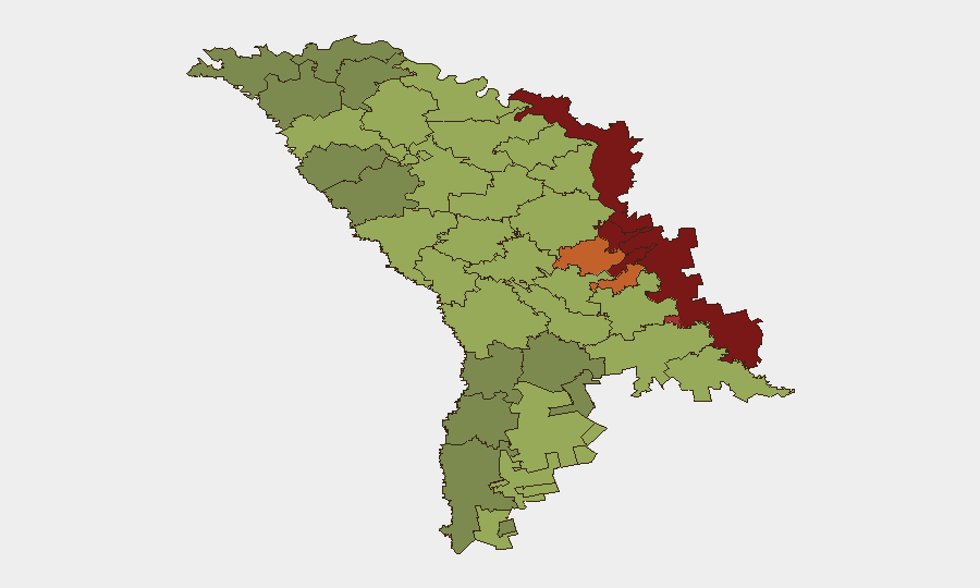
The Left Bank of the Dniester (ATU, risk 85), Dubăsari (82), and Bender (79) drive Moldova's overall risk profile and reflect the frozen-conflict zone and breakaway territories where state authority is contested, Russian military presence is entrenched, and governance and law-enforcement capacity are severely constrained. Secondary risk clusters in Criuleni, Rezina, and Taraclia (75, 58, 55 respectively) reflect border-proximity and cross-border smuggling/trafficking routes. Chişinău itself ranks 12th at risk 49—manageable for business and diplomatic operations—but security teams should factor in spillover from border incidents and heightened diplomatic friction.
How GeoBit Would Assist
Persistent area-of-interest monitoring and early warning over the Dniester corridor, airspace entry points, and key border crossings (Leuşeni, others) would enable real-time alerting on drone/missile activity, customs delays, or military repositioning. Conflict and military intelligence (force structure, weapons tracking, battle-mapping) combined with OSINT fusion (X/Telegram feeds, ministry statements, radio SIGINT) would provide corroborated early signals of escalation or deliberate targeting. Routing and network analysis tools assist security teams in planning resilient travel and supply-chain alternatives when specific crossing points or corridors become congested or unsafe.
7-Day Outlook
Airspace violations and drone debris are likely to persist at current baseline given the active conflict in Ukraine; diplomatic tension with Russia over sanctions enforcement and visa restrictions is unlikely to de-escalate in the near term. No substantiated indicators of imminent large-scale military action, major protests, or infrastructure attacks are evident, but border and airspace vigilance should remain heightened.
Highest-Risk Areas — Ranked
| # | State / Region | Risk |
|---|---|---|
| 1 | Administrative-Territorial Units of the Left Bank of the Dniester | 85 |
| 2 | Dubăsari | 82 |
| 3 | Bender | 79 |
| 4 | Criuleni | 75 |
| 5 | Rezina | 58 |
| 6 | Taraclia | 55 |
| 7 | Gagauzia | 54 |
| 8 | Căușeni | 53 |
| 9 | Soroca | 52 |
| 10 | Ștefan Vodă | 51 |
| 11 | Orhei | 50 |
| 12 | Chișinău | 49 |
Sources
Previous Daily Briefs
A new Moldova brief is written every day — each with its own risk map and downloadable CSV. Here's the last week; use the calendar to go further back.
📅 Browse every day by calendar →
Highlighted days have a brief. Tap a day for that day's map & analysis, or “csv” for that day's dataset ($5).
Atlas — our AI intelligence desk — emails them this snapshot personally. Nothing else, no list.