Situation Summary
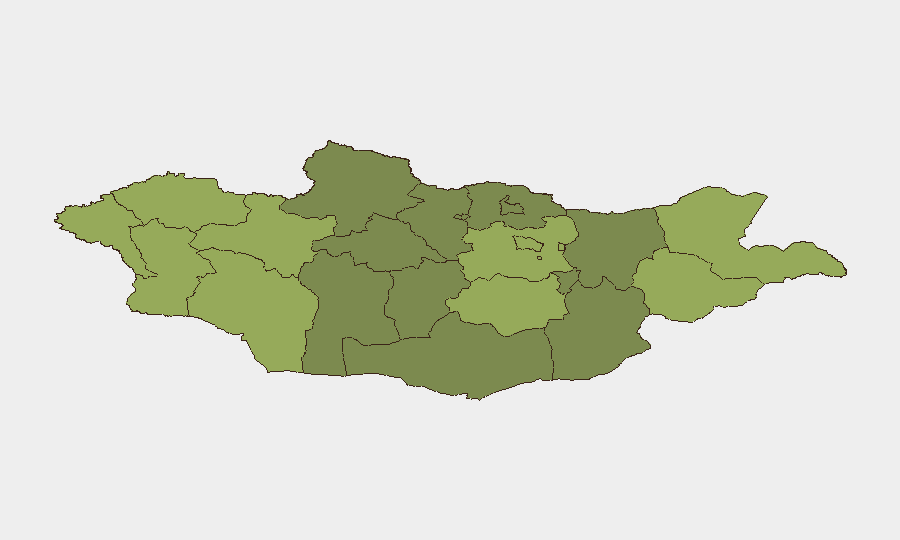
Mongolia's overall security environment remains stable, with a composite threat score of 21 and no reports of large-scale political violence, organized conflict, or civil unrest in the past 24–48 hours. The primary operational risks facing corporate personnel and assets are environmental (active flood warnings across multiple river systems) and health-related (bubonic plague alerts affecting 17 of 21 provinces), rather than security or conflict-driven. Eastern border provinces—Dornod and Sükhbaatar—register the highest composite risk scores and warrant elevated monitoring, though specific triggering incidents have not been confirmed in the current reporting window.
Key Developments
- Rural Mongolia (location unspecified), mid-July 2026 – Israeli tourists were attacked at a campsite; one victim sustained a fractured jaw. The group was assisted by the Israeli embassy and departed the country. *Risk implication:* Isolated but serious crime against foreign nationals at remote sites; reflects vulnerability of travelers outside urban centers.
- Nationwide, ongoing through 17 July – Mongolia's meteorology and emergency agencies issued active flood warnings for multiple river systems, with water levels above danger thresholds and further rises expected. Residents were advised to avoid riverbanks. *Risk implication:* Affects road accessibility, bridge stability, and rural emergency-response capacity; overland travel planning requires current local advisories.
- Nationwide, active summer 2026 – Mongolia's National Center for Zoonotic Diseases maintains a bubonic plague alert for 17 of 21 provinces, linked to rural travel and illegal marmot hunting. *Risk implication:* Elevated disease risk for personnel with rural exposure; may trigger localized health screenings or movement restrictions.
- Ulaanbaatar and major project sites, current progress report – COP17 conference facility construction is approximately 90% complete, with crews working extended hours through the Naadam holiday period. *Risk implication:* Heavy construction activity and temporary traffic disruptions near venue areas; occupational safety risks on-site.
- Fuel stations nationwide, effective 15 July 2026 – AI-92 gasoline prices increased by 250 MNT per liter following regulatory approval. *Risk implication:* Higher transport costs for domestic operations; no protest activity currently reported.
Highest-Risk Areas
Dornod and Sükhbaatar provinces in eastern Mongolia carry the highest composite risk scores (58 and 55 respectively), likely driven by proximity to sensitive borders, remote infrastructure, and limited emergency-response capacity. Uvs, Khovd, and Bayan-Ölgii (western provinces) also rank elevated, reflecting geographical isolation and limited service availability. Ulaanbaatar, despite its larger population and economic activity, ranks seventh at 45—below several rural provinces—suggesting that risk in the capital is more concentrated in specific districts or tied to transient factors such as construction activity and seasonal tourism influxes.
How GeoBit Would Assist
Security teams should deploy persistent AOI (Area-of-Interest) Monitoring & Early Warning on Dornod and Sükhbaatar provinces to capture emerging incidents in real time. Intel Sweep and multi-language OSINT (social feeds, local media, radio SIGINT) can track flood conditions, health alerts, and localized crime patterns affecting corporate locations. Routing & Network Analysis supports alternative journey planning for personnel traveling between provinces, accounting for current flood and road-closure conditions. Regular Environmental & Health monitoring during summer months provides early notice of disease or weather escalation requiring duty-of-care response.
7-Day Outlook
Flood warnings are expected to remain active through mid-to-late July as river levels crest; personnel should avoid riverbank areas and schedule critical travel during lower-risk windows. Bubonic plague alerts will likely persist through the summer season, reinforcing the need for health protocols in rural operations. No major security or political developments are anticipated in the near term, though remote-site safety protocols should remain enhanced given the recent campsite incident.
Highest-Risk Areas — Ranked
| # | State / Region | Risk |
|---|---|---|
| 1 | Dornod | 58 |
| 2 | Sükhbaatar | 55 |
| 3 | Uvs | 52 |
| 4 | Khovd | 50 |
| 5 | Bayan-Ölgii | 48 |
| 6 | Govi-Altai | 46 |
| 7 | Ulaanbaatar | 45 |
| 8 | Zavkhan | 44 |
| 9 | Töv | 42 |
| 10 | Dundgovi | 40 |
| 11 | Darkhan-Uul | 38 |
| 12 | Ömnögovi | 37 |
Sources
Previous Daily Briefs
A new Mongolia brief is written every day — each with its own risk map and downloadable CSV. Here's the last week; use the calendar to go further back.
📅 Browse every day by calendar →
Highlighted days have a brief. Tap a day for that day's map & analysis, or “csv” for that day's dataset ($5).
Atlas — our AI intelligence desk — emails them this snapshot personally. Nothing else, no list.