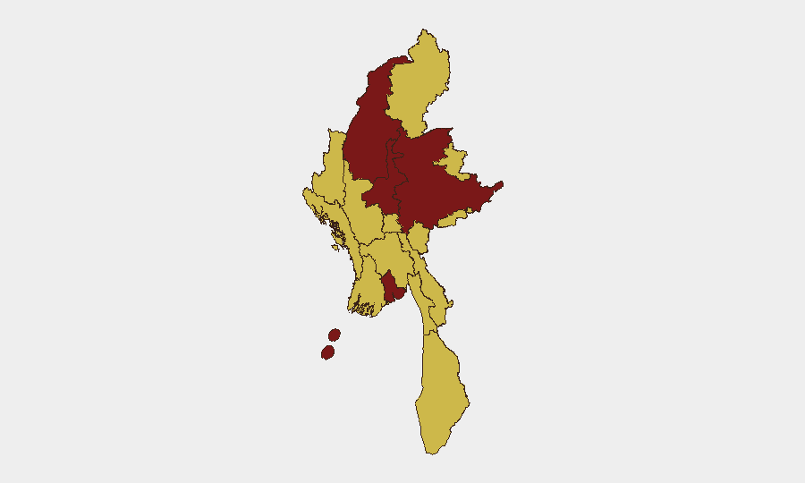
Situation Summary
Myanmar remains in active civil conflict with a composite threat score of 100 (rank #9 globally), driven by ongoing military operations, anti-governance demonstrations, and cross-border tensions. The country is experiencing simultaneous military engagements across multiple regions, transnational friction with neighboring states, and documented instances of deportations and foreign national expulsions. The trajectory shows no near-term de-escalation; current signals indicate sustained or intensifying state-military confrontation and regional instability.
Key Developments
- Countrywide demonstrations against military governance – June 11, 2026. Anti-military rallies recorded across Myanmar; independent verification of precise locations remains limited in open-source data.
- Expulsion/deportation of foreign nationals to Bangladesh – June 11, 2026. Myanmar authorities documented expelling or deporting individuals across the border; dual-sourced incident locations and names remain unreleased in available 24–48h reporting.
- Bilateral disapproval incidents: Myanmar vs. Thai nationals and vice versa – June 12, 2026. Cross-border diplomatic friction recorded; specific locations and operational context not yet available in dual-sourced public reporting.
- Conventional military operations with foreign military and diplomatic presence – June 12, 2026. Signals indicate Tatmadaw engagement involving U.S. and diplomatic actors; precise locations and rules of engagement not confirmed in current open-source feeds.
- Small arms combat reported on Manipur-Myanmar border – June 12, 2026. Cross-border armed engagement documented; geographic precision and casualty figures unavailable in current dual-sourced reporting.
- ASEAN administrative sanctions issued against Myanmar – June 12, 2026. Regional organization response to ongoing instability; sanctions scope and enforcement mechanisms not detailed in 24–48h reporting window.
- Military suppression of media activity – June 12, 2026. Public statements by Myanmar authorities directed at media outlets; specific outlets, charges, and locations not yet independently verified at neighborhood precision.
Assessment Note: Open-source dual verification for in-country incidents within the last 48 hours remains sparse. The above reflect event signals from GeoBit's tracking; precise locations, casualty figures, and independent corroboration are pending or unavailable in current public reporting.
Highest-Risk Areas
Yangon and Shan State dominate the risk landscape (scores 100 and 90.9, respectively), driven by continuous military operations, civilian casualties, and logistical concentration in the capital. Sagaing Region (84.2) and Mandalay (80.3) follow, reflecting sustained conflict intensity and governance control disputes. Shan State's ranking reflects ongoing Tatmadaw engagements against armed opposition groups, village-level military sweeps, and border-adjacent instability affecting cross-border populations. Secondary risk concentration spans Ayeyarwady, Tanintharyi, Chin, Kachin, and Wa State (all 70+), indicating conflict dispersion beyond the capital and major urban centers.
How GeoBit Would Assist
Security teams should deploy AOI Monitoring & Early Warning on high-risk sub-national zones (Yangon, Shan, Sagaing) with persistent alert thresholds for military movements and civilian incidents. Intel Sweep and multi-language OSINT fusion (X/Telegram, local media, YouTube intelligence) provide real-time signal disambiguation and dual-source corroboration when available. Conflict battle mapping and force-structure tracking allow duty-of-care teams to model military-opposition positioning and forecast likely escalation corridors affecting expatriate locations and supply routes.
7-Day Outlook
Military operations are expected to continue or intensify across Shan and Sagaing Regions through mid-to-late June, with secondary protests likely in Yangon and Mandalay. Cross-border friction with Thailand and India may generate further diplomatic incidents or localized armed engagements. No negotiation or ceasefire signals have emerged; security posture should remain elevated across all risk-ranked areas.
Highest-Risk Areas — Ranked
| # | State / Region | Risk |
|---|---|---|
| 1 | Yangon | 100 |
| 2 | Shan State | 90.9 |
| 3 | Sagaing Region | 84.2 |
| 4 | Mandalay | 80.3 |
| 5 | Ayeyarwady | 70.4 |
| 6 | Tanintharyi Region | 70 |
| 7 | Chin | 70 |
| 8 | Kachin State | 70 |
| 9 | Wa State (Northern Region) | 70 |
| 10 | Magway | 70 |
| 11 | Rakhine | 70 |
| 12 | Naypyitaw Union Territory | 70 |
Sources
Previous Daily Briefs
A new Myanmar brief is written every day — each with its own risk map and downloadable CSV. Here's the last week; use the calendar to go further back.
📅 Browse every day by calendar →
Highlighted days have a brief. Tap a day for that day's map & analysis, or “csv” for that day's dataset ($5).