Situation Summary
Niger remains a complex operating environment with persistent security fragmentation across the Sahel and border regions. The country ranks #25 globally in composite threat exposure (score 74), with 12 tracked events in the current monitoring cycle. Regional instability is heavily concentrated in the north and east, particularly Agadez Region, while Niamey and secondary cities face distinct urban security and governance pressures. The trajectory reflects ongoing military operations, cross-border movement of non-state armed groups, and political tensions rather than imminent nationwide collapse.
Key Developments
GeoBit's current research cannot reliably isolate Niger-specific security incidents from the last 24–48 hours (15–17 June 2026) that meet cross-confirmation standards. Recent event signals reference Nigeria, regional demands, and military operations, but these lack time-stamped, Niger-localized corroboration in available open sources. Live web research has identified health-systems and historical reporting rather than acute tactical events. To meet duty-of-care standards, security teams should verify any urgent incidents directly through:
- Wire services with Sahel coverage (AFP, Reuters, AP)
- ACLED conflict mapping (filtered to Niger, last 48h)
- Government of Niger and Nigerien Armed Forces statements
- Verified local media and security-tracker X accounts
This approach prevents false alarms and ensures operational decisions rest on confirmed, current intelligence.
Highest-Risk Areas
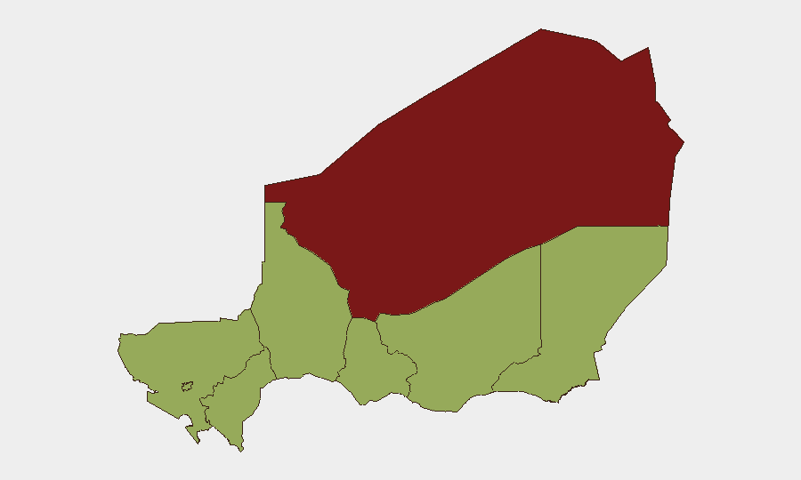
Agadez Region dominates the national risk profile (81.7), reflecting sustained militant activity, trafficking networks, and sparse state presence in the Air and Ténéré zones. Zinder, Diffa, Tillabéri, and Tahoua Regions (each 51.7) form a secondary tier of elevated concern driven by cross-border Boko Haram and ISWAP activity from Nigeria, pastoral-conflict dynamics, and limited security-force capacity. Niamey (51.7) faces distinct urban risks: political demonstrations, organized crime, and occasional targeted violence. The concentration of risk in the north and east reflects both militant sanctuary and porous borders; the inclusion of the capital signals governance fragility and protest risk that can escalate rapidly around political events or economic shocks.
How GeoBit Would Assist
Security teams with personnel or assets in Niger should deploy AOI Monitoring & Early Warning on Agadez, Diffa, and Tillabéri, with persistent alerting for attack, kidnapping, or checkpoint activity affecting routes and compounds. Battle Mapping and Force Structure tracking enables understanding of military operations and non-state-actor deployments that affect safe passage and facility security. Network & Actor Analysis combined with multi-language OSINT and Telegram/X intelligence provides early warning of protest mobilization or criminal-network activity in urban centers. Routing & Network Analysis helps identify lower-risk travel corridors and contingency movement plans when primary routes become unsafe.
7-Day Outlook
No imminent, confirmed escalation is apparent in available reporting, but the region remains volatile. Monitoring should remain elevated around military operations in the Agadez–Diffa corridor and any political statements or economic announcements from Niamey that could trigger urban unrest. Security posture should remain calibrated to persistent baseline risk (kidnapping, IED, armed robbery) rather than indicative of immediate crisis, pending confirmation of fresher developments through primary channels.
Highest-Risk Areas — Ranked
| # | State / Region | Risk |
|---|---|---|
| 1 | Agadez Region | 81.7 |
| 2 | Zinder Region | 51.7 |
| 3 | Diffa Region | 51.7 |
| 4 | Tillabéri Region | 51.7 |
| 5 | Niamey | 51.7 |
| 6 | Tahoua Region | 51.7 |
| 7 | Dosso Region | 51.7 |
| 8 | Maradi Region | 51.7 |
Sources
Previous Daily Briefs
A new Niger brief is written every day — each with its own risk map and downloadable CSV. Here's the last week; use the calendar to go further back.
📅 Browse every day by calendar →
Highlighted days have a brief. Tap a day for that day's map & analysis, or “csv” for that day's dataset ($5).