Situation Summary
Nigeria remains Africa's highest-ranked terrorism and insurgency driver, with composite threat score 100 and 579 tracked events. The security landscape is characterized by persistent armed group activity in the northwest and northeast, compounded by inter-communal tensions, banditry, and emerging operational security breaches at critical government facilities. Government stabilization efforts—agricultural mechanization, infrastructure projects, and transport safety upgrades—are underway in high-risk zones, but security incidents continue to outpace containment capacity.
Key Developments
- NIPSS Kuru, Plateau State (16 June, evening): Armed gunmen breached the National Institute for Policy and Strategic Studies compound, killing at least one security officer before forces regained control. Management confirmed staff and participants were secured and formal investigation opened.
- NIPSS Kuru perimeter (16 June, early morning): A separate security incident was reported near the NIPSS campus earlier the same day; security forces responded and the facility remained operational.
- Sokoto State (16 June): Federal–state initiative distributed 55 tractors to farmers in Gada and Goronyo LGAs in response to food-security pressures in insecurity-affected rural areas.
- Kaduna State, Igabi LGA (16 June): Governor announced ₦34 billion erosion-control and environmental remediation project affecting ~900 residents in Rigasa and neighboring communities, with ₦2.4 billion compensation allocated.
- Jigawa State (16 June): Government delivered flood-prevention and emergency-response equipment to 15 riverine communities ahead of anticipated 2026 rainy-season flooding.
- Zamfara State, Gusau (16 June): Automotive training and CNG conversion centre inaugurated; 100 youths and technicians graduated in safe-transport maintenance skills.
- Kano State (16 June): Federal government donated CNG-powered buses to three universities as part of Democracy Day activities and campus safety infrastructure improvements.
Highest-Risk Areas
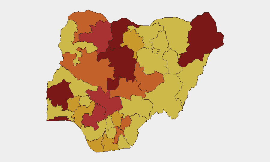
Katsina State (risk 100) and Oyo State (risk 97) rank highest on GeoBit's sub-national index, driven primarily by active banditry, kidnapping, and insurgent recruitment in the northwest corridor. Borno (93.4), Kaduna (91.9), and the Federal Capital Territory (89.7) follow, reflecting sustained Boko Haram/ISWAP activity in the northeast and persistent kidnapping and armed robbery in north-central zones. Katsina's position as top-ranked reflects its use as a transit and operational zone for cross-border bandit networks; Oyo's elevation reflects recent surge in kidnapping-for-ransom along key transport corridors in the southwest. Together, these five states account for the majority of high-consequence security events in Nigeria.
How GeoBit Would Assist
Security teams with personnel or assets in Nigeria should employ AOI Monitoring & Early Warning on Katsina, Kaduna, and Borno to detect emerging attack patterns and movement of armed groups in near-real time. Intel Sweep and OSINT fusion (X/Twitter, Telegram, YouTube, multi-language search) track emerging demands, hostage situations, and public statements by insurgent actors—as flagged in the 15–17 June event signals—enabling duty-of-care teams to anticipate operational shifts. Routing & Network Analysis and GIS & Spatial Analysis support alternative journey planning and asset-location risk assessment in high-threat corridors (Katsina–Kaduna–FCT axis).
7-Day Outlook
Near-term trajectory remains volatile. The NIPSS breach signals potential targeting of government infrastructure and high-profile facilities; copycat incidents or sustained operational pressure on similar sites cannot be ruled out in the next 7 days. Government agricultural, infrastructure, and transport initiatives may reduce localized grievance-driven recruitment pressure, but will not arrest active insurgent or bandit operations. Rainy-season onset across Jigawa and adjacent zones may impede both security-force mobility and armed-group logistics, creating a temporary tactical equilibrium.
Highest-Risk Areas — Ranked
| # | State / Region | Risk |
|---|---|---|
| 1 | Katsina State | 100 |
| 2 | Oyo State | 97 |
| 3 | Borno State | 93.4 |
| 4 | Kaduna State | 91.9 |
| 5 | Federal Capital Territory | 89.7 |
| 6 | Lagos State | 88.9 |
| 7 | Zamfara State | 78.9 |
| 8 | Kogi State | 78.2 |
| 9 | Edo State | 76 |
| 10 | Sokoto State | 75.8 |
| 11 | Niger State | 75.5 |
| 12 | Nasarawa State | 75.1 |
Sources
Previous Daily Briefs
A new Nigeria brief is written every day — each with its own risk map and downloadable CSV. Here's the last week; use the calendar to go further back.
📅 Browse every day by calendar →
Highlighted days have a brief. Tap a day for that day's map & analysis, or “csv” for that day's dataset ($5).