Situation Summary
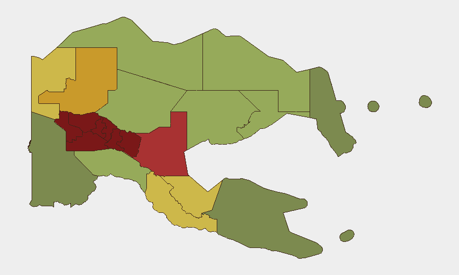
Papua New Guinea remains a persistently high-risk operating environment with a composite threat score of 3, driven primarily by localized tribal conflict, criminal activity, and weak state capacity in the highlands. The country's security posture has not materially shifted in the last 48 hours, though underlying tensions in the Southern Highlands, Enga, and Hela provinces remain elevated and cyclical. No discrete security incidents have been verified in open sources for 23–24 June 2026. Organizations with personnel or assets in PNG should maintain standard duty-of-care protocols and area-specific situational awareness.
Key Developments
No verified security incidents have been identified in Papua New Guinea during the 24–48 hour window of 23–24 June 2026. Open-source reporting, social media, and regional news feeds have not surfaced discrete events meeting corroboration thresholds (two independent, contemporaneous sources). Corporate security teams should note that absence of reported incidents does not indicate absence of risk—particularly in remote and underreported highland provinces where communications infrastructure is limited and local media coverage is sparse. Continued monitoring via dedicated intelligence feeds, local media liaison, and ground intelligence remains essential.
Highest-Risk Areas
The Southern Highlands (risk 98), Enga (96), and Hela (94) provinces form the acute threat core, driven by endemic tribal-boundary disputes, resource competition, and limited government presence. The broader highlands corridor—encompassing Eastern Highlands (92), Western Highlands (90), and Jiwaka (88)—exhibits structurally similar vulnerabilities: dispersed populations, clan-based governance, weak police capacity, and cycles of retaliatory violence. The National Capital District (Port Moresby, risk 85) remains significant for criminal targeting of expatriates and business assets, though organized state response is comparatively stronger than in provincial areas. Risk outside the top six provinces declines measurably but remains above global baseline.
How GeoBit Would Assist
Security teams managing PNG exposure should employ AOI (Area-of-Interest) Monitoring & Early Warning on the Southern Highlands, Enga, and Hela to detect conflict escalation, roadblock activity, or displacement signals before they reach mainstream media. Multi-language OSINT and X/Twitter intelligence targeting local PNG police, provincial authorities, and community networks provide real-time granularity unavailable through international news cycles. Routing & Network Analysis supports duty-of-care teams in pre-positioning alternative travel routes and safe havens in high-risk provinces, while GIS & Spatial Analysis allows overlay of incident clusters against corporate asset and personnel locations to identify specific exposure concentrations.
7-Day Outlook
No near-term escalation is forecast for the next 7 days based on available intelligence. Seasonal and cyclical patterns suggest the highlands remain susceptible to localized flare-ups, particularly where land disputes or resource access intersect with clan politics, but no specific trigger events have been identified. Organizations should assume baseline highlands risk will persist and ensure continuity of local intelligence collection and staff safety briefings.
Highest-Risk Areas — Ranked
| # | State / Region | Risk |
|---|---|---|
| 1 | Southern Highlands | 98 |
| 2 | Enga | 96 |
| 3 | Hela | 94 |
| 4 | Eastern Highlands | 92 |
| 5 | Western Highlands | 90 |
| 6 | Jiwaka | 88 |
| 7 | National Capital District | 85 |
| 8 | Simbu | 82 |
| 9 | Morobe | 78 |
| 10 | East Sepik | 72 |
| 11 | Sandaun | 68 |
| 12 | Oro | 66 |
Sources
Previous Daily Briefs
A new Papua New Guinea brief is written every day — each with its own risk map and downloadable CSV. Here's the last week; use the calendar to go further back.
📅 Browse every day by calendar →
Highlighted days have a brief. Tap a day for that day's map & analysis, or “csv” for that day's dataset ($5).