Situation Summary
Saint Lucia remains at composite threat level 14 (global rank #85) with no verified security incidents reported in the last 24–48 hours (July 18–19, 2026). The security environment is characterized by persistent street crime—armed robbery, assault, burglary, and occasional homicide—concentrated in urban centers, particularly Castries. The U.S. State Department's Level 2 travel advisory (updated July 10, 2026) reflects this baseline risk profile; no acute escalation or new incident clusters have emerged in the current reporting window.
Key Developments
No verified incidents with specific location, date, and event confirmation have been identified in Saint Lucia for July 18–19, 2026 from open-source channels or recent social-media reporting. Current web chatter primarily references the July 10 U.S. travel advisory update and reiterated crime-pattern warnings rather than documenting fresh, time-stamped events.
*For situational context (pre-July 18):* Royal Saint Lucia Police Force aggregate crime statistics for January 1–July 10, 2026 showed declines in several major categories compared to 2025, and recovery of 39 illegal firearms; however, these are cumulative figures and predate the current reporting window.
Highest-Risk Areas
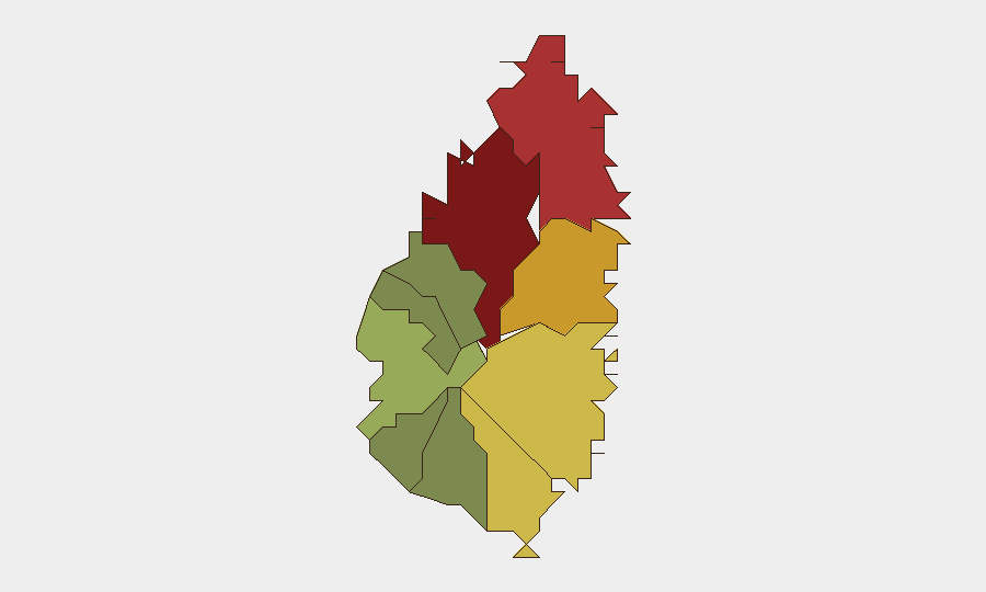
Castries (risk score 95) and Gros Islet (78) drive the island's threat profile, accounting for the majority of armed robbery, assault, and property crime. Dennery (72), Vieux Fort (68), and Micoud (65) form a secondary tier of elevated urban and peri-urban risk. These concentrations reflect gang activity, drug-market competition, and economic inequality; tourist resorts and nightlife venues in these zones—particularly in Castries and Gros Islet—remain frequent incident sites. Canaries, Laborie, Choiseul, and Anse La Raye present substantially lower risk (scores 12–38).
How GeoBit Would Assist
Corporate security and duty-of-care teams operating in Saint Lucia should employ Intel Sweep and global event feeds for real-time detection of new crime incidents, civil unrest, or infrastructure disruption; OSINT fusion (X/Twitter, local news, and multi-language search) to corroborate emerging threats and separate noise from actionable intelligence; and AOI Monitoring & Early Warning with persistent watch on Castries, Gros Islet, and other designated high-risk areas to alert teams to clusters of violence, road closures, or protest activity. GIS & Spatial Analysis and Routing & Network Analysis support duty-of-care planning—identifying safer transit corridors, alternative meeting locations, and real-time adjustment of travel itineraries in response to localized incident data.
7-Day Outlook
No near-term escalation is anticipated. Crime patterns are expected to remain endemic to identified high-risk zones, with seasonal variation driven by tourist influx and local economic conditions. Teams should maintain baseline awareness protocols and monitor for any cluster of incidents in Castries or Gros Islet that might signal a tactical shift in gang activity or organized crime.
Next Update: 2026-07-20 (or as new verified incidents emerge).
Highest-Risk Areas — Ranked
| # | State / Region | Risk |
|---|---|---|
| 1 | Castries | 95 |
| 2 | Gros Islet | 78 |
| 3 | Dennery | 72 |
| 4 | Vieux Fort | 68 |
| 5 | Micoud | 65 |
| 6 | Soufrière | 42 |
| 7 | Laborie | 38 |
| 8 | Choiseul | 35 |
| 9 | Anse La Raye | 28 |
| 10 | Canaries | 12 |
Sources
Previous Daily Briefs
A new Saint Lucia brief is written every day — each with its own risk map and downloadable CSV. Here's the last week; use the calendar to go further back.
📅 Browse every day by calendar →
Highlighted days have a brief. Tap a day for that day's map & analysis, or “csv” for that day's dataset ($5).
Atlas — our AI intelligence desk — emails them this snapshot personally. Nothing else, no list.