Situation Summary
Samoa remains a low-threat environment with no acute security, civil-order, or crime incidents verified in the last 24–48 hours. The country ranks #178 globally on GeoBit's composite threat score and continues to experience stable operating conditions for corporate and expatriate personnel. The primary active risk drivers are structural—ongoing dengue outbreak pressures on healthcare and El Niño-linked climate stress—rather than discrete security events. No deterioration in the near-term threat posture is anticipated.
Key Developments
No discrete security, conflict, crime, civil-unrest, or infrastructure incidents have been verified in Samoa within the last 24–48 hours (since 13 July 2026) that meet corporate security reporting thresholds.
Background context (not current incidents):
- Dengue outbreak (declared, ongoing through July 2026) – Health services under strain; routine precaution for personnel in Tuamasaga and high-movement areas.
- El Niño onset (declared, ongoing) – Water availability, hydropower supply, and wildfire risk elevated; agricultural productivity forecast to decline.
- China Pacific missile test (6 July, >8 days ago) – Strategic/diplomatic issue; no operational security impact on corporate assets or personnel movement.
- Political proceedings (Apia, 9 July, >5 days ago) – FAST Party involvement in HRPP governance challenge; routine political activity, no public-order impact reported.
Highest-Risk Areas
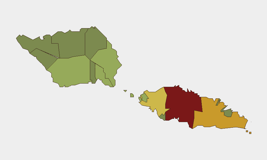
Tuamasaga (risk 85) dominates the sub-national profile, reflecting Apia's role as the capital and primary commercial hub; concentrated population, port activity, and infrastructure dependency drive exposure to health, climate, and logistical disruption. Ātua (71) and Aʻana (62) follow as secondary concern zones, with lower-risk districts (Vaisigano, Vaʻa-o-Fonoti) presenting minimal discrete threat. The risk gradient reflects population density and service concentration rather than active conflict or crime hotspots. Personnel and supply-chain assets in Tuamasaga warrant routine dengue and climate-resilience protocols; other districts present baseline country risk only.
How GeoBit Would Assist
AOI Monitoring & Early Warning would maintain persistent watch on Tuamasaga and Ātua with alerting for any emergence of protest, public-order, health-system breakdown, or port/infrastructure disruption. Environmental & Health intelligence (dengue case tracking, El Niño impact modeling, water/power forecasting) would inform HR, supply-chain, and duty-of-care planning. OSINT fusion (news, social media, radio SIGINT, multi-language search) would provide 24-hour coverage of political developments, labor activity, and ground sentiment across Samoan media and diaspora networks, enabling early warning of sentiment shifts before materialization into operational impact.
7-Day Outlook
No acute security incident trajectory is apparent. The threat environment is expected to remain stable through 22 July, with routine monitoring of dengue case trends and El Niño impact on utilities (water, power) sufficient for duty-of-care planning. Personnel should maintain standard health precautions and awareness of potential water/power intermittency in Apia; no travel restrictions or facility hardening are warranted at present.
Highest-Risk Areas — Ranked
| # | State / Region | Risk |
|---|---|---|
| 1 | Tuamasaga | 85 |
| 2 | Ātua | 71 |
| 3 | Aʻana | 62 |
| 4 | Aiga-i-le-Tai | 55 |
| 5 | Faʻasaleleaga | 48 |
| 6 | Palauli | 42 |
| 7 | Satupaʻitea | 38 |
| 8 | Gagaʻemauga | 35 |
| 9 | Gagaʻifomauga | 32 |
| 10 | Vaisigano | 28 |
| 11 | Vaʻa-o-Fonoti | 23 |
Sources
Previous Daily Briefs
A new Samoa brief is written every day — each with its own risk map and downloadable CSV. Here's the last week; use the calendar to go further back.
📅 Browse every day by calendar →
Highlighted days have a brief. Tap a day for that day's map & analysis, or “csv” for that day's dataset ($5).
Atlas — our AI intelligence desk — emails them this snapshot personally. Nothing else, no list.