Situation Summary
San Marino remains a low-threat environment with no recorded security incidents, civil unrest, terrorism, or major crime during the past week. The primary operational risks are weather-related (severe thunderstorms, strong winds, and ongoing drought) and minor infrastructure maintenance (localized road closures). The country's composite threat score of 3 and zero tracked events reflect the stable baseline, with risk concentrated in the capital and Serravalle district due to population density and transient populations rather than active instability.
Key Developments
- Republic of San Marino (country-wide), 9–10 Sep 2026: Orange-level weather alert issued for severe thunderstorms with winds up to 100 km/h; concurrent yellow alert for hydrogeological risk affecting mobility and potential minor infrastructure damage.
- Città di San Marino (capital), 9–10 Sep 2026: Peak exposure to storm event given highest population concentration and urban infrastructure density; no incidents reported.
- Via Romolo Murri, Domagnano, 15 Sep 2026 (morning): Public Works Authority ordered closure of local road 07:30–12:30 to remove unstable tree, with vehicle and pedestrian restrictions and signed detours in place.
- San Marino (country-wide), status as of 13 Sep 2026: Orange-level drought alert remains active; water stress and potential supply restrictions noted as ongoing environmental-infrastructure risk.
- San Marino (regulatory), 9 Sep 2026: Delegated Decree No. 133 confirmed mandatory domestic B2B e-invoicing phase-in (voluntary 1 Oct 2026; full obligation 1 Jan 2027). Relevant to corporate compliance infrastructure but not security-incident risk.
- San Marino (foreign affairs), 10 Sep 2026: Foreign affairs commission reported progress on EU Association Agreement negotiation and confirmed no arbitration phase yet entered in Bulgaria investment-protection dispute.
- Misano World Circuit (Italy, near San Marino), 12–13 Sep 2026: San Marino MotoGP event concluded with no reported security or public-order incidents despite large crowds.
- San Marino (travel advisory context), 10–15 Sep 2026: Recent European foreign-ministry advisories issued no heightened security warnings specific to San Marino; standard vigilance guidance only.
Highest-Risk Areas
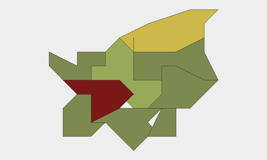
Città di San Marino (risk score 85) and Serravalle (68) drive the country's composite risk primarily due to population density, tourism transits, and event hosting rather than active conflict or crime. These capitals of the two most populous castelli naturally concentrate administrative, commercial, and visitor traffic. Borgo Maggiore (52) follows at distance, with remaining six castelli registering low single-digit to mid-range scores reflecting smaller populations and reduced infrastructure/human-density footprint. The risk ranking reflects *structural exposure* (people and assets in proximity) rather than elevated threat activity in any district.
How GeoBit Would Assist
A corporate security team with personnel or assets in San Marino would deploy AOI (Area-of-Interest) Monitoring & Early Warning on Città di San Marino and Serravalle to detect any abrupt shift in event frequency or nature. Multi-language OSINT sweep (X/Twitter, Telegram, local news feeds) coupled with sentiment and temporal analysis would provide continuous low-cost baseline monitoring for protest activity, labor disputes, or infrastructure failures affecting business continuity. Environmental & Health and Routing & Network Analysis capabilities would support contingency planning for weather-driven disruptions and alternative supply or mobility pathways during storm or drought periods.
7-Day Outlook
Weather patterns are forecast to stabilize by mid-week; the orange storm alert is expected to downgrade, though hydrogeological and drought alerts will likely persist through autumn. No indicators suggest political, civil, or security escalation. Corporate operations should maintain routine storm-preparedness protocols and monitor local infrastructure notices for localized access disruptions in smaller castelli.
Highest-Risk Areas — Ranked
| # | State / Region | Risk |
|---|---|---|
| 1 | Città di San Marino | 85 |
| 2 | Serravalle | 68 |
| 3 | Borgo Maggiore | 52 |
| 4 | Fiorentino | 32 |
| 5 | Domagnano | 28 |
| 6 | Faetano | 22 |
| 7 | Chiesanuova | 18 |
| 8 | Montegiardino | 16 |
| 9 | Acquaviva | 15 |
Sources
Previous Weekly Briefs
A new San Marino brief is written every Monday, covering the week — each with its own risk map and downloadable CSV. Use the calendar to go further back.
- September 8, 2026
- September 2, 2026
- August 30, 2026
- August 27, 2026
- August 24, 2026
- August 21, 2026
- August 18, 2026
📅 Browse past briefs by calendar →
Highlighted days have a brief. Tap a day for that day's map & analysis, or “csv” for that day's dataset ($5).
Atlas — our AI intelligence desk — emails them this snapshot personally. Nothing else, no list.