Situation Summary
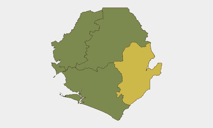
Sierra Leone remains a low-threat environment overall (global rank #131, composite score 6), with no verified security incidents reported in the last 24–48 hours. The primary near-term public-health concern is an active cholera signal requiring epidemiological monitoring. Subnational risk is heavily concentrated in the Eastern Province, which accounts for the majority of the country's measurable threat profile.
Key Developments
- No verified security incidents — live web research covering the last 24–48 hours identified no confirmed armed conflict, civil unrest, major crime, political instability, or travel disruption events in Sierra Leone.
- Cholera signal (timeframe: recent) — epidemiological monitoring indicates active cholera circulation; no specific date, location, or case count was available in the reporting window, but health teams should confirm case clustering and outbreak status via national health authorities.
- No regional spillover detected — while neighboring states (Guinea, Liberia) carry elevated instability risk, no confirmed cross-border security incidents affecting Sierra Leone were detected in the last 48 hours.
- Eastern Province remains focal point — concentrated risk (score 68) in the Eastern Province reflects ongoing monitoring; specific incident drivers were not detailed in current reporting but warrant AOI-level surveillance to detect escalation.
Highest-Risk Areas
The Eastern Province dominates Sierra Leone's subnational risk landscape (score 68), representing nearly two-thirds of national measurable threat and the clear priority for duty-of-care monitoring. The Western Area, encompassing the capital Freetown and surrounding urban zones, carries secondary but material risk (score 35), reflecting typical urban crime, health, and civil-order dynamics. Northern, North West, and Southern provinces register zero composite scores and are treated as lower-priority monitoring zones under current threat metrics. Organizations with operations or personnel in the Eastern Province should apply heightened awareness protocols; Western Area presence warrants standard urban security practices.
How GeoBit Would Assist
Teams with staff or assets in Sierra Leone should deploy AOI Monitoring & Early Warning against the Eastern Province and Freetown to detect emergence of conflict, crime, or health events with automated alerting. Intel Sweep and global event feeds provide continuous OSINT fusion to catch incidents that open-source media may delay or miss. Environmental & Health intelligence capabilities support real-time tracking of the cholera signal and prediction of spillover risk, enabling coordination with medical and humanitarian partners. Routing & Network Analysis can generate alternative transport corridors and safe-passage planning if localized incidents require personnel movement or evacuation.
7-Day Outlook
No imminent tactical security escalation is forecast over the next 7 days; the threat environment is expected to remain stable absent major regional spillover from Guinea or Liberia. Cholera surveillance should remain active given the health signal; seasonal patterns and rainy-season conditions may accelerate transmission if confirmed in endemic zones. Routine monitoring of the Eastern Province is advised to detect any change in baseline risk indicators.
Next Update: 2026-06-25 | Data Confidence: High (open-source) | Caveats: No classified reporting; local security partner input recommended for ground-truth validation.
Highest-Risk Areas — Ranked
| # | State / Region | Risk |
|---|---|---|
| 1 | Eastern Province | 68 |
| 2 | Western Area | 35 |
| 3 | North West Province, Sierra Leone | 0 |
| 4 | Northern Province, Sierra Leone | 0 |
| 5 | Southern Province, Sierra Leone | 0 |
Sources
Previous Daily Briefs
A new Sierra Leone brief is written every day — each with its own risk map and downloadable CSV. Here's the last week; use the calendar to go further back.
📅 Browse every day by calendar →
Highlighted days have a brief. Tap a day for that day's map & analysis, or “csv” for that day's dataset ($5).