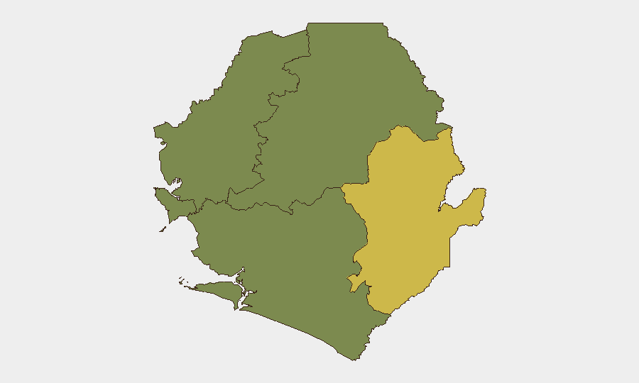
Situation Summary
Sierra Leone remains a low-threat environment globally (rank #90, composite score 12) with no corroborated security incidents, active conflict, or civil unrest reported in the last 24–48 hours. The country's primary documented risk signal is a cholera outbreak, a public-health rather than security matter, requiring hygiene and medical infrastructure focus. Eastern Province exhibits elevated composite risk (68), driven by historical vulnerability factors and cross-border exposure, but no acute incident activity is currently tracked. The security operating environment remains stable with manageable duty-of-care requirements for resident and transiting personnel and assets.
Key Developments
No corroborated security, conflict, civil-unrest, crime, political-instability, or infrastructure incidents were identified in Sierra Leone during the last 24–48 hours. Current event intelligence is limited to the ongoing cholera signal, which is epidemiological rather than security-classified. Live web research did not surface journalist reports, NGO alerts, police announcements, or verified local social-media incident posts from the reporting window. Absence of incident activity does not imply zero risk; rather, it reflects a period of baseline stability. Teams requiring sub-24-hour incident alerting should enable GeoBit AOI Monitoring & Early Warning with area-specific triggers for rapid notification if conditions change.
Highest-Risk Areas
Eastern Province (risk 68) dominates the sub-national profile and warrants the most active monitoring. Risk drivers include historical cross-border movement, porous frontier zones, and lingering vulnerability to smuggling and informal-economy dynamics; however, no acute instability or organized violence is currently documented. Western Area (risk 35), encompassing Freetown and the capital region, carries secondary risk largely tied to urban crime, congestion, and service-delivery gaps rather than political or conflict-related threats. Northern, North West, and Southern Provinces all register zero composite risk and are assessed as stable. Personnel and asset positioning should weight Eastern Province for enhanced awareness and alternative routing capability; Western Area requires standard urban-security precautions rather than elevated alert.
How GeoBit Would Assist
Intel Sweep and multi-language OSINT searches focused on Eastern Province and border zones (Guinea, Liberia) would establish a continuous baseline of regional stability and flag any emerging cross-border activity or informal-economy disruption. AOI Monitoring & Early Warning pinned to Eastern Province, Freetown port, and key transport corridors would provide 24/7 alerting if security, health, or infrastructure incidents spike. Routing & Network Analysis tools enable security teams to pre-plan alternative journey paths around Eastern Province should conditions deteriorate, and Sentiment & Temporal Analysis of local media and social channels would detect shifts in public mood or institutional stress early enough for preventive duty-of-care adjustments.
7-Day Outlook
No material change in Sierra Leone's baseline security posture is anticipated over the next seven days. Cholera containment and public-health messaging remain the dominant national priority. The country's macro-stability—low political tension, no organized armed groups, functioning state institutions—is expected to persist, sustaining the current low-threat environment for corporate and resident operations. Continued monitoring of Eastern Province and port activity remains prudent as a matter of routine risk hygiene.
Highest-Risk Areas — Ranked
| # | State / Region | Risk |
|---|---|---|
| 1 | Eastern Province | 68 |
| 2 | Western Area | 35 |
| 3 | North West Province, Sierra Leone | 0 |
| 4 | Northern Province, Sierra Leone | 0 |
| 5 | Southern Province, Sierra Leone | 0 |
Sources
Previous Daily Briefs
A new Sierra Leone brief is written every day — each with its own risk map and downloadable CSV. Here's the last week; use the calendar to go further back.
📅 Browse every day by calendar →
Highlighted days have a brief. Tap a day for that day's map & analysis, or “csv” for that day's dataset ($5).