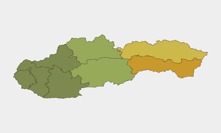
Situation Summary
Slovakia remains a low-threat environment (rank #169 globally) with no tracked security incidents or civil unrest reported. Recent event signals cluster around transport and infrastructure incidents—a garbage-truck overturn and structural fires in residential and forest areas—rather than security or crime concerns. The threat landscape is stable, though regional variance is marked: eastern regions (Košice, Prešov) show elevated composite risk scores, likely reflecting economic and demographic factors rather than acute security events. Overall trajectory remains benign for corporate operations.
Key Developments
- 2026-08-08 · Bravacovo (Region of Banská Bystrica) – Destructive night fire consumed ten residential/commercial buildings; firefighting response deployed. No casualties or security implications reported; impact is infrastructure and insurance-driven.
- 2026-08-08 · Trstina (eastern Slovakia) – Large forest fire required multi-unit firefighter response. No transport disruptions or populated-area threats confirmed; seasonal risk factor in context of reported high temperatures across southern Slovakia.
- 2026-08-07 · Ružinov, Bratislava – Garbage truck overturned at Prístavná–Slovnaftská intersection; one sanitation worker extracted via firefighter rescue. Localized traffic impact; no security incident.
- Unconfirmed signals – Secondary sources reference a fire at an undisclosed military training ground and a fire at the Slovnaft industrial facility (location/date not independently verified in available sources). These require corroboration before inclusion in operational planning.
Highest-Risk Areas
The eastern regions of Košice (risk 72) and Prešov (risk 68) drive the national risk profile and merit targeted monitoring by security teams. Banská Bystrica (risk 55) rounds out the elevated-risk cluster. These scores likely reflect structural factors—economic indicators, population density, or historical crime/accident data—rather than current acute threats. By contrast, the western and central regions (Bratislava, Trenčín, Trnava) carry substantially lower composite scores (18–28), signaling better baseline conditions for corporate operations. Teams with personnel or assets in the eastern corridor should maintain standard vigilance protocols and local liaison channels.
How GeoBit Would Assist
Teams should deploy AOI Monitoring & Early Warning on the eastern regions to track emerging events (crime, civil unrest, transport disruption, industrial incidents) with automated alerting. Intel Sweep combined with multi-language OSINT and X/Telegram monitoring provides real-time signal capture across Slovak media, official sources, and social networks to fill gaps in English-language reporting and catch early warning of labor, environmental, or political friction. Routing & Network Analysis can generate alternative travel and logistics corridors in the event of infrastructure degradation or regional instability, reducing exposure to chokepoints in Košice or Prešov regions.
7-Day Outlook
No escalation in threat level is anticipated over the next seven days. Seasonal heat and associated fire risk in forested and rural areas will persist; teams should monitor weather advisories and emergency-service capacity in eastern regions. Barring unforeseen economic, political, or labor developments, Slovakia will remain a low-friction operating environment for corporate duty-of-care requirements.
Highest-Risk Areas — Ranked
| # | State / Region | Risk |
|---|---|---|
| 1 | Region of Košice | 72 |
| 2 | Region of Prešov | 68 |
| 3 | Region of Banská Bystrica | 55 |
| 4 | Region of Žilina | 42 |
| 5 | Region of Nitra | 35 |
| 6 | Region of Bratislava | 28 |
| 7 | Region of Trenčín | 22 |
| 8 | Region of Trnava | 18 |
Sources
Previous Daily Briefs
A new Slovakia brief is written every day — each with its own risk map and downloadable CSV. Here's the last week; use the calendar to go further back.
📅 Browse every day by calendar →
Highlighted days have a brief. Tap a day for that day's map & analysis, or “csv” for that day's dataset ($5).
Atlas — our AI intelligence desk — emails them this snapshot personally. Nothing else, no list.