Situation Summary
Solomon Islands remains a low-threat environment nationally, ranked #171 globally with a composite threat score of 4 and no tracked security events in the past 24–48 hours. Current open-source and real-time monitoring confirm stable conditions across transport, port, airport, and civil infrastructure. The security posture is stable with no indicators of imminent deterioration.
Key Developments
- No verified security incidents in the last 24–48 hours. Near-real-time monitoring across Solomon Islands (including Honiara and provincial centers) has identified no civil unrest, political violence, major crime spikes, infrastructure disruption, or transport impediments as of 11 July 2026.
- Regional strategic development: China ballistic missile test. A ballistic missile test conducted by China on or around 11 July transited the Pacific region and passed near Tuvalu's exclusive economic zone; this is a regional geopolitical and strategic event rather than a direct Solomon Islands security incident, but may merit diplomatic or policy review by organizations with Pacific-wide exposure.
- Historical investigation ongoing. Solomon Islands police continue investigation into civil unrest incidents from the prior year; this is a legacy matter and does not reflect new instability.
- Transport and logistics normal. Ports, airports, and maritime corridors continue to operate within normal parameters with no disruptions reported.
Highest-Risk Areas
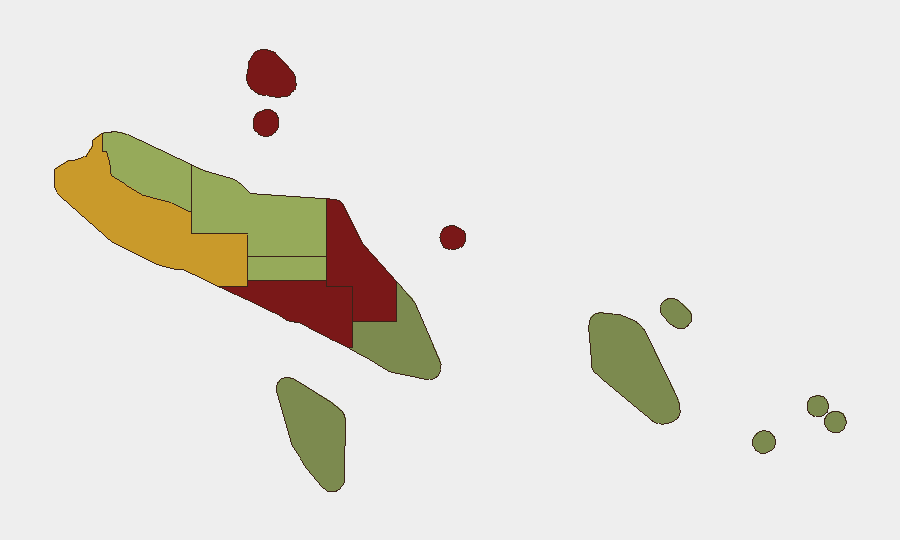
Honiara (risk 92) and Guadalcanal (risk 88) drive the national risk profile, followed by Malaita (85) and Western Province (72). These four regions account for the majority of composite risk. Honiara's elevated score reflects urban crime, gang activity, and petty theft—common in Pacific capital environments—rather than acute political or civil instability. Guadalcanal and Malaita carry historical communal tensions and sporadic inter-group friction. Western Province risk reflects logistics, remoteness, and maritime crime vectors. Choiseul, Isabel, and Central Province carry moderate scores; the southern and eastern regions (Makira-Ulawa, Rennell and Bellona, Temotu) remain genuinely low-risk.
How GeoBit Would Assist
AOI Monitoring & Early Warning with persistent watch on Honiara, Guadalcanal, and Malaita would provide alerting on the emergence of civil unrest, crime spikes, or political friction. OSINT fusion across local news, social media, and Telegram feeds would capture informal community signals ahead of formal reporting. Conflict mapping and regime-stability search would track any drift toward organized communal violence or erosion of state authority. Combined, these capabilities enable corporate security and duty-of-care teams to maintain real-time situational awareness and trigger escalation protocols if conditions shift.
7-Day Outlook
No acute threats are forecast for the next seven days. The seasonal and political environment remains stable, with no scheduled elections, large gatherings, or known flashpoints. Routine monitoring for opportunistic street crime in Honiara and low-level maritime activity in Western Province should continue as standard practice.
Highest-Risk Areas — Ranked
| # | State / Region | Risk |
|---|---|---|
| 1 | Honiara | 92 |
| 2 | Guadalcanal | 88 |
| 3 | Malaita | 85 |
| 4 | Western | 72 |
| 5 | Choiseul | 58 |
| 6 | Isabel | 52 |
| 7 | Central Province | 48 |
| 8 | Makira-Ulawa | 38 |
| 9 | Rennell and Bellona | 22 |
| 10 | Temotu | 18 |
Sources
Previous Daily Briefs
A new Solomon Islands brief is written every day — each with its own risk map and downloadable CSV. Here's the last week; use the calendar to go further back.
📅 Browse every day by calendar →
Highlighted days have a brief. Tap a day for that day's map & analysis, or “csv” for that day's dataset ($5).
Atlas — our AI intelligence desk — emails them this snapshot personally. Nothing else, no list.