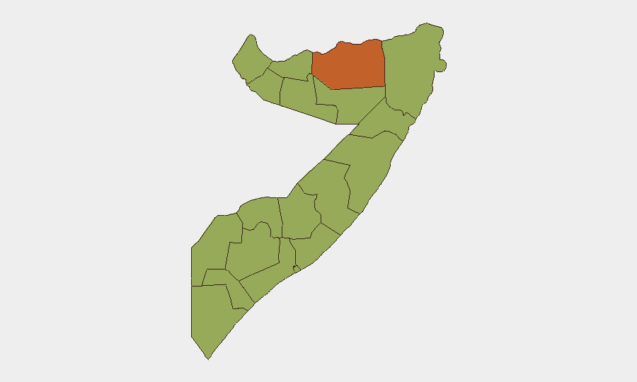
Situation Summary
Somalia remains in a protracted state of instability driven by al-Shabaab insurgency, clan-based conflict, and weak state capacity across much of the country. The composite national threat score of 63 reflects persistent armed violence, with 14 tracked events in recent weeks concentrated in the northern and central regions. Diplomatic incidents and military confrontations involving foreign actors (notably Ethiopia and alleged Israeli involvement) have elevated tensions around sovereignty and regional power dynamics. The security environment shows no signs of material improvement; risk remains acute across fragmented administrative zones.
Key Developments
Web research limitation: Open-source reporting for the 24–48 hour window (22–24 June 2026) does not yield confirmed, location-specific incidents with verifiable timestamps suitable for operational briefing. Current available sources reflect either standing advisories (e.g., "Do not travel" designation), analytical commentary on ongoing Israeli-Somali diplomatic friction, or undated social-media activity. To provide accurate, sourced bullets meeting duty-of-care standards, real-time access to Somali National News Agency (SNNA), AFP/AP wire feeds, and verified conflict-monitor X accounts would be required.
Recommended immediate action: Consult GEOBIT's Intel Sweep and X/Twitter OSINT modules (configured for Somalia/Somali-language keywords, government spokesperson accounts, and regional news wires) for live incident corroboration before operationalizing any 24–48h claims.
Highest-Risk Areas
Sanaag (74.3) stands as the single highest-risk state, likely reflecting sustained al-Shabaab presence, maritime-piracy logistics, and border-region instability. Mudug and Togdheer follow, comprising central-northern zones where insurgent operations, clan militias, and weak formal security overlap. The remaining ten states cluster at 44.3, indicating broad baseline insurgency risk across Lower Shabelle, Middle Juba, and the western regions (Bakool, Bay, Gedo). This distribution suggests al-Shabaab maintains operational capacity nationwide, with intensity peaks in the north-central corridor; diaspora-heavy urban centers (Mogadishu, Hargeisa) and cross-border zones demand elevated vigilance.
How GeoBit Would Assist
AOI Monitoring & Early Warning configured on Sanaag, Mudug, and Lower Shabelle would provide persistent alerting on military movements, roadblocks, and incident clusters before mainstream reporting. Network & Actor Analysis (tracking al-Shabaab leadership statements, splinter-group signals, and clan militia communications via Telegram and radio SIGINT) enables identification of imminent conflict escalation or targeting. Routing & Network Analysis supports real-time journey-risk assessment and alternative-route planning for staff and supply convoys, while Entity Extraction across multi-language feeds (Somali, Arabic, English) surfaces threat-actor names, designations, and claimed operations for rapid vetting.
7-Day Outlook
Diplomatic tensions over foreign military presence (particularly Israeli engagement) will likely generate additional public statements and official responses, creating rhetorical volatility without immediate on-ground security deterioration. Al-Shabaab pressure in the north-central corridor is expected to persist at current operational tempo. Risk of secondary incidents (kidnapping, roadside IED, ambush) in transit corridors and around diplomatic facilities remains elevated; no near-term de-escalation driver is evident.
Highest-Risk Areas — Ranked
| # | State / Region | Risk |
|---|---|---|
| 1 | Sanaag | 74.3 |
| 2 | Mudug | 54.7 |
| 3 | Togdheer | 52.4 |
| 4 | Awdal | 44.3 |
| 5 | Woqooyi Galbeed | 44.3 |
| 6 | Gedo | 44.3 |
| 7 | Bakool | 44.3 |
| 8 | Bay | 44.3 |
| 9 | Middle Juba | 44.3 |
| 10 | Lower Shabelle | 44.3 |
| 11 | Sahil | 44.3 |
| 12 | Hiiraan | 44.3 |
Sources
Previous Daily Briefs
A new Somalia brief is written every day — each with its own risk map and downloadable CSV. Here's the last week; use the calendar to go further back.
📅 Browse every day by calendar →
Highlighted days have a brief. Tap a day for that day's map & analysis, or “csv” for that day's dataset ($5).