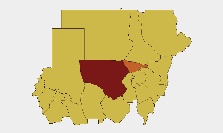
Situation Summary
Sudan remains in active civil conflict between the Sudanese Armed Forces (SAF) and the Rapid Support Forces (RSF), with North Kordofan State emerging as the epicenter of highest-risk activity. Compound instability across the Nile River corridor and Darfur regions continues to drive displacement, detention operations, and sporadic military engagements. Foreign involvement—signaled by recent public statements and reported incidents involving UK and US actors—adds complexity to operational security for international personnel and assets. The trajectory remains volatile with no clear de-escalation pathway visible in near-term indicators.
Key Developments
Data Limitation Notice: Open-source verification of specific incidents in the 24–48 hours preceding 14 June 2026 remains fragmented. GeoBit's event signals show multiple arrest/detention and military force signals dated 12–14 June involving Sudanese, UK, and US actors; however, precise locations, casualty counts, and independent multi-source confirmation are unavailable in current open reporting. Social media reports of clashes, airstrikes, and checkpoint incidents circulate without timestamps or corroboration.
- Detention Operations (12–14 June): Multiple arrest/detention signals recorded, including incidents involving UK nationals and Sudanese authorities; circumstances and locations require field verification.
- Military Engagements (12–14 June): Conventional military force indicators involving SAF/RSF and foreign actors reported; specific battlespace locations unconfirmed in independent sources.
- Diplomatic Escalation (13 June): Sudan's UN mission issued public statements against US involvement; Sudanese-Eritrean actor tensions also signaled.
- Humanitarian Alert (12 June, South Darfur): Sudan's UN ambassador documented allegations of mass detention, torture, and organ trafficking at Daghris Prison in Nyala (South Darfur); describes ongoing conditions rather than a discrete new incident.
Highest-Risk Areas
North Kordofan State (composite risk 100) dominates the threat landscape and should be treated as a no-go zone for non-essential personnel; active SAF-RSF combat operations and resource competition characterize the region. Al Khartum (75.6) remains volatile due to checkpoint proliferation, detention risks, and mixed civilian-military presence; Blue Nile, River Nile, and Darfur sub-states (all ranked 70) form a high-risk corridor along logistics routes and resource zones where military control is contested or fragmentary. Red Sea, Kassala, Sennar, and Al Qadarif states mirror this pattern, indicating that geographic control is diffuse and that safe passage cannot be assumed without real-time field intelligence.
How GeoBit Would Assist
Security teams should deploy AOI (Area-of-Interest) Monitoring & Early Warning on North Kordofan, Al Khartum, and key transit nodes to flag checkpoint activity, military movements, and detention sweeps with minimal latency. Intel Sweep and Conflict/Military battle mapping capabilities enable fusion of radio SIGINT, social-media OSINT, and satellite imagery to build high-confidence incident pictures and validate claims before operational decisions. Routing & Network Analysis and GIS & Spatial Analysis tools allow real-time route optimization around high-risk zones, reducing exposure to military clashes and checkpoint interdiction.
7-Day Outlook
Military activity intensity is likely to remain elevated across North Kordofan and the Nile corridor; no major peace talks or ceasefires are signaled. International actor presence (UK, US) and public statements suggest potential for further incidents involving foreign nationals, increasing duty-of-care exposure. Organizations with personnel or assets in Sudan should assume checkpoint delays, detention risk, and limited state authority; real-time field updates and rapid decision protocols are essential.
Highest-Risk Areas — Ranked
| # | State / Region | Risk |
|---|---|---|
| 1 | North Kordofan State | 100 |
| 2 | Al Khartum | 75.6 |
| 3 | Blue Nile | 70 |
| 4 | River Nile State | 70 |
| 5 | Aj Jazira | 70 |
| 6 | Red Sea State | 70 |
| 7 | Al Qadarif State | 70 |
| 8 | Kassala State | 70 |
| 9 | Sennar State | 70 |
| 10 | Central Darfur State | 70 |
| 11 | South Darfur State | 70 |
| 12 | West Kurdufan State | 70 |
Sources
Previous Daily Briefs
A new Sudan brief is written every day — each with its own risk map and downloadable CSV. Here's the last week; use the calendar to go further back.
📅 Browse every day by calendar →
Highlighted days have a brief. Tap a day for that day's map & analysis, or “csv” for that day's dataset ($5).